

Fix Sunland Boulevard Safety Crisis in Shadow Hills
The Issue
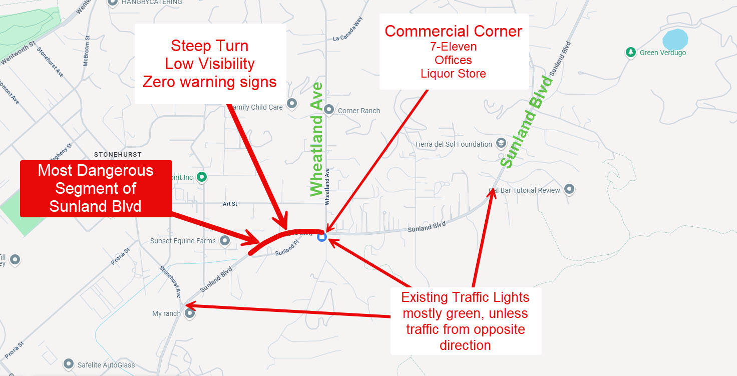
We, the undersigned residents and business owners of Shadow Hills, write to the City of Los Angeles Department of Transportation and City Authorities to express our deep concern regarding the ongoing traffic dangers on Sunland Boulevard between Stonehurst Avenue and the I-210 Freeway, with particular focus on the eastbound curve leading to the intersection at Sunland Boulevard and Wheatland Avenue.
Although this section is posted at 45 mph, the reality on the ground is far different. Drivers routinely travel at 55 to 75 mph, turning what should be a calm, mixed-use community corridor into a high-speed thoroughfare. In addition to passenger vehicles, large commercial trucks and heavy haulers thunder through the business section at 45–55 mph, generating deafening air noise and ground vibration that shakes nearby buildings and rattles windows as if the entire street is experiencing a miniature earthquake.
The constant roar and shock waves from these trucks make ordinary daily life working in nearby offices, sitting at local restaurants and cafes, or simply standing on the sidewalk, feel unsafe and unsettling. The U.S. Postal Service delivers mail daily along this same stretch, and trash trucks regularly stop to collect from homes and businesses, forcing them to share the roadway with speeding traffic.
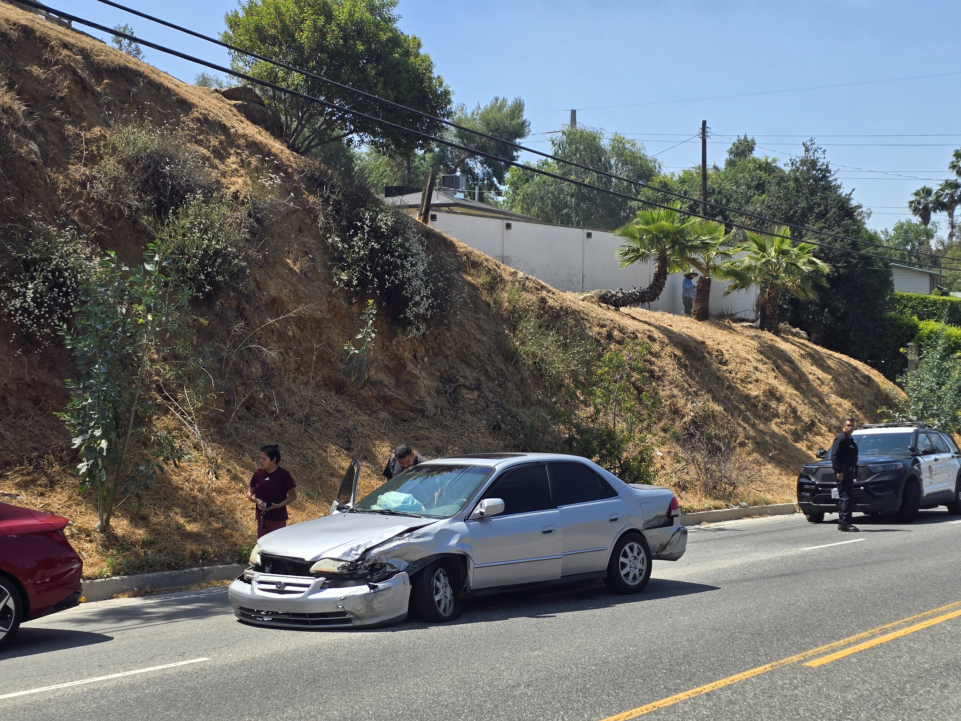
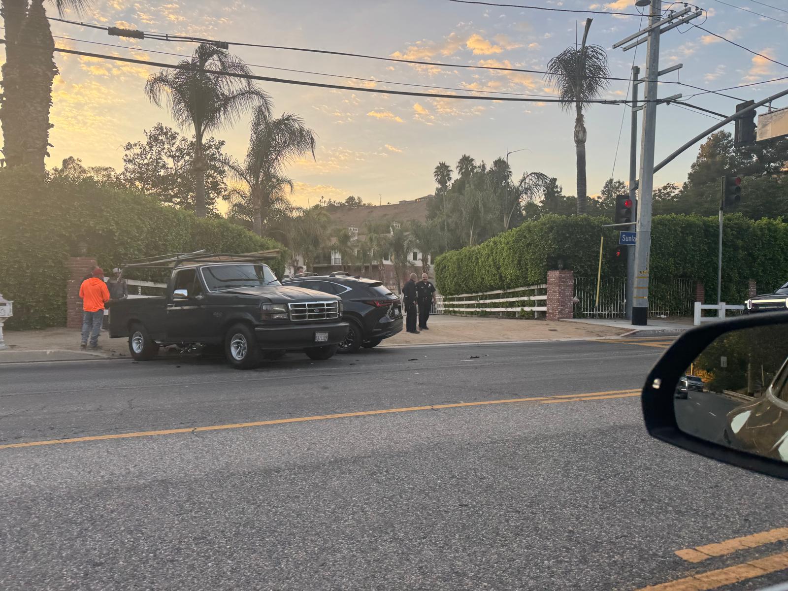
Ironically, the boulevard is virtually empty 90% of the time, leaving enormous, unused pavement that only encourages higher speeds. Despite repeated community complaints, there have been frequent collisions, near-misses, and serious injuries, including three major crashes within a single week in May 2025. The combination of high-speed traffic, low usage, and unchecked truck activity has turned this section of Sunland Boulevard into a dangerous and deeply disruptive environment for the community that lives and works along it.
The boulevard is missing critical traffic safety signs and warnings, including curve advisories, reduced speed notifications, and “Traffic Signal Ahead” alerts. The roadway itself presents restricted visibility, sharp horizontal and vertical curvature, and numerous hidden driveways, all compounded by dense shrubbery extending to the curb line, which often forces pedestrians, cyclists, and even equestrian riders into the roadway.
Although partial guardrails were installed to protect property at some segments, there remains no raised median, no consistent signage, and no speed reduction to protect human life. The entire length of Sunland Boulevard includes active equestrian trails, making these design and visibility issues even more dangerous. Furthermore, there have been numerous unreported or undocumented accidents, which seem to have prevented the City from fully recognizing the extent of the hazard and taking appropriate corrective action.
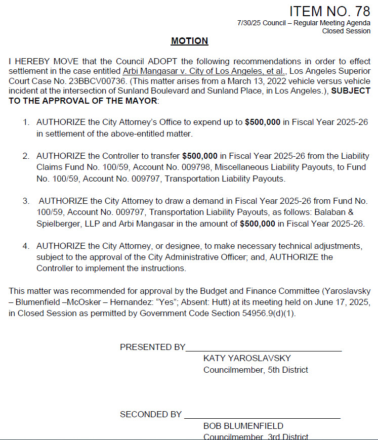
RECENT MAJOR ACCIDENT AND CITY LIABILITY (Motion Item No.78)
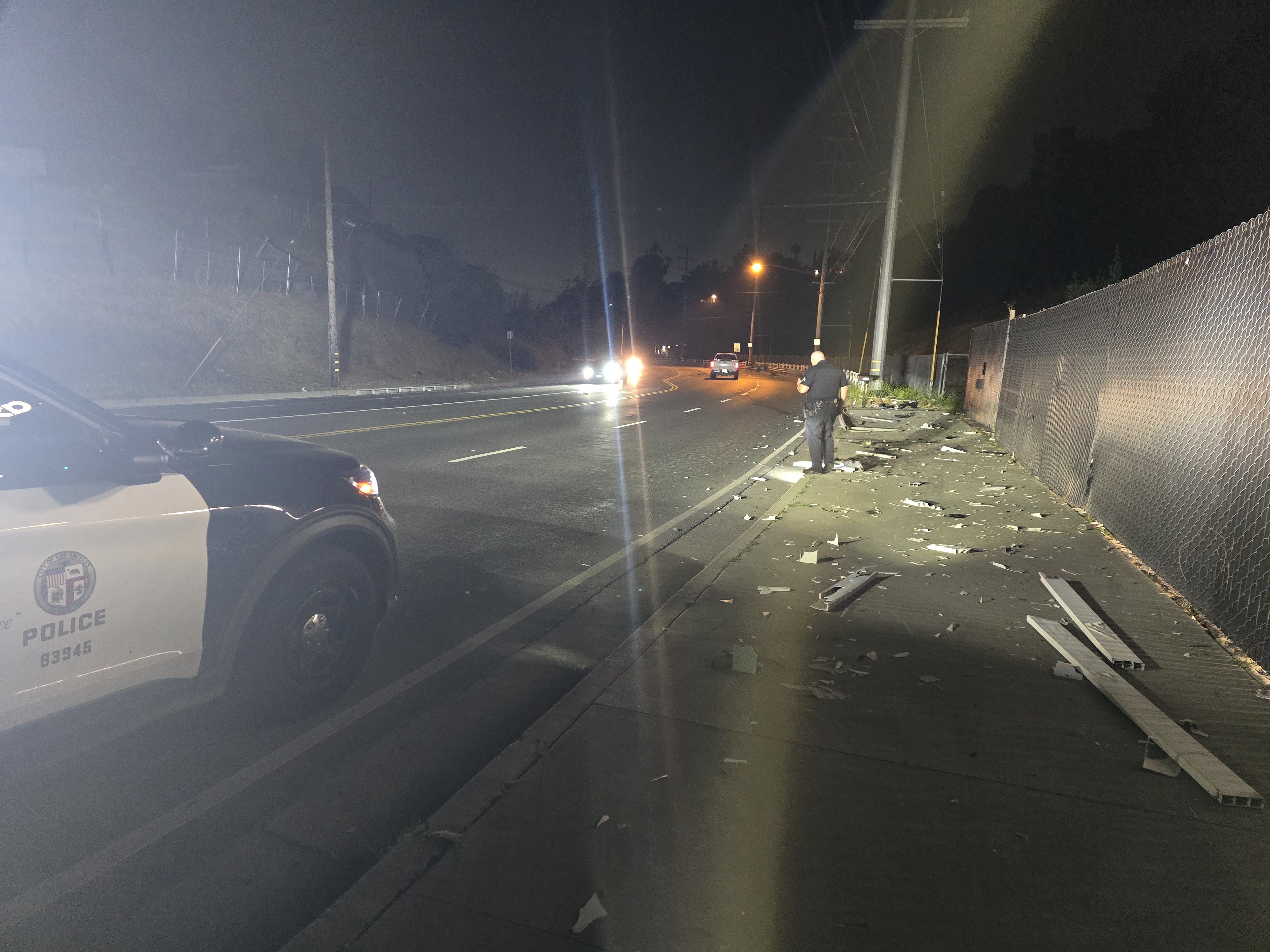
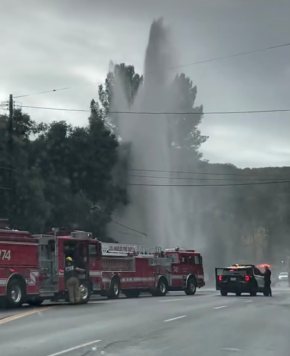
On March 13, 2022, a severe vehicle collision occurred at the Sunland Boulevard and Sunland Place curve, resulting in serious injuries and significant property damage.
This incident led to the case Arbi Mangasar v. City of Los Angeles (Los Angeles Superior Court No. 23BBCV00736). On July 30, 2025, the Los Angeles City Council approved a $500,000 payment in this matter (Council File 25-0552), paid from the City’s Transportation Liability Fund.
This public record confirms that the City has already incurred substantial liability due to dangerous roadway conditions on Sunland Boulevard. The same segment remains largely unchanged today lacking curve warnings, advisory speed signage, median protection, or advance signal warnings leaving residents and drivers exposed to the same risks that triggered the 2022 crash.
TRAFFIC CONDITIONS AND SAFETY HAZARDS
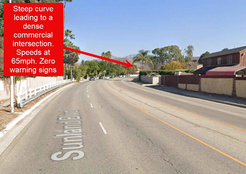
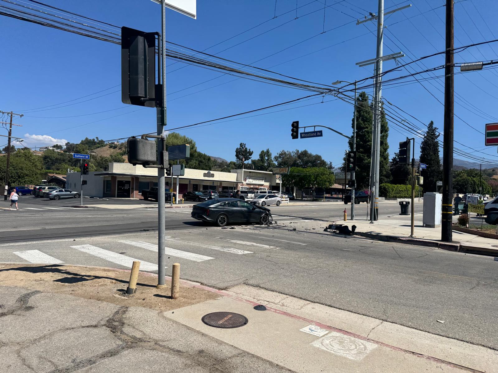
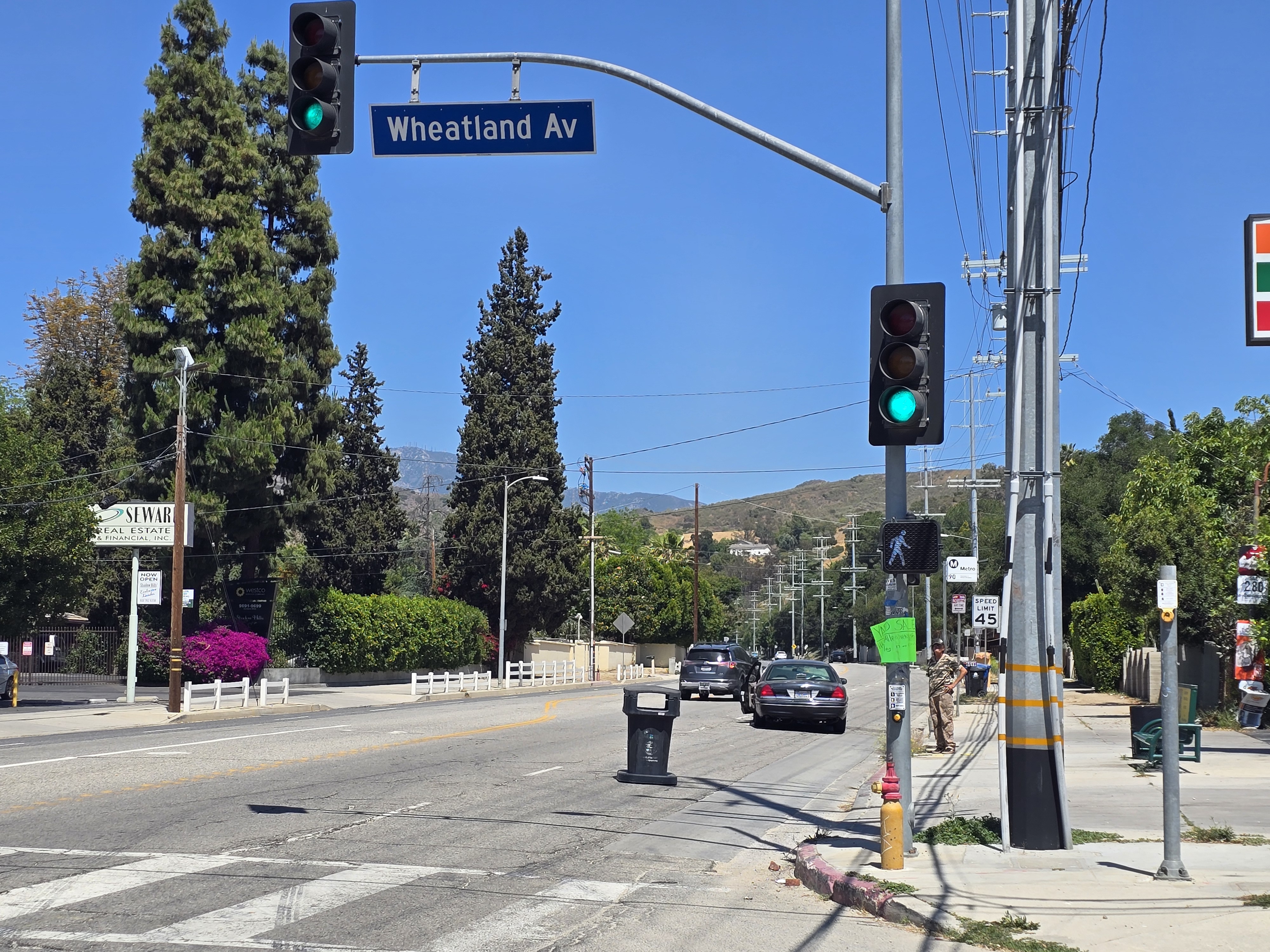
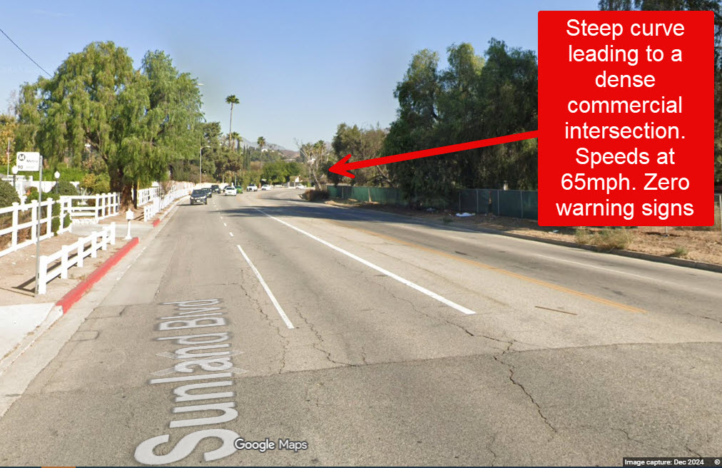
The steep curve west of Wheatland Avenue along Sunland Boulevard leading to the commercial intersection is one of the most dangerous segments on this road. It lacks any curve-warning signs, advisory-speed plaques, or “Traffic Signal Ahead” signage. As a result, eastbound drivers are often surprised by the signal and accelerate to beat the light, creating frequent high-speed conflicts. Numerous driveways and cross-streets along this stretch require vehicles to slow or turn abruptly into fast-moving traffic.
Despite these hazards, Sunland Boulevard is significantly underutilized for its width and lane configuration. This excess capacity invites speeding by both passenger vehicles and heavy commercial trucks, turning the corridor into an informal high-speed zone.
There is ample room to reduce speeds, reconfigure lanes, and implement safety measures without causing congestion or impeding traffic flow. A proper traffic and engineering study will confirm this and provide the data needed to support these changes.
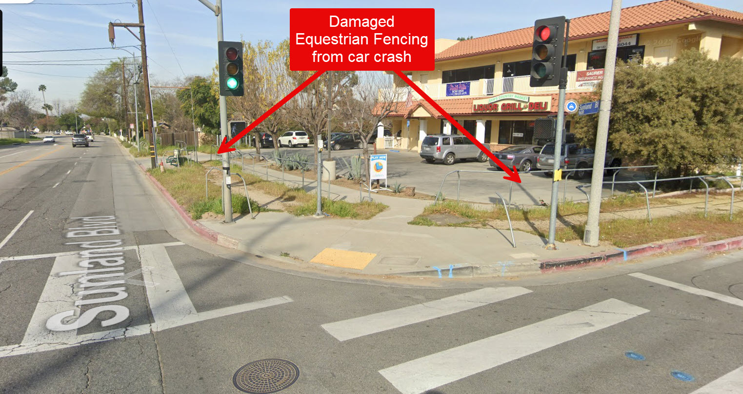
Over the years, these design deficiencies have resulted in broken guardrails, damaged equestrian fencing, multiple injury-causing accidents, and even the destruction of the U.S. Postal Service mailbox at the 7-Eleven plaza. Local businesses have witnessed dozens of collisions and hundreds of near-misses.
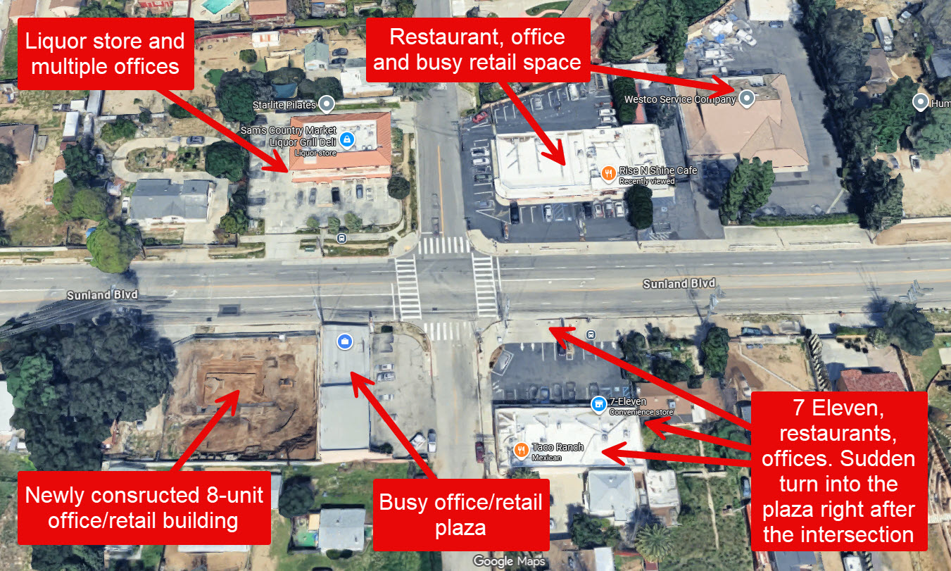
The access driveway to the commercial plaza housing 7-Eleven is located immediately after the intersection, where vehicles traveling at 60 mph or more are often caught off guard by drivers slowing or stopping, sometimes without turn signals, to enter the plaza. Just beyond the steep curve lies another new commercial plaza, requiring a sharp 90-degree turn into its driveway. There is critically low visibility for speeding drivers to recognize slowed or stopped vehicles, postal and trash service vehicles, or buses ahead. Together, these conditions create a life-threatening environment for motorists, pedestrians, and equestrians alike.
CRITICALLY DANGEROUS SEGMENT. VISIBILITY BELOW MINIMUM AASHTO STANDARDS
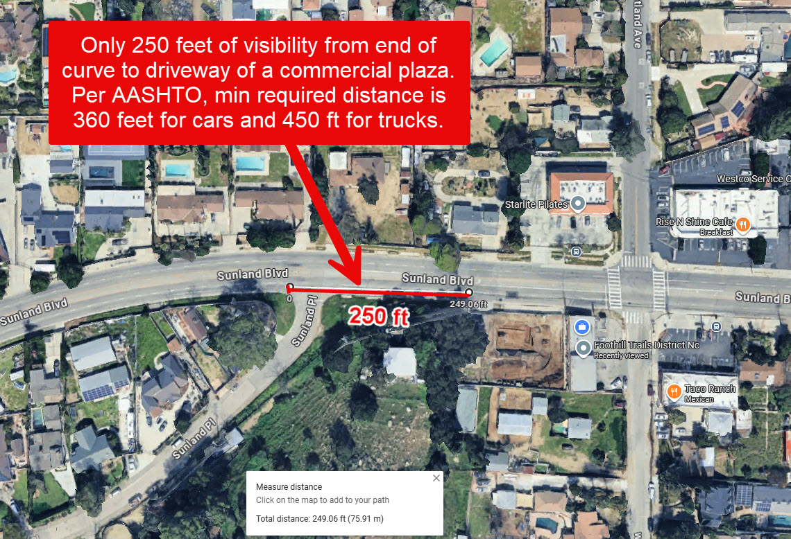
On the west side of Wheatland Avenue along Sunland Boulevard, eastbound drivers encounter a steep curve immediately followed by a driveway located approximately 250 feet beyond the curve. This driveway serves a newly constructed commercial plaza with active daily traffic and an existing residential property, requiring a nearly 90-degree turn from the main roadway.
The available sight distance of roughly 250 feet falls far short of the minimum 360 feet required at the posted 45 mph speed under AASHTO and Caltrans design standards for stopping sight distance.
This means that a driver traveling at the current speed limit cannot safely perceive and react to a vehicle turning into or exiting this driveway in time to stop. The situation is even more dangerous for large trucks or delivery vehicles, which need more than 400 feet to stop. Reducing the speed limit to 35 mph would bring this segment into compliance with safety standards, as that speed aligns with the available 250-foot visibility. Immediate speed reduction, “Hidden Driveway” warning signage, and advance curve and signal warnings are critical to prevent serious collisions at this location.
HISTORICAL AND PLANNING CONTEXT
Sunland Boulevard was originally constructed in 1907, along with neighboring Wentworth Street, to serve the early Sunland–Tujunga agricultural settlements. At the time, these roads traversed open farmland and olive orchards, designed primarily for automobile access between the foothill communities and the San Fernando Valley. There was little to no roadside development or pedestrian activity for many decades.
The Sunland and Wheatland intersection remained mostly undeveloped until the 1950s, when the first buildings appeared at the northeast and southwest corners. Over subsequent decades, the intersection gradually evolved into a commercial and mixed-use hub serving the growing community:
- The current 7-Eleven building (southeast corner) was built in the 1960s, with the 7-Eleven store opening in 2010.
The liquor store and second-floor offices at the northwest corner were built in 2012, including a Pilates studio and other professional tenants generating daily foot and vehicle traffic. - A 6,000-square-foot commercial and retail building was constructed at the southwest corner in 2025, introducing new businesses and a dedicated equestrian trail along the frontage.
- A large pharmacy is currently under construction at the northeast corner, and it is expected to further increase vehicle turning movements, parking demand, and pedestrian crossings.
These cumulative developments have turned what was once a quiet rural corridor into an active, high-traffic business district with constant interaction between motorists, pedestrians, and equestrians.
Despite this transformation, the posted 45-mph speed limit remains based on conditions from traffic studies dating back to 2009. The City of Los Angeles Department of Transportation (LADOT) report dated August 13, 2009, recommended retaining the 45-mph limit based on an accident rate of 0.93 per million vehicle miles and a critical speed of 41.5 mph, referencing only “small businesses near Wheatland Avenue.”
A subsequent LADOT Board report of July 24, 2012 noted that the speed zone survey between Foothill and Vineland was already expired, yet no new study was completed.
Since those reports, both population and traffic volumes have increased substantially:
- The population of Shadow Hills grew from 13,098 in 2008 (per Los Angeles Times, Mapping L.A.) to approximately 14,800 in 2025 (per Niche.com), a rise of over 13 percent.
- The City’s own 24-hour traffic volume count for Sunland Boulevard shows an increase from 11,500 vehicles per day to an estimated 13,500 vehicles per day currently, a gain of nearly 2,000 daily trips, excluding the added impact of new commercial projects.
Taken together, these factors demonstrate that the existing 45-mph speed limit is obsolete and inconsistent with current traffic demand and land use. The corridor has evolved from a rural arterial into a densely active mixed-use street, yet the City continues to rely on pre-development data more than a decade old. Modernizing the speed study and safety infrastructure here is not merely advisable — it is necessary to bring Sunland Boulevard into alignment with its present-day function and the safety needs of its residents.
OUR REQUESTS
We respectfully ask that the City take immediate and coordinated action to address the well-documented dangers on Sunland Boulevard. The primary need on Sunland Boulevard is not increased capacity, but increased control. Enforcement, warning systems, and speed management are the missing elements that will save lives. The following steps are urgently needed to protect public safety and prevent further injury, property damage, or loss of life:
- Conduct a new, comprehensive traffic and safety study for the Sunland Boulevard corridor, an assessment that is long overdue given the crash history, increased commercial density, and changing community use.
- Reduce the posted speed limit from 45 mph to 40 mph under AB 43 authority, with evaluation for 35 mph corridor-wide and 25 mph within the Wheatland business zone, consistent with Safety Corridor and Business Activity District provisions.
- Implement immediate interim safety measures, including speed-feedback signs, high-visibility crosswalks, daylighting and curb extensions, leading pedestrian intervals, and “No Turn on Red” restrictions where appropriate.
- Install proper warning signage, such as curve-warning signs with advisory-speed plaques, “Traffic Signal Ahead” signs, and blinking beacons on the west-to-east approach to Wheatland Avenue.
- Include Sunland Boulevard in the 2026 AB 645 Speed Safety Camera Pilot Program to curb chronic speeding and improve driver compliance. A major contributor to Sunland Boulevard’s risk profile is the absence of consistent traffic enforcement. Residents report that speed monitoring by LAPD or LADOT is sporadic and limited to a few morning hours, while speeding occurs around the clock. Automated speed-enforcement cameras under AB 645 would provide a reliable, objective, and continuous deterrent to dangerous driving behavior.
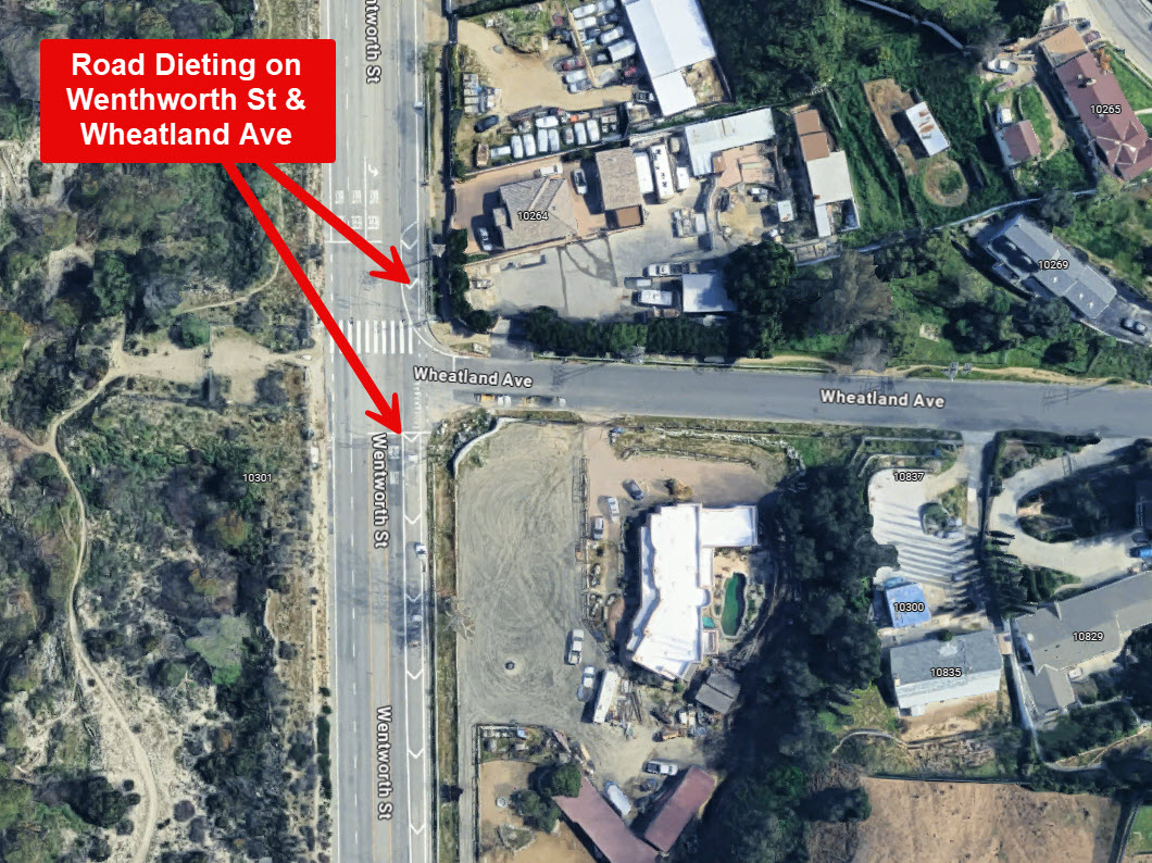
- Reconfigure the roadway (“road diet”) for approximately 1,000 feet before and after the Sunland/Wheatland intersection, reducing to one through lane per direction with dedicated left-turn pockets and pedestrian refuge islands. This is similar to the “road dieting” done on another dangerous street – Wentworth St.
- Install the planned signalized traffic light at the intersection of Johanna Ave and Sunland Blvd.
- Install raised median lanes and candlestick delineators along the curve and commercial segments to prevent crossover collisions and improve visual separation between travel lanes.
LEGAL AND POLICY FRAMEWORK
This stretch of road is no longer just a commuter corridor. It is lined with:
- Businesses at Wheatland — 7-Eleven, Rise N Shine Café, Sun Space Performing Arts Theatre, Seward Real Estate, a pharmacy, a liquor store with offices above, and two multi-unit office/retail buildings, as well as Westco Service Company.
- Sensitive facilities — The Hills Healthcare Center (67-bed skilled nursing), Tierra del Sol Foundation for individuals with disabilities, a licensed family day care, senior housing, equestrian activity, and several bus stops serving the corridor.
- Beyond these statutes, simple common sense and years of accident data show that this corridor remains one of the most dangerous in the region. Unless corrective action is taken immediately, another major property-damage or fatal accident is highly likely.
1. AB 43 (2021–2024) – Safe Speed Setting Flexibility
California’s Assembly Bill 43 (Vehicle Code §§ 22358.6–22358.9) empowers local jurisdictions to set safer, context-based speed limits. It allows for:
- Safety Corridor designation: allows cities to lower limits in Safety Corridors (§22358.7 VC), Business Activity Districts (§22358.9 VC), or retain prior lower limits (§22358.8 VC). Sensitive users (children, seniors, disabled) may be explicitly considered. Specifically, City may reduce by an extra 5 mph where severe crash history is present.
Business Activity Districts: Corridors with retail, crosswalks, and pedestrian activity may be posted at 25 mph or lower.
Consider vulnerable users: E&TS may weigh pedestrians, cyclists, children, seniors, and disabled residents.
Given its crash record, mixed land uses, and the presence of vulnerable road users, Sunland Boulevard qualifies for immediate speed-limit reduction under AB 43.
2. AB 645 (2023) – Speed Safety Camera Pilot
Under Assembly Bill 645, Los Angeles is authorized to install up to 125 automated speed-enforcement cameras beginning in 2026. Priority corridors are those with:
A high rate of speed-related collisions, Schools, senior facilities, or commercial centers, and documented excessive speeding beyond posted limits. Sunland Boulevard meets every one of these criteria.
- It includes a 67-bed skilled-nursing facility,
- A disability-support center (Tierra del Sol Foundation),
- Childcare,
- Equestrian trails, and;
- A high-injury collision history, including the 2022 Sunland Place crash that resulted in a $500,000 City settlement (Arbi Mangasar v. City of Los Angeles, Council File 25-0552).
3. MUTCD and FHWA Standards
The California Manual on Uniform Traffic Control Devices (CA-MUTCD) requires advance warning signs, including “Curve,” “Signal Ahead,” and “Reduced Speed Ahead” where roadway geometry limits sight distance (§ 2C.06–2C.37).
The Federal Highway Administration (FHWA) lists road diets as a proven safety countermeasure, with research showing 19–47 percent crash reductions on similar four-lane roadways converted to three lanes with center turn pockets and pedestrian refuges.
CLOSING
Sunland Boulevard has outlived the era it was built for. Designed more than a century ago as a rural connector, it now cuts through a thriving community of homes, schools, businesses, and equestrian trails, yet it is still governed by the speed standards of another time. The result is a street that has become dangerously incompatible with the life around it. What was once an access road for orchards now serves as a 45-mph high-speed corridor through a residential neighborhood, where children walk, mail is delivered, trash is collected, and heavy trucks race past storefronts and driveways.
The evidence is no longer theoretical, it is visible in the shattered guardrails, broken fences, destroyed mailboxes, and the growing list of collisions and injuries, including those that have already cost the City financially and put lives at risk. With population and traffic volumes rising, and new businesses opening at every corner, inaction is no longer an option.
We therefore urge the City to act immediately: install a road diet at the only business corner in shadow hills, reduce the speed limit, install proper signage and speed safety cameras, and enforce the standards that protect the people of this community. Every day that passes without intervention increases the likelihood of another preventable tragedy. Sunland Boulevard must not claim another life before change begins.
Thank you for your attention and leadership on this critical safety issue. We remain ready to meet with your staff, provide supporting data, and walk the corridor together to see firsthand what our community faces every day.
Respectfully,
Residents & Businesses of Shadow Hills


707
The Issue
We, the undersigned residents and business owners of Shadow Hills, write to the City of Los Angeles Department of Transportation and City Authorities to express our deep concern regarding the ongoing traffic dangers on Sunland Boulevard between Stonehurst Avenue and the I-210 Freeway, with particular focus on the eastbound curve leading to the intersection at Sunland Boulevard and Wheatland Avenue.
Although this section is posted at 45 mph, the reality on the ground is far different. Drivers routinely travel at 55 to 75 mph, turning what should be a calm, mixed-use community corridor into a high-speed thoroughfare. In addition to passenger vehicles, large commercial trucks and heavy haulers thunder through the business section at 45–55 mph, generating deafening air noise and ground vibration that shakes nearby buildings and rattles windows as if the entire street is experiencing a miniature earthquake.
The constant roar and shock waves from these trucks make ordinary daily life working in nearby offices, sitting at local restaurants and cafes, or simply standing on the sidewalk, feel unsafe and unsettling. The U.S. Postal Service delivers mail daily along this same stretch, and trash trucks regularly stop to collect from homes and businesses, forcing them to share the roadway with speeding traffic.
Ironically, the boulevard is virtually empty 90% of the time, leaving enormous, unused pavement that only encourages higher speeds. Despite repeated community complaints, there have been frequent collisions, near-misses, and serious injuries, including three major crashes within a single week in May 2025. The combination of high-speed traffic, low usage, and unchecked truck activity has turned this section of Sunland Boulevard into a dangerous and deeply disruptive environment for the community that lives and works along it.
The boulevard is missing critical traffic safety signs and warnings, including curve advisories, reduced speed notifications, and “Traffic Signal Ahead” alerts. The roadway itself presents restricted visibility, sharp horizontal and vertical curvature, and numerous hidden driveways, all compounded by dense shrubbery extending to the curb line, which often forces pedestrians, cyclists, and even equestrian riders into the roadway.
Although partial guardrails were installed to protect property at some segments, there remains no raised median, no consistent signage, and no speed reduction to protect human life. The entire length of Sunland Boulevard includes active equestrian trails, making these design and visibility issues even more dangerous. Furthermore, there have been numerous unreported or undocumented accidents, which seem to have prevented the City from fully recognizing the extent of the hazard and taking appropriate corrective action.
RECENT MAJOR ACCIDENT AND CITY LIABILITY (Motion Item No.78)
On March 13, 2022, a severe vehicle collision occurred at the Sunland Boulevard and Sunland Place curve, resulting in serious injuries and significant property damage.
This incident led to the case Arbi Mangasar v. City of Los Angeles (Los Angeles Superior Court No. 23BBCV00736). On July 30, 2025, the Los Angeles City Council approved a $500,000 payment in this matter (Council File 25-0552), paid from the City’s Transportation Liability Fund.
This public record confirms that the City has already incurred substantial liability due to dangerous roadway conditions on Sunland Boulevard. The same segment remains largely unchanged today lacking curve warnings, advisory speed signage, median protection, or advance signal warnings leaving residents and drivers exposed to the same risks that triggered the 2022 crash.
TRAFFIC CONDITIONS AND SAFETY HAZARDS
The steep curve west of Wheatland Avenue along Sunland Boulevard leading to the commercial intersection is one of the most dangerous segments on this road. It lacks any curve-warning signs, advisory-speed plaques, or “Traffic Signal Ahead” signage. As a result, eastbound drivers are often surprised by the signal and accelerate to beat the light, creating frequent high-speed conflicts. Numerous driveways and cross-streets along this stretch require vehicles to slow or turn abruptly into fast-moving traffic.
Despite these hazards, Sunland Boulevard is significantly underutilized for its width and lane configuration. This excess capacity invites speeding by both passenger vehicles and heavy commercial trucks, turning the corridor into an informal high-speed zone.
There is ample room to reduce speeds, reconfigure lanes, and implement safety measures without causing congestion or impeding traffic flow. A proper traffic and engineering study will confirm this and provide the data needed to support these changes.
Over the years, these design deficiencies have resulted in broken guardrails, damaged equestrian fencing, multiple injury-causing accidents, and even the destruction of the U.S. Postal Service mailbox at the 7-Eleven plaza. Local businesses have witnessed dozens of collisions and hundreds of near-misses.
The access driveway to the commercial plaza housing 7-Eleven is located immediately after the intersection, where vehicles traveling at 60 mph or more are often caught off guard by drivers slowing or stopping, sometimes without turn signals, to enter the plaza. Just beyond the steep curve lies another new commercial plaza, requiring a sharp 90-degree turn into its driveway. There is critically low visibility for speeding drivers to recognize slowed or stopped vehicles, postal and trash service vehicles, or buses ahead. Together, these conditions create a life-threatening environment for motorists, pedestrians, and equestrians alike.
CRITICALLY DANGEROUS SEGMENT. VISIBILITY BELOW MINIMUM AASHTO STANDARDS
On the west side of Wheatland Avenue along Sunland Boulevard, eastbound drivers encounter a steep curve immediately followed by a driveway located approximately 250 feet beyond the curve. This driveway serves a newly constructed commercial plaza with active daily traffic and an existing residential property, requiring a nearly 90-degree turn from the main roadway.
The available sight distance of roughly 250 feet falls far short of the minimum 360 feet required at the posted 45 mph speed under AASHTO and Caltrans design standards for stopping sight distance.
This means that a driver traveling at the current speed limit cannot safely perceive and react to a vehicle turning into or exiting this driveway in time to stop. The situation is even more dangerous for large trucks or delivery vehicles, which need more than 400 feet to stop. Reducing the speed limit to 35 mph would bring this segment into compliance with safety standards, as that speed aligns with the available 250-foot visibility. Immediate speed reduction, “Hidden Driveway” warning signage, and advance curve and signal warnings are critical to prevent serious collisions at this location.
HISTORICAL AND PLANNING CONTEXT
Sunland Boulevard was originally constructed in 1907, along with neighboring Wentworth Street, to serve the early Sunland–Tujunga agricultural settlements. At the time, these roads traversed open farmland and olive orchards, designed primarily for automobile access between the foothill communities and the San Fernando Valley. There was little to no roadside development or pedestrian activity for many decades.
The Sunland and Wheatland intersection remained mostly undeveloped until the 1950s, when the first buildings appeared at the northeast and southwest corners. Over subsequent decades, the intersection gradually evolved into a commercial and mixed-use hub serving the growing community:
- The current 7-Eleven building (southeast corner) was built in the 1960s, with the 7-Eleven store opening in 2010.
The liquor store and second-floor offices at the northwest corner were built in 2012, including a Pilates studio and other professional tenants generating daily foot and vehicle traffic. - A 6,000-square-foot commercial and retail building was constructed at the southwest corner in 2025, introducing new businesses and a dedicated equestrian trail along the frontage.
- A large pharmacy is currently under construction at the northeast corner, and it is expected to further increase vehicle turning movements, parking demand, and pedestrian crossings.
These cumulative developments have turned what was once a quiet rural corridor into an active, high-traffic business district with constant interaction between motorists, pedestrians, and equestrians.
Despite this transformation, the posted 45-mph speed limit remains based on conditions from traffic studies dating back to 2009. The City of Los Angeles Department of Transportation (LADOT) report dated August 13, 2009, recommended retaining the 45-mph limit based on an accident rate of 0.93 per million vehicle miles and a critical speed of 41.5 mph, referencing only “small businesses near Wheatland Avenue.”
A subsequent LADOT Board report of July 24, 2012 noted that the speed zone survey between Foothill and Vineland was already expired, yet no new study was completed.
Since those reports, both population and traffic volumes have increased substantially:
- The population of Shadow Hills grew from 13,098 in 2008 (per Los Angeles Times, Mapping L.A.) to approximately 14,800 in 2025 (per Niche.com), a rise of over 13 percent.
- The City’s own 24-hour traffic volume count for Sunland Boulevard shows an increase from 11,500 vehicles per day to an estimated 13,500 vehicles per day currently, a gain of nearly 2,000 daily trips, excluding the added impact of new commercial projects.
Taken together, these factors demonstrate that the existing 45-mph speed limit is obsolete and inconsistent with current traffic demand and land use. The corridor has evolved from a rural arterial into a densely active mixed-use street, yet the City continues to rely on pre-development data more than a decade old. Modernizing the speed study and safety infrastructure here is not merely advisable — it is necessary to bring Sunland Boulevard into alignment with its present-day function and the safety needs of its residents.
OUR REQUESTS
We respectfully ask that the City take immediate and coordinated action to address the well-documented dangers on Sunland Boulevard. The primary need on Sunland Boulevard is not increased capacity, but increased control. Enforcement, warning systems, and speed management are the missing elements that will save lives. The following steps are urgently needed to protect public safety and prevent further injury, property damage, or loss of life:
- Conduct a new, comprehensive traffic and safety study for the Sunland Boulevard corridor, an assessment that is long overdue given the crash history, increased commercial density, and changing community use.
- Reduce the posted speed limit from 45 mph to 40 mph under AB 43 authority, with evaluation for 35 mph corridor-wide and 25 mph within the Wheatland business zone, consistent with Safety Corridor and Business Activity District provisions.
- Implement immediate interim safety measures, including speed-feedback signs, high-visibility crosswalks, daylighting and curb extensions, leading pedestrian intervals, and “No Turn on Red” restrictions where appropriate.
- Install proper warning signage, such as curve-warning signs with advisory-speed plaques, “Traffic Signal Ahead” signs, and blinking beacons on the west-to-east approach to Wheatland Avenue.
- Include Sunland Boulevard in the 2026 AB 645 Speed Safety Camera Pilot Program to curb chronic speeding and improve driver compliance. A major contributor to Sunland Boulevard’s risk profile is the absence of consistent traffic enforcement. Residents report that speed monitoring by LAPD or LADOT is sporadic and limited to a few morning hours, while speeding occurs around the clock. Automated speed-enforcement cameras under AB 645 would provide a reliable, objective, and continuous deterrent to dangerous driving behavior.
- Reconfigure the roadway (“road diet”) for approximately 1,000 feet before and after the Sunland/Wheatland intersection, reducing to one through lane per direction with dedicated left-turn pockets and pedestrian refuge islands. This is similar to the “road dieting” done on another dangerous street – Wentworth St.
- Install the planned signalized traffic light at the intersection of Johanna Ave and Sunland Blvd.
- Install raised median lanes and candlestick delineators along the curve and commercial segments to prevent crossover collisions and improve visual separation between travel lanes.
LEGAL AND POLICY FRAMEWORK
This stretch of road is no longer just a commuter corridor. It is lined with:
- Businesses at Wheatland — 7-Eleven, Rise N Shine Café, Sun Space Performing Arts Theatre, Seward Real Estate, a pharmacy, a liquor store with offices above, and two multi-unit office/retail buildings, as well as Westco Service Company.
- Sensitive facilities — The Hills Healthcare Center (67-bed skilled nursing), Tierra del Sol Foundation for individuals with disabilities, a licensed family day care, senior housing, equestrian activity, and several bus stops serving the corridor.
- Beyond these statutes, simple common sense and years of accident data show that this corridor remains one of the most dangerous in the region. Unless corrective action is taken immediately, another major property-damage or fatal accident is highly likely.
1. AB 43 (2021–2024) – Safe Speed Setting Flexibility
California’s Assembly Bill 43 (Vehicle Code §§ 22358.6–22358.9) empowers local jurisdictions to set safer, context-based speed limits. It allows for:
- Safety Corridor designation: allows cities to lower limits in Safety Corridors (§22358.7 VC), Business Activity Districts (§22358.9 VC), or retain prior lower limits (§22358.8 VC). Sensitive users (children, seniors, disabled) may be explicitly considered. Specifically, City may reduce by an extra 5 mph where severe crash history is present.
Business Activity Districts: Corridors with retail, crosswalks, and pedestrian activity may be posted at 25 mph or lower.
Consider vulnerable users: E&TS may weigh pedestrians, cyclists, children, seniors, and disabled residents.
Given its crash record, mixed land uses, and the presence of vulnerable road users, Sunland Boulevard qualifies for immediate speed-limit reduction under AB 43.
2. AB 645 (2023) – Speed Safety Camera Pilot
Under Assembly Bill 645, Los Angeles is authorized to install up to 125 automated speed-enforcement cameras beginning in 2026. Priority corridors are those with:
A high rate of speed-related collisions, Schools, senior facilities, or commercial centers, and documented excessive speeding beyond posted limits. Sunland Boulevard meets every one of these criteria.
- It includes a 67-bed skilled-nursing facility,
- A disability-support center (Tierra del Sol Foundation),
- Childcare,
- Equestrian trails, and;
- A high-injury collision history, including the 2022 Sunland Place crash that resulted in a $500,000 City settlement (Arbi Mangasar v. City of Los Angeles, Council File 25-0552).
3. MUTCD and FHWA Standards
The California Manual on Uniform Traffic Control Devices (CA-MUTCD) requires advance warning signs, including “Curve,” “Signal Ahead,” and “Reduced Speed Ahead” where roadway geometry limits sight distance (§ 2C.06–2C.37).
The Federal Highway Administration (FHWA) lists road diets as a proven safety countermeasure, with research showing 19–47 percent crash reductions on similar four-lane roadways converted to three lanes with center turn pockets and pedestrian refuges.
CLOSING
Sunland Boulevard has outlived the era it was built for. Designed more than a century ago as a rural connector, it now cuts through a thriving community of homes, schools, businesses, and equestrian trails, yet it is still governed by the speed standards of another time. The result is a street that has become dangerously incompatible with the life around it. What was once an access road for orchards now serves as a 45-mph high-speed corridor through a residential neighborhood, where children walk, mail is delivered, trash is collected, and heavy trucks race past storefronts and driveways.
The evidence is no longer theoretical, it is visible in the shattered guardrails, broken fences, destroyed mailboxes, and the growing list of collisions and injuries, including those that have already cost the City financially and put lives at risk. With population and traffic volumes rising, and new businesses opening at every corner, inaction is no longer an option.
We therefore urge the City to act immediately: install a road diet at the only business corner in shadow hills, reduce the speed limit, install proper signage and speed safety cameras, and enforce the standards that protect the people of this community. Every day that passes without intervention increases the likelihood of another preventable tragedy. Sunland Boulevard must not claim another life before change begins.
Thank you for your attention and leadership on this critical safety issue. We remain ready to meet with your staff, provide supporting data, and walk the corridor together to see firsthand what our community faces every day.
Respectfully,
Residents & Businesses of Shadow Hills
The Decision Makers


Supporter Voices
Petition Updates
Share this petition
Petition created on October 16, 2025