
UPHOLD THE 1998 SECTOR PLAN FOR PARCEL 4 IN THE VILLAGE OF FRIENDSHIP HEIGHTS
UPHOLD THE 1998 SECTOR PLAN FOR PARCEL 4 IN THE VILLAGE OF FRIENDSHIP HEIGHTS
The Issue
WARNING!
150-ft High-Rise Zoning Change Proposed for the Village of Friendship Heights on Parcel 4 ACROSS from the WILLOUGHBY North
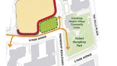
Parcel 4 is located at 5550 Friendship Boulevard, at the corner of N. Park Avenue and Friendship Boulevard across from the Willoughby North, the Village Center, and a senior living community. The 1998 Sector Plan designated its frontage as Parks & Open Space and called for mid-rise — not high-rise — development. The proposed zoning change would:
- abandon the 1998 Sector Plan’s Parks & Open Space designation for this frontage — replacing the green lawn and mature trees that today front the full corridor with a 0.5-acre POPS confined to one corner of the parcel.
- replace the open green space with a tiny micro-lawn at the intersection of N. Park Avenue and Friendship Boulevard — creating new pedestrian challenge points at an already dangerous crossing used daily by elderly residents and people with mobility impairments, with no pedestrian safety analysis presented.
- increase the footprint of the building on the site and far exceed the mid-rise scale the 1998 plan recommended, blocking views and casting shadow on residents of The Willoughby’s North Building.
- eliminate mature trees and create an urban canyon on N. Park Avenue and Friendship Boulevard, in a neighborhood already critically short of green space.
We, the undersigned stakeholders of Friendship Heights, MD, call on the Montgomery County Planning Board to commit to preserving the key tenets of the 1998 Sector Plan for Parcel 4 (5550 Friendship Boulevard) in the Village of Friendship Heights, Maryland:
A commitment to the meaningful green open space the 1998 Sector Plan called for. The 1998 Sector Plan designated the Parcel 4 frontage as Parks & Open Space. That designation is reflected in the green lawn and mature trees that today front the full length of N. Park Avenue and Friendship Boulevard, used daily by Village residents. The new proposed 0.5-acre patch of green that confined to one corner of the 2.12-acre parcel does not meet that standard and is wholly inadequate alongside a 150-foot tower. The Sector Plan update must protect and formalize that open space — not abandon it.
A commitment to scale consistent with the 1998 Sector Plan. The 1998 Sector Plan recommended a mid-rise residential structure for Parcel 4 and established as a core principle “Preserve and enhance the environment for residents of high-rise buildings” — achieved by limiting the height of new buildings close to existing high-rise residences to preserve views. A proposed height of 150 feet far exceeds the plan’s recommendation and would cast shadow along N. Park Avenue, eliminating views and creating an urban canyon .
A commitment to pedestrian safety, not new hazards. The existing office building already generates traffic that makes it difficult for pedestrians — including many senior citizens — to safely cross intersections in the Village. The proposed design routes pedestrians around a corner POPS (privately owned public space) at the intersection of N. Park Avenue and Friendship Boulevard, creating new conflict points at an already dangerous crossing. No pedestrian safety analysis of this design has been presented. Any redevelopment must improve conditions at this intersection for a population that is disproportionately elderly and includes residents with mobility impairments.
The Village of Friendship Heights has a population density of over 90,000 per square mile — one of the highest in the United States — with 32.4% of residents aged 65 or older and 26.8% of households a senior living alone. Preservation of green, open space is essential to quality of life here. We residents therefore call on the Planning Board to uphold the 1998 Sector Plan’s principles for Parcel 4.
June 2026

36
The Issue
WARNING!
150-ft High-Rise Zoning Change Proposed for the Village of Friendship Heights on Parcel 4 ACROSS from the WILLOUGHBY North
Parcel 4 is located at 5550 Friendship Boulevard, at the corner of N. Park Avenue and Friendship Boulevard across from the Willoughby North, the Village Center, and a senior living community. The 1998 Sector Plan designated its frontage as Parks & Open Space and called for mid-rise — not high-rise — development. The proposed zoning change would:
- abandon the 1998 Sector Plan’s Parks & Open Space designation for this frontage — replacing the green lawn and mature trees that today front the full corridor with a 0.5-acre POPS confined to one corner of the parcel.
- replace the open green space with a tiny micro-lawn at the intersection of N. Park Avenue and Friendship Boulevard — creating new pedestrian challenge points at an already dangerous crossing used daily by elderly residents and people with mobility impairments, with no pedestrian safety analysis presented.
- increase the footprint of the building on the site and far exceed the mid-rise scale the 1998 plan recommended, blocking views and casting shadow on residents of The Willoughby’s North Building.
- eliminate mature trees and create an urban canyon on N. Park Avenue and Friendship Boulevard, in a neighborhood already critically short of green space.
We, the undersigned stakeholders of Friendship Heights, MD, call on the Montgomery County Planning Board to commit to preserving the key tenets of the 1998 Sector Plan for Parcel 4 (5550 Friendship Boulevard) in the Village of Friendship Heights, Maryland:
A commitment to the meaningful green open space the 1998 Sector Plan called for. The 1998 Sector Plan designated the Parcel 4 frontage as Parks & Open Space. That designation is reflected in the green lawn and mature trees that today front the full length of N. Park Avenue and Friendship Boulevard, used daily by Village residents. The new proposed 0.5-acre patch of green that confined to one corner of the 2.12-acre parcel does not meet that standard and is wholly inadequate alongside a 150-foot tower. The Sector Plan update must protect and formalize that open space — not abandon it.
A commitment to scale consistent with the 1998 Sector Plan. The 1998 Sector Plan recommended a mid-rise residential structure for Parcel 4 and established as a core principle “Preserve and enhance the environment for residents of high-rise buildings” — achieved by limiting the height of new buildings close to existing high-rise residences to preserve views. A proposed height of 150 feet far exceeds the plan’s recommendation and would cast shadow along N. Park Avenue, eliminating views and creating an urban canyon .
A commitment to pedestrian safety, not new hazards. The existing office building already generates traffic that makes it difficult for pedestrians — including many senior citizens — to safely cross intersections in the Village. The proposed design routes pedestrians around a corner POPS (privately owned public space) at the intersection of N. Park Avenue and Friendship Boulevard, creating new conflict points at an already dangerous crossing. No pedestrian safety analysis of this design has been presented. Any redevelopment must improve conditions at this intersection for a population that is disproportionately elderly and includes residents with mobility impairments.
The Village of Friendship Heights has a population density of over 90,000 per square mile — one of the highest in the United States — with 32.4% of residents aged 65 or older and 26.8% of households a senior living alone. Preservation of green, open space is essential to quality of life here. We residents therefore call on the Planning Board to uphold the 1998 Sector Plan’s principles for Parcel 4.
June 2026
36
The Decision Makers
Supporter Voices
Petition Updates
Share this petition
Petition created on June 14, 2026