Cenin Cil Lonydd Solar Farm Update
Hi Everyone,
Just a quick update on the recent documents added to the Cenin Solar Farm Development...
NRW have commented on some of the representatios ( Objections ). They touched on mine, 2025-05-01 - FI REPS2 - 003, among others and tried to make out I didn't mention the peat depths saying 'though exact depths are not reported'. This is a lie.
As some of you will know, who have seen the video I sent with my previous Solar Farm objection, I followed the proposed cable route and referenced Peat depths with footage at various locations along the way including some peat depths at the proposed site for the solar panels. These are the depths:-Peat Bog 1-0.4m, 2- 0.5m, 3- 0.425m, 4- 0.5m, 5- 0.4m, 6- 0.475m 7- peat already exposed picture, 8- peat already exposed picture, ( on site- 9- 0.5m, 10- 0.5m 11- 0.6m 12- 0.4m 13- 0.5m ) the on site depths were in the area the developer refers to as 'Marshy', they rather say that, than avoid mentioning the peat. The area holds water because of the large presence of peat, whether they want to acknowledge it or not.
This seems to be the theme of these developments - Ignoring the obvious and touching on any potential reasons these developments may be stopped with 'child like' responses. Such as the use of snffer dogs to search for Bats with the Trecelyn wind Farm, moving turbines 50m for the birds present at the sites? As if the birds don't fly any further than 50m?
In the recent RES objection I sent a video again showing Peat Depths at turbine locations and the proposed substation area- (the same one the Solar farm intends to share with RES) Starting at a peat bog in the substation area, Then 1- 0.5m 2- 0.55m 3- 0.45m 4- 0.575m 5- 0.475m 6- 0.45m
I included some footage of some skylarks so PEDW can't pretend the birds are not at these locations. I was then approached by PEDW and told they couldn't accept the video under claims of 'sensitivity'? I then had to edit the video and send them one without the birds. I also added pictures of various birds of prey to the pdf, all pictured around the mountain, with no reference to their exact location, only that they were taken in the mountain area. Again this was promptly 'blacked out' from public view before being added to the PEDW casework website. All this but when the developers mention the birds on site areas, such as the solar farm site or RES areas with so called 'mitigation measures' to deal with them, such as 50m zones, PEDW accept this as ok for them to do it?
If PEDW genuinely cared about the wildlife at these sites, then the developments would have been refused along time ago. After all, the wildlife and Birds are under threat because of their end decisions.
There is a bid to contain the true information relating to the areas of this mountain and keep a lid on it from the public. PEDW have had over 7 months, with the Cenin Solar FARM development alone, to question in detail all of these points and fully view objections and there is no excuses for avoiding footage and photos people have sent as proof. PEDW also refused to accept peat measurements I referenced in my video submitted for this recent solar farm objection. I added them because NRW were ignoring them. I removed the video in question as PEDW requested but as yet they have not added my pdf objection...This maybe because I touched on other topics in their new uploaded document:- 2025-06-25 - Response to Peat Resources and their Management
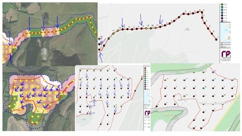
In this The developer has re -submitted the same fake phase 1 peat probing report and this time there are a few new maps that have been added to it that contradicts the first part of the map reports. The areas I have highlighted in the (maps above), with blue arrows, show even lower peat depths to their orignal peat depth maps and again with no coordinates as it's all clearly fabricated.
When it comes to the main details, of course, we still don't have the developers homes supplied estimation calculations (for any of the developments?), the carbon debt details and little focus of the mines located under large areas of the site ? ( Marked in Grey cross lines in map above bottom right)
It's as if the people involved have all been instructed to get these developments through no matter what!
One thing we do know, all these developments are guaranteed Curtailment money!
Many Thanks for now! Matt