

Realign Essendon West suburb boundary to Aberfeldie
The issue
9/6/2025
Dear Neighbour
Re: Suburb Boundary Realignment from Essendon West to Aberfeldie
I write to gain your support to petition Moonee Valley City Council to ratify the proposed renaming of the existing residences currently named within the suburb of Essendon West that are bounded by the un-named storm water creek to the west of Clydebank Road, Buckley Street, Beatrice Avenue west and Afton Street west. This area consists of approximately 84 residencies.
Specifically, the proposed realignment pertains to the properties included within and bounded by the following roadways, features or landmarks as denoted within figures 1 and 2:
· Properties including 445-451 Buckley Street, Essendon West bounded by Clydebank Road to the West, Beatrice Avenue to the East and Buckley Street to the North
· All properties fronting Clydebank Road
· All properties fronting Smilie Crescent
· All properties west of Afton Street (including 32-56), south of Ramsey Street
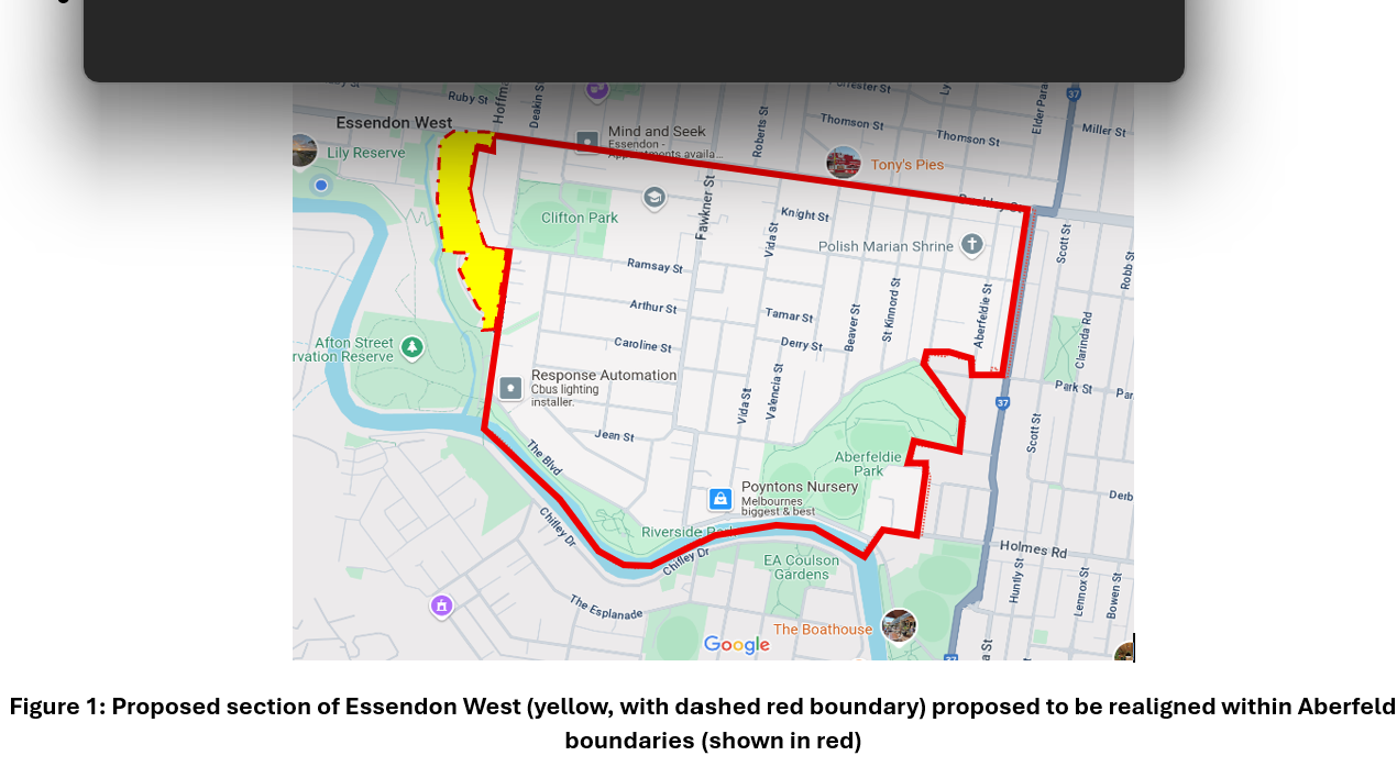
Figure 1: Proposed section of Essendon West (yellow, with dashed red boundary) proposed to be realigned within Aberfeldie boundaries (shown in red)
Benefits
1. Improved, common-sense alignment of the boundary to match natural landmarks to the west, and the arterial road to the north for community, visitors and emergency services.
2. Minimal impact to postal services, with Essendon West and Aberfeldie already sharing the same 3040 postcode.
3. Increased (subjective) prestige for your property, including immediate potential median house price uplift. For June 2024 to May 2025 as reported by Realestate.com.au, Aberfeldie median house is $2,010,000. Houses in Essendon West, in contrast, have a median house price of $1,612,500, representing a median value difference of ~$400K. Rates would increase by the current capital improved value increase. Based on your property having the above median increase by the council’s valuer, which is typically less than market value, this may be not more $177 per quarter, though is anticipated to be much less. The refinancing opportunity created by the boundary realignment for many property owners could absorb this rate increase. Please seek your own professional legal and financial advice on this matter.
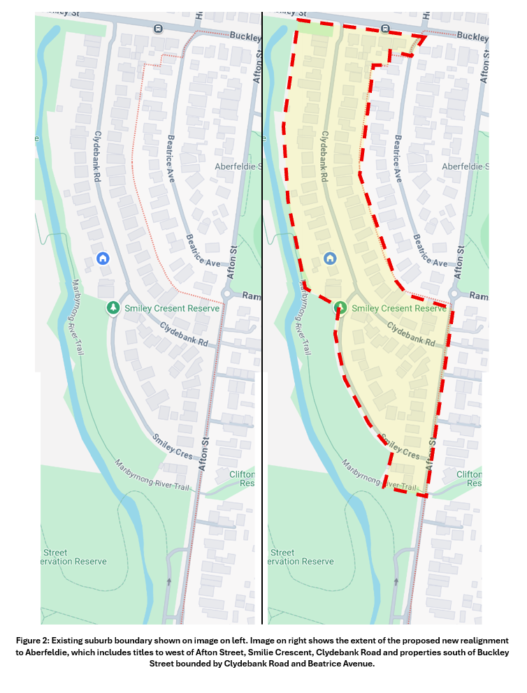
Figure 2: Existing suburb boundary shown on image on left. Image on right shows the extent of the proposed new realignment to Aberfeldie, which includes titles to west of Afton Street, Smilie Crescent, Clydebank Road and properties south of Buckley Street bounded by Clydebank Road and Beatrice Avenue.
Moonee Valley Council’s Place Naming Policy
Within Moonee Valley City Council’s Place Naming Policy Revision 1.0 dated 8 August 2023, the policy notes.
Council, as the responsible Naming Authority under the Naming Rules for places in Victoria 2022, is responsible for geographic place names within its municipality, with the exception of geographic places of regional, state or national significance and water ways.
Appropriate naming is essential to identify locations easily for providing emergency services and delivering goods and services in Victoria.
Council will preserve the heritage and identity of its City's localities and wherever possible, will link the name to the place through the use of the following 'naming themes':
· Recognition of Aboriginal heritage and language;
· Recognition of cultural diversity;
· Notable residents (male and female) who are deceased;
· Location (including suburb locality);
· Significant contributors to the community who are deceased;
· Local flora and fauna;
· Historical exploration and uses of the land and the people associated with it;
· Former veteran personnel and civil servants who are deceased;
· Social and historical events.
Argument 1:
The current boundary alignment is not currently immediately apparent to the community, visitors or emergency services.
History of zone
From Moonee Valley City Council Website:
The Wurundjeri are the original inhabitants. Their last recorded corroboree in the district was held in 1865.
In December 1837, Surveyor Henry Smyth was sent out by the Senior Surveyor of Port Phillip District, Robert Hoddle, to survey the Mone-Mone Creek, a chain of ponds running into a salt water swamp adjoining the western boundary of Melbourne Reserve, with the intention of dividing the land into convenient sections. The land west of the creek was named “Doutta Galla”.
On September 30, 1839, assistant surveyor, David Malcolm Kemp, was instructed, again by Hoddle, to complete the survey of the branches of the Saltwater River (renamed the Maribyrnong River from 1913) and to complete the subdivision of the Parish of Doutta Galla. The Parish was thus divided into twenty-three Sections, each of an area of approximately a square mile (640 acres). These Sections were delineated by Roman numerals commencing at the southern end. Large parcels of land in these sections were sold to early wealthy settlers. Today most of the Parish of Doutta Galla is part of the City of Moonee Valley. Both areas are bordered by the Maribyrnong River and Moonee Ponds Creek. The Parish extended north from the Yarra River and the West Melbourne swamp. The City excludes Kensington and parts of Flemington. East Keilor and Airport West are included in the City’s boundaries.
Local Government arrived in 1861 when the Municipal District of Essendon and Flemington was proclaimed. In 1863, the District would be proclaimed as the Borough of Essendon and Flemington. The residents of Flemington and Kensington would secede from the District in 1882, creating the Borough of Essendon and the Borough of Flemington & Kensington. In 1909, Essendon became a City. The Council met at the Essendon Town Hall from 1886 until 1974 when the Civic Centre on Kellaway Avenue was opened. The City of Essendon merged with part of the City of Keilor in 1994 to become the City of Moonee Valley.
Parish of Doutta Galla, County of Bourke, 1856
The parish map depicts various sub-divisions from modern day Mount Alexander Road to the east, Keilor Road to the North and the Maribyrnong River to the south.
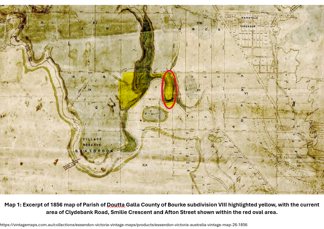
Map 1: Excerpt of 1856 map of Parish of Doutta Galla County of Bourke subdivision VIII highlighted yellow, with the current area of Clydebank Road, Smilie Crescent and Afton Street shown within the red oval area.
Maps of the Parish of Doutta Gala from 1937 show the plot to be within a large plot title owned by J. Aitken plot 8 (previously VIII), immediately adjacent to J. Aitken plots 1 to 5 (I – V), which now make up the majority of modern Aberfeldie.
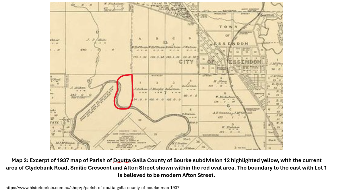
Map 2: Excerpt of 1937 map of Parish of Doutta Galla County of Bourke subdivision 12 highlighted yellow, with the current area of Clydebank Road, Smilie Crescent and Afton Street shown within the red oval area. The boundary to the east with Lot 1 is believed to be modern Afton Street.
https://www.historicprints.com.au/shop/p/parish-of-doutta-galla-county-of-bourke-map-1937
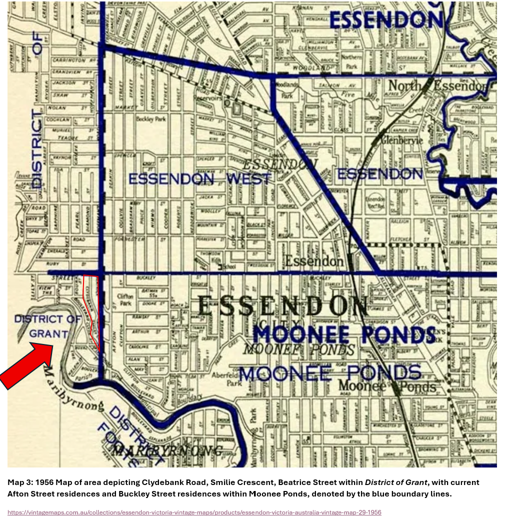
Electoral maps from 1956 show the area to be within the District of Grant, with may previous roads now within the current conservation reserve. The adjacent current suburb of Aberfeldie was at the time Moonee Ponds.
Map 3: 1956 Map of area depicting Clydebank Road, Smilie Crescent, Beatrice Street within District of Grant, with current Afton Street residences and Buckley Street residences within Moonee Ponds, denoted by the blue boundary lines.
Original Land Subdivision May 1920
The plan of subdivision for the corner allotment of section 7 of portion 8 of the Doulla Galla land title clearly shows the establishment of titles within Buckley Street to the north, Afton Street to the East and the creek to the west.
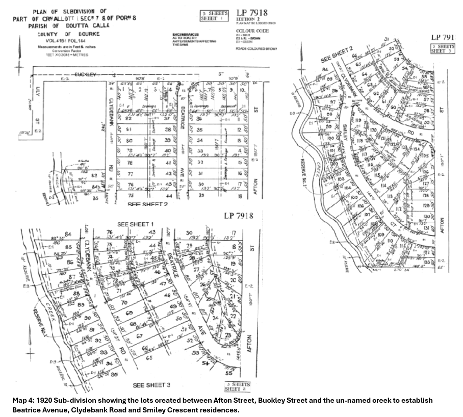
Map 4: 1920 Sub-division showing the lots created between Afton Street, Buckley Street and the un-named creek to establish Beatrice Avenue, Clydebank Road and Smiley Crescent residences.
Argument 3:
The original sub-division of the Doutta Galla Section 8 title created single dwelling properties within Afton Street, Buckley Street and the creek. The proposed suburb realignment for the Clydebank Road, Buckley Street, Smiley Crescent and Afton Street properties reunites these subdivided parcels within the same suburb as the original sub-division intended.
Financial
This section is not financial or legal advice. Seek your own professional financial and legal advice based on your circumstances. Figures and opinions herein are general and the accuracy of the statements is not formed by any qualified professional. There is no consideration of land tax or other possible costs that may be applicable to your circumstances.
Whilst subjective, Aberfeldie as a suburb may present as a more prestigious suburb than Essendon West. With the area being in immediate proximity to the Maribyrnong River, Afton Street Conservation Reserve and south of Buckley Street along with reputable government primary schools and private schools, many many titles also boast a single dwelling covenant. These larger land parcels with an Aberfeldie address are likely to command an immediate land value uplift (when compared to residences with the same suburb name to the east, as opposed to the Essendon West address to the geographical north-west).
The median house price for Aberfeldie (approximately $2M) are almost $400,000 higher than Essendon West (approximately $1.6M), which may result in immediate opportunities:
· Sale value;
· Refinance loans for some property owners based on improved land valuation;
· Improved rental yield potential; and
· Access to additional equity for other investment potential.
Whilst the assumed increase in annual Moonee Valley City Council rates may likely increase at a higher rate for Aberfeldie than Essendon West, the cost may be significantly less than the opportunity cost created for some owners.
The current rate value for ‘Capital Improved Value’ is $0.00177768 for each dollar of the council’s assessed land capital improved value for 2024/2025.
The additional rate uplift is approximately $700. The annual interest rate saving through refinancing an existing loan may exceed this. Under this scenario, your bank may lend you an 80% of the equity increase, or $320,000 based on the median value uplift. This could be used for other investments or renovations.
This section is not financial or legal advice. Seek your own professional financial and legal advice based on your circumstances. Figures and opinions herein are general and the accuracy of the statements is not formed by any qualified professional. There is no consideration of land tax or other possible costs that may be applicable to your circumstances.
Summary
There are no anticipated historical or current policy or legal precedents that may prohibit MVCC agreeing to a suburb boundary realignment petition and ratifying this with Places Victoria. Given the current geographic and bounding titles, there is a common-sense argument for realigning the title, with some possible economic benefits for land holders within the title realignment area.
Please sign the community petition to support the subsequent step (submission to placenaming@mvcc.vic.gov.au)
Sign the petition!
207
The issue
9/6/2025
Dear Neighbour
Re: Suburb Boundary Realignment from Essendon West to Aberfeldie
I write to gain your support to petition Moonee Valley City Council to ratify the proposed renaming of the existing residences currently named within the suburb of Essendon West that are bounded by the un-named storm water creek to the west of Clydebank Road, Buckley Street, Beatrice Avenue west and Afton Street west. This area consists of approximately 84 residencies.
Specifically, the proposed realignment pertains to the properties included within and bounded by the following roadways, features or landmarks as denoted within figures 1 and 2:
· Properties including 445-451 Buckley Street, Essendon West bounded by Clydebank Road to the West, Beatrice Avenue to the East and Buckley Street to the North
· All properties fronting Clydebank Road
· All properties fronting Smilie Crescent
· All properties west of Afton Street (including 32-56), south of Ramsey Street
Figure 1: Proposed section of Essendon West (yellow, with dashed red boundary) proposed to be realigned within Aberfeldie boundaries (shown in red)
Benefits
1. Improved, common-sense alignment of the boundary to match natural landmarks to the west, and the arterial road to the north for community, visitors and emergency services.
2. Minimal impact to postal services, with Essendon West and Aberfeldie already sharing the same 3040 postcode.
3. Increased (subjective) prestige for your property, including immediate potential median house price uplift. For June 2024 to May 2025 as reported by Realestate.com.au, Aberfeldie median house is $2,010,000. Houses in Essendon West, in contrast, have a median house price of $1,612,500, representing a median value difference of ~$400K. Rates would increase by the current capital improved value increase. Based on your property having the above median increase by the council’s valuer, which is typically less than market value, this may be not more $177 per quarter, though is anticipated to be much less. The refinancing opportunity created by the boundary realignment for many property owners could absorb this rate increase. Please seek your own professional legal and financial advice on this matter.
Figure 2: Existing suburb boundary shown on image on left. Image on right shows the extent of the proposed new realignment to Aberfeldie, which includes titles to west of Afton Street, Smilie Crescent, Clydebank Road and properties south of Buckley Street bounded by Clydebank Road and Beatrice Avenue.
Moonee Valley Council’s Place Naming Policy
Within Moonee Valley City Council’s Place Naming Policy Revision 1.0 dated 8 August 2023, the policy notes.
Council, as the responsible Naming Authority under the Naming Rules for places in Victoria 2022, is responsible for geographic place names within its municipality, with the exception of geographic places of regional, state or national significance and water ways.
Appropriate naming is essential to identify locations easily for providing emergency services and delivering goods and services in Victoria.
Council will preserve the heritage and identity of its City's localities and wherever possible, will link the name to the place through the use of the following 'naming themes':
· Recognition of Aboriginal heritage and language;
· Recognition of cultural diversity;
· Notable residents (male and female) who are deceased;
· Location (including suburb locality);
· Significant contributors to the community who are deceased;
· Local flora and fauna;
· Historical exploration and uses of the land and the people associated with it;
· Former veteran personnel and civil servants who are deceased;
· Social and historical events.
Argument 1:
The current boundary alignment is not currently immediately apparent to the community, visitors or emergency services.
History of zone
From Moonee Valley City Council Website:
The Wurundjeri are the original inhabitants. Their last recorded corroboree in the district was held in 1865.
In December 1837, Surveyor Henry Smyth was sent out by the Senior Surveyor of Port Phillip District, Robert Hoddle, to survey the Mone-Mone Creek, a chain of ponds running into a salt water swamp adjoining the western boundary of Melbourne Reserve, with the intention of dividing the land into convenient sections. The land west of the creek was named “Doutta Galla”.
On September 30, 1839, assistant surveyor, David Malcolm Kemp, was instructed, again by Hoddle, to complete the survey of the branches of the Saltwater River (renamed the Maribyrnong River from 1913) and to complete the subdivision of the Parish of Doutta Galla. The Parish was thus divided into twenty-three Sections, each of an area of approximately a square mile (640 acres). These Sections were delineated by Roman numerals commencing at the southern end. Large parcels of land in these sections were sold to early wealthy settlers. Today most of the Parish of Doutta Galla is part of the City of Moonee Valley. Both areas are bordered by the Maribyrnong River and Moonee Ponds Creek. The Parish extended north from the Yarra River and the West Melbourne swamp. The City excludes Kensington and parts of Flemington. East Keilor and Airport West are included in the City’s boundaries.
Local Government arrived in 1861 when the Municipal District of Essendon and Flemington was proclaimed. In 1863, the District would be proclaimed as the Borough of Essendon and Flemington. The residents of Flemington and Kensington would secede from the District in 1882, creating the Borough of Essendon and the Borough of Flemington & Kensington. In 1909, Essendon became a City. The Council met at the Essendon Town Hall from 1886 until 1974 when the Civic Centre on Kellaway Avenue was opened. The City of Essendon merged with part of the City of Keilor in 1994 to become the City of Moonee Valley.
Parish of Doutta Galla, County of Bourke, 1856
The parish map depicts various sub-divisions from modern day Mount Alexander Road to the east, Keilor Road to the North and the Maribyrnong River to the south.
Map 1: Excerpt of 1856 map of Parish of Doutta Galla County of Bourke subdivision VIII highlighted yellow, with the current area of Clydebank Road, Smilie Crescent and Afton Street shown within the red oval area.
Maps of the Parish of Doutta Gala from 1937 show the plot to be within a large plot title owned by J. Aitken plot 8 (previously VIII), immediately adjacent to J. Aitken plots 1 to 5 (I – V), which now make up the majority of modern Aberfeldie.
Map 2: Excerpt of 1937 map of Parish of Doutta Galla County of Bourke subdivision 12 highlighted yellow, with the current area of Clydebank Road, Smilie Crescent and Afton Street shown within the red oval area. The boundary to the east with Lot 1 is believed to be modern Afton Street.
https://www.historicprints.com.au/shop/p/parish-of-doutta-galla-county-of-bourke-map-1937
Electoral maps from 1956 show the area to be within the District of Grant, with may previous roads now within the current conservation reserve. The adjacent current suburb of Aberfeldie was at the time Moonee Ponds.
Map 3: 1956 Map of area depicting Clydebank Road, Smilie Crescent, Beatrice Street within District of Grant, with current Afton Street residences and Buckley Street residences within Moonee Ponds, denoted by the blue boundary lines.
Original Land Subdivision May 1920
The plan of subdivision for the corner allotment of section 7 of portion 8 of the Doulla Galla land title clearly shows the establishment of titles within Buckley Street to the north, Afton Street to the East and the creek to the west.
Map 4: 1920 Sub-division showing the lots created between Afton Street, Buckley Street and the un-named creek to establish Beatrice Avenue, Clydebank Road and Smiley Crescent residences.
Argument 3:
The original sub-division of the Doutta Galla Section 8 title created single dwelling properties within Afton Street, Buckley Street and the creek. The proposed suburb realignment for the Clydebank Road, Buckley Street, Smiley Crescent and Afton Street properties reunites these subdivided parcels within the same suburb as the original sub-division intended.
Financial
This section is not financial or legal advice. Seek your own professional financial and legal advice based on your circumstances. Figures and opinions herein are general and the accuracy of the statements is not formed by any qualified professional. There is no consideration of land tax or other possible costs that may be applicable to your circumstances.
Whilst subjective, Aberfeldie as a suburb may present as a more prestigious suburb than Essendon West. With the area being in immediate proximity to the Maribyrnong River, Afton Street Conservation Reserve and south of Buckley Street along with reputable government primary schools and private schools, many many titles also boast a single dwelling covenant. These larger land parcels with an Aberfeldie address are likely to command an immediate land value uplift (when compared to residences with the same suburb name to the east, as opposed to the Essendon West address to the geographical north-west).
The median house price for Aberfeldie (approximately $2M) are almost $400,000 higher than Essendon West (approximately $1.6M), which may result in immediate opportunities:
· Sale value;
· Refinance loans for some property owners based on improved land valuation;
· Improved rental yield potential; and
· Access to additional equity for other investment potential.
Whilst the assumed increase in annual Moonee Valley City Council rates may likely increase at a higher rate for Aberfeldie than Essendon West, the cost may be significantly less than the opportunity cost created for some owners.
The current rate value for ‘Capital Improved Value’ is $0.00177768 for each dollar of the council’s assessed land capital improved value for 2024/2025.
The additional rate uplift is approximately $700. The annual interest rate saving through refinancing an existing loan may exceed this. Under this scenario, your bank may lend you an 80% of the equity increase, or $320,000 based on the median value uplift. This could be used for other investments or renovations.
This section is not financial or legal advice. Seek your own professional financial and legal advice based on your circumstances. Figures and opinions herein are general and the accuracy of the statements is not formed by any qualified professional. There is no consideration of land tax or other possible costs that may be applicable to your circumstances.
Summary
There are no anticipated historical or current policy or legal precedents that may prohibit MVCC agreeing to a suburb boundary realignment petition and ratifying this with Places Victoria. Given the current geographic and bounding titles, there is a common-sense argument for realigning the title, with some possible economic benefits for land holders within the title realignment area.
Please sign the community petition to support the subsequent step (submission to placenaming@mvcc.vic.gov.au)
Sign the petition!
The Decision Makers
Petition Updates
Share this petition
Petition created on 9 June 2025