

Protect Moore's Creek Flood Plain - AGAIN!
The Issue
What’s happening?
In June 2025, the Board of Supervisors denied a request to dump fill in the Moore’s Creek floodplain.
The developer is back with a revised plan: 4 buildings + parking on a site zoned Light Industrial (not residential, not mixed-use).
The developer is already approved for and building 160,000 sq feet of light industrial space on the steep slope that drains into this flood plain and into Moore's Creek, which outlets into the Rivanna just beyond the Woolen Mills.
Planning Commission meets Tuesday, Dec. 16 at 6 PM (Lane Auditorium, 401 McIntire Rd). Final vote: Jan. 14, 2026
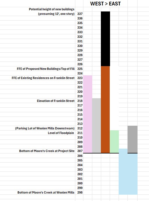
Site area: 1.34 acres ≈ 58,370 sq ft
Height difference: 325 ft – 315 ft = 10 ft
Approximate fill volume: 583,704 cubic feet
Equivalent stormwater displacement: ≈ 4.37 million gallons
This is the amount of flood storage lost if the site is raised to 325 ft.
In a high water event, this displaced volume would fill about 6.6 Olympic-sized swimming pools.
*Franklin Street already gets standing water whenever it rains*
12/16/25, Tuesday night, at 6:00 p.m. the Albemarle County Planning Commission will discuss this special use permit floodplain fill request again. The (human) population that will be most subject to the negative externalities of the potential light industrial development of this site are the residents of the Carlton Mobile Home Park purchased by Habitat for Humanity and the three homes within 300 feet of the proposed entrance, two of which date to ca. 1920. It is also adjacent to a 4 acre Environmental Conservation Area that would be negatively impacted.
Want to help us push back?
- Sign this petition
- Email your thoughts to the addresses below
- Attend a meeting in person (and speak) – email jennymikulski@gmail.com if you would be interested in coordinating talking points
- Drive to the site and check it out (navigate to 720 Franklin Street and look to the right to see where the developer has already stockpiled fill)… look up to see the same developer’s project on the slope
bos@albemarle.org Albemarle County Board of Supervisors
PlanningCommission@albemarle.org All planning commissioners
mpruitt@albemarle.org Scottsville District Supervisor
fmissel@albemarle.org Fred Missel Scottsville Planning Commissioner
June 4, 2025 Meeting Votes:
Supervisors Ned Gallaway, Diantha McKeel, and Bea LaPisto-Kirtley voted to approve the special use permit.
Supervisors Ann Mallek, Mike Pruitt and Jim Andrews voted to deny it.
✅ Arguments made in support
- Engineering assurances: FEMA “No Rise” certification; county engineers claim negligible impact on flood elevation.
- Zoning compliance: Parcel is LI (Light Industrial); proposal enables reasonable use under existing zoning
- Economic benefits: Supports job creation; aligns with Broadway Blueprint and county’s economic strategic plan; county gets more LI space (which most of Albemarle County isn't zoned for and there is a "need" for)
- Precedent: Similar fill operations approved before (ca. 1990s Carter's Bread)
- On-site stormwater treatment
- Tree planting plan with native species
- Archaeological survey required
- Only 1.346 acres of 7-acre parcel affected; remainder preserved
❌ Points of Concern
- FEMA Maps are outdated.
- A FEMA advisory council says the program that allows developers to elevate homes on fill dirt is environmentally harmful and can increase flood risks for nearby homes
https://www.scientificamerican.com/article/dangerous-fill-and-build-floodplain-policy-should-be-scrapped-experts-say/FEMA Advisory C - As of 2025 FEMA is updating its maps and expanding flood hazard boundaries - they did Richmond this summer, but haven't done anything here yet: https://www.rva.gov/press-releases-and-announcements/news/new-fema-flood-maps-open-house-thursday-june-12-2025
- Comprehensive Plan conflict: Parcel designated Parks & Green Systems; industrial use zoning is older and inconsistent; the County has the power to change the zoning in the flood plain
- There are other property owners in the flood plain - we can't fill and build on it all
- Estimated 1,800 truck trips for fill; noise and disruption during construction; ongoing vehicular and truck traffic and turns after
- Poor road alignment with Franklin St already on the slope; nothing is finished or in service yet there (untested traffic impacts)
- Franklin Street is narrow, no sidewalks, 320' in elevation at the street; 311' at the creek-end of the proposal (fill will need to be up to 325' to start building)
- Quality-of-life impacts for nearby working-class neighborhood (Carlton).
- Backwater modeling counterintuitive; extreme storms and climate change may invalidate assumptions.
- The water has to go “somewhere” – there are three homes (build ca. 1920) within the flood zone being filled
- Loss of floodplain ecosystem services; cumulative impacts (“death by a thousand cuts”).
- RWSA Environmental Conservation Area is managed wetland and important stopover for migratory birds; adjacent to this parcel
- Equity and cultural concerns: Potential Monacan archaeological resources; Social and mental health stressors for vulnerable community.
- Insurance uncertainty: Questions about flood insurance implications if FEMA map is changed.
- How many jobs, really?
- Accountability issue: Developer has already stockpiled and crushed rubble material on the site for the past six years, filling in the flood plain without prior approval.
- Impact on night skies for residents and the Environmental Conservation Area
- Trucks (Sewage treatment plan on Moore's Creek Lane + Carter's Breads) already need to pull over onto the grass shoulder to make room for each other and make three point turns in the road - and the slope development isn't even in operation yet
- This is County land on the city-side of the Rivanna and Moore's Creek - it's only accessible through city streets, through residential neighborhoods
- Driveway alignment on the slope development will require vehicles to enter from Franklin Street not Carlton
WE CALL ON THE COUNTY TO REQUIRE THE DEVELOPER TO:
Remediate the damage already done to the wetland and flood plain gradients
Pay for the recommended archaeological survey
Use this lot to treat the stormwater from his massive slope development
WE ALSO ASK THE COUNTY TO:
Consider partnering with the developer to engineer a stormwater “pocket park” for the benefit of the residential neighbors of his industrial park
Deny the requests of developers who do what they want to first, then ask permission later
Partner with DNR and others to do their own floodplain / stormwater mitigation studies that take into consideration that it is 2025...
LINKS:
Habitat for Humanity Buys Carlton Mobile Home Park
PEC Climate Action Platform Guidance Document
“Science-based models tell us that climate change will lead to more extreme weather events that are likely to be increasingly severe and less predictable… Albemarle County is expected to experience heavy rainfall and other precipitation events, alternating with extended periods of drought.”
“Preparing for the expected climate impacts will directly prevent the loss of lives, property, and livelihoods throughout the County.”
“Minimizing land clearing and impervious surface coverage protects the communities’ ground and surface water resources.”

86
The Issue
What’s happening?
In June 2025, the Board of Supervisors denied a request to dump fill in the Moore’s Creek floodplain.
The developer is back with a revised plan: 4 buildings + parking on a site zoned Light Industrial (not residential, not mixed-use).
The developer is already approved for and building 160,000 sq feet of light industrial space on the steep slope that drains into this flood plain and into Moore's Creek, which outlets into the Rivanna just beyond the Woolen Mills.
Planning Commission meets Tuesday, Dec. 16 at 6 PM (Lane Auditorium, 401 McIntire Rd). Final vote: Jan. 14, 2026
Site area: 1.34 acres ≈ 58,370 sq ft
Height difference: 325 ft – 315 ft = 10 ft
Approximate fill volume: 583,704 cubic feet
Equivalent stormwater displacement: ≈ 4.37 million gallons
This is the amount of flood storage lost if the site is raised to 325 ft.
In a high water event, this displaced volume would fill about 6.6 Olympic-sized swimming pools.
*Franklin Street already gets standing water whenever it rains*
12/16/25, Tuesday night, at 6:00 p.m. the Albemarle County Planning Commission will discuss this special use permit floodplain fill request again. The (human) population that will be most subject to the negative externalities of the potential light industrial development of this site are the residents of the Carlton Mobile Home Park purchased by Habitat for Humanity and the three homes within 300 feet of the proposed entrance, two of which date to ca. 1920. It is also adjacent to a 4 acre Environmental Conservation Area that would be negatively impacted.
Want to help us push back?
- Sign this petition
- Email your thoughts to the addresses below
- Attend a meeting in person (and speak) – email jennymikulski@gmail.com if you would be interested in coordinating talking points
- Drive to the site and check it out (navigate to 720 Franklin Street and look to the right to see where the developer has already stockpiled fill)… look up to see the same developer’s project on the slope
bos@albemarle.org Albemarle County Board of Supervisors
PlanningCommission@albemarle.org All planning commissioners
mpruitt@albemarle.org Scottsville District Supervisor
fmissel@albemarle.org Fred Missel Scottsville Planning Commissioner
June 4, 2025 Meeting Votes:
Supervisors Ned Gallaway, Diantha McKeel, and Bea LaPisto-Kirtley voted to approve the special use permit.
Supervisors Ann Mallek, Mike Pruitt and Jim Andrews voted to deny it.
✅ Arguments made in support
- Engineering assurances: FEMA “No Rise” certification; county engineers claim negligible impact on flood elevation.
- Zoning compliance: Parcel is LI (Light Industrial); proposal enables reasonable use under existing zoning
- Economic benefits: Supports job creation; aligns with Broadway Blueprint and county’s economic strategic plan; county gets more LI space (which most of Albemarle County isn't zoned for and there is a "need" for)
- Precedent: Similar fill operations approved before (ca. 1990s Carter's Bread)
- On-site stormwater treatment
- Tree planting plan with native species
- Archaeological survey required
- Only 1.346 acres of 7-acre parcel affected; remainder preserved
❌ Points of Concern
- FEMA Maps are outdated.
- A FEMA advisory council says the program that allows developers to elevate homes on fill dirt is environmentally harmful and can increase flood risks for nearby homes
https://www.scientificamerican.com/article/dangerous-fill-and-build-floodplain-policy-should-be-scrapped-experts-say/FEMA Advisory C - As of 2025 FEMA is updating its maps and expanding flood hazard boundaries - they did Richmond this summer, but haven't done anything here yet: https://www.rva.gov/press-releases-and-announcements/news/new-fema-flood-maps-open-house-thursday-june-12-2025
- Comprehensive Plan conflict: Parcel designated Parks & Green Systems; industrial use zoning is older and inconsistent; the County has the power to change the zoning in the flood plain
- There are other property owners in the flood plain - we can't fill and build on it all
- Estimated 1,800 truck trips for fill; noise and disruption during construction; ongoing vehicular and truck traffic and turns after
- Poor road alignment with Franklin St already on the slope; nothing is finished or in service yet there (untested traffic impacts)
- Franklin Street is narrow, no sidewalks, 320' in elevation at the street; 311' at the creek-end of the proposal (fill will need to be up to 325' to start building)
- Quality-of-life impacts for nearby working-class neighborhood (Carlton).
- Backwater modeling counterintuitive; extreme storms and climate change may invalidate assumptions.
- The water has to go “somewhere” – there are three homes (build ca. 1920) within the flood zone being filled
- Loss of floodplain ecosystem services; cumulative impacts (“death by a thousand cuts”).
- RWSA Environmental Conservation Area is managed wetland and important stopover for migratory birds; adjacent to this parcel
- Equity and cultural concerns: Potential Monacan archaeological resources; Social and mental health stressors for vulnerable community.
- Insurance uncertainty: Questions about flood insurance implications if FEMA map is changed.
- How many jobs, really?
- Accountability issue: Developer has already stockpiled and crushed rubble material on the site for the past six years, filling in the flood plain without prior approval.
- Impact on night skies for residents and the Environmental Conservation Area
- Trucks (Sewage treatment plan on Moore's Creek Lane + Carter's Breads) already need to pull over onto the grass shoulder to make room for each other and make three point turns in the road - and the slope development isn't even in operation yet
- This is County land on the city-side of the Rivanna and Moore's Creek - it's only accessible through city streets, through residential neighborhoods
- Driveway alignment on the slope development will require vehicles to enter from Franklin Street not Carlton
WE CALL ON THE COUNTY TO REQUIRE THE DEVELOPER TO:
Remediate the damage already done to the wetland and flood plain gradients
Pay for the recommended archaeological survey
Use this lot to treat the stormwater from his massive slope development
WE ALSO ASK THE COUNTY TO:
Consider partnering with the developer to engineer a stormwater “pocket park” for the benefit of the residential neighbors of his industrial park
Deny the requests of developers who do what they want to first, then ask permission later
Partner with DNR and others to do their own floodplain / stormwater mitigation studies that take into consideration that it is 2025...
LINKS:
Habitat for Humanity Buys Carlton Mobile Home Park
PEC Climate Action Platform Guidance Document
“Science-based models tell us that climate change will lead to more extreme weather events that are likely to be increasingly severe and less predictable… Albemarle County is expected to experience heavy rainfall and other precipitation events, alternating with extended periods of drought.”
“Preparing for the expected climate impacts will directly prevent the loss of lives, property, and livelihoods throughout the County.”
“Minimizing land clearing and impervious surface coverage protects the communities’ ground and surface water resources.”
The Decision Makers
Supporter Voices
Petition Updates
Share this petition
Petition created on December 12, 2025