Protect Green Spaces: Connect Indian Creek Trail without Destroying the Wetlands

Protect Green Spaces: Connect Indian Creek Trail without Destroying the Wetlands
The Issue
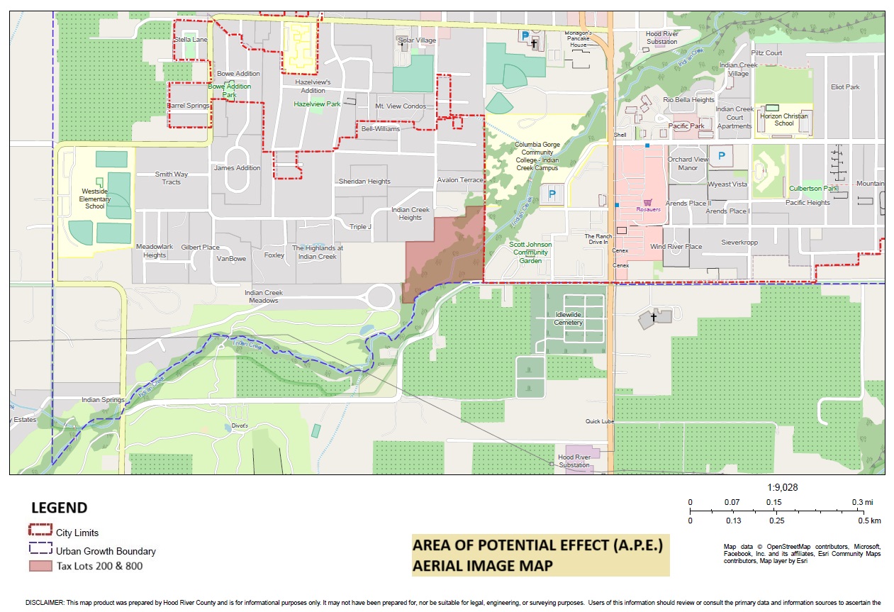
On December 9, the Hood River City Council will make a decision on a request for annexation and zoning change for the property at 3330 Brookside Drive.
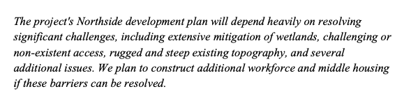
The Developer's proposal claims it will provide much needed affordable housing and give the city the remaining section of the Indian Creek Trail that currently crosses the property.
The question for you. At what cost?
The Problem
The developer wants to Re-Zone two separate areas of a property that is divided by a critical and protected wetland.
The south side would be up-zoned from R-2 (Standard Density Residential) to C-2 (General Commercial Zone) and allow for the construction of 5-Story Buildings.
The north side would be up-zoned from R-1 (Low Density Residential) to R-3 (High Density Residential) and allow for 3-Story Buildings.
Why is that bad?
Unfortunately, the proposal for development is misguided and omits crucial details. It uses terms like "workforce", "middle", and "affordable housing" to obscure the lack of definition in the proposal.
It's based entirely on a practice called Speculative Zoning.
Speculative Zoning is the practice of zoning land for the purpose of reselling it, rather than developing it. The value of the land increases based on the new zoning.
In recent history the practice has been attributed to:
- Inflated land prices
- Housing affordability crisis
- Wealth inequality
- Racial segregation
- Reduced economic growth
In direct conflict with the Developer's own proposal, this practice would likely cause housing to be more expensive — further depleting the stock of affordable housing options in Hood River.
If annexation and rezoning is approved, the Developer has essentially created a Trojan Horse scenario that opens the door to a multitude of ill-defined future uses.
They are attempting to rush through the zoning change without providing an actual plan or providing the required impact assessments for the wetland and surrounding neighborhoods.
From the Developer's Proposal:
How will this impact the wetlands?
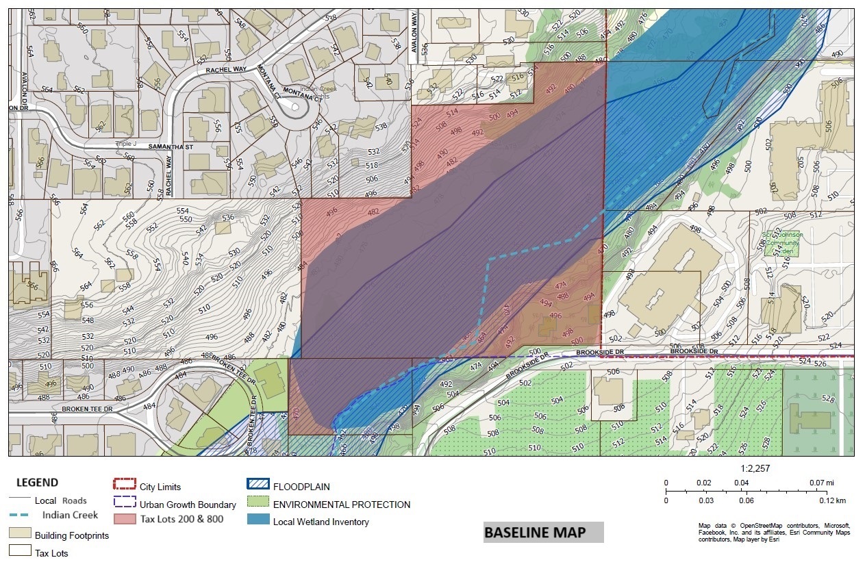
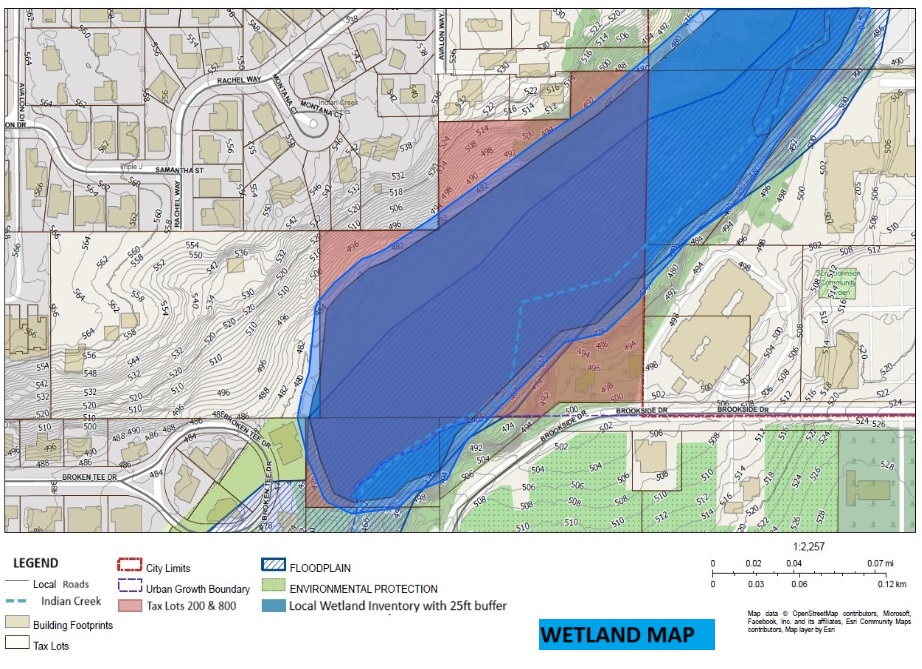
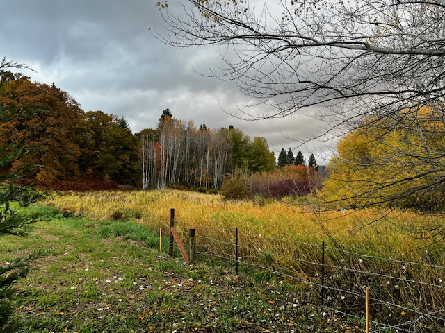
Any development and new construction will irreparably harm a fragile ecosystem. This area is currently listed in Hood River's Inventory of Significant Wetland Determinations and is a tributary of the Hood River.
Any construction needed to meet the new commercial and high density zoning will require monumental amounts of earth moving, extensive and invasive site prep, and astronomically expensive geotechnical engineering.
The displacement of existing soil will disrupt the water table — accelerating hydrological pressure on existing homes in the area and potentially create downstream effects that could impact infrastructure and roadways that we all depend on.
How will this impact the community?
The developer has not provided any type of reputable Impact Statements created by third-party professionals. This means a complete lack of due diligence regarding traffic studies, pedestrian safety, service connectivity (power, water, gas, etc), condition of existing services, soil stability, erosion mitigation, wildlife protection, emergency response access, or road access.
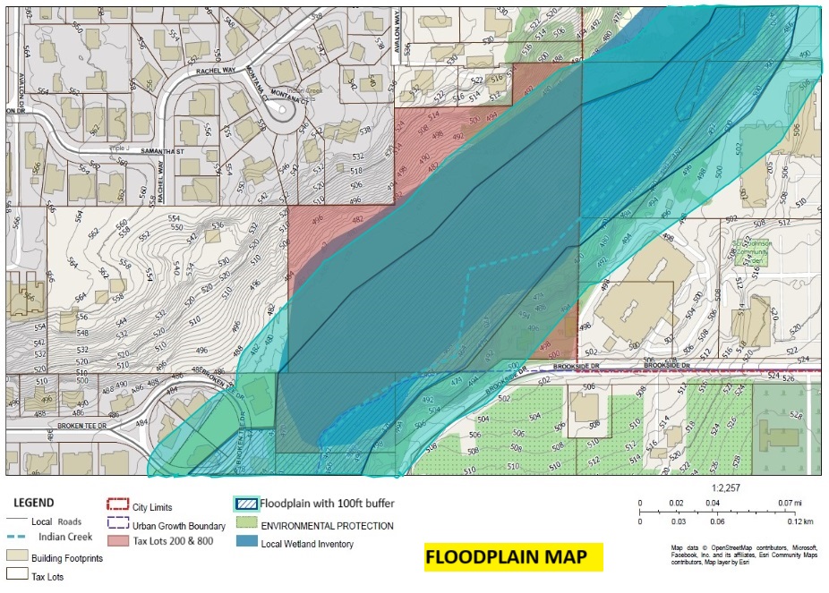
Almost the entirety of the 10.7 acre property is a designated floodplain.
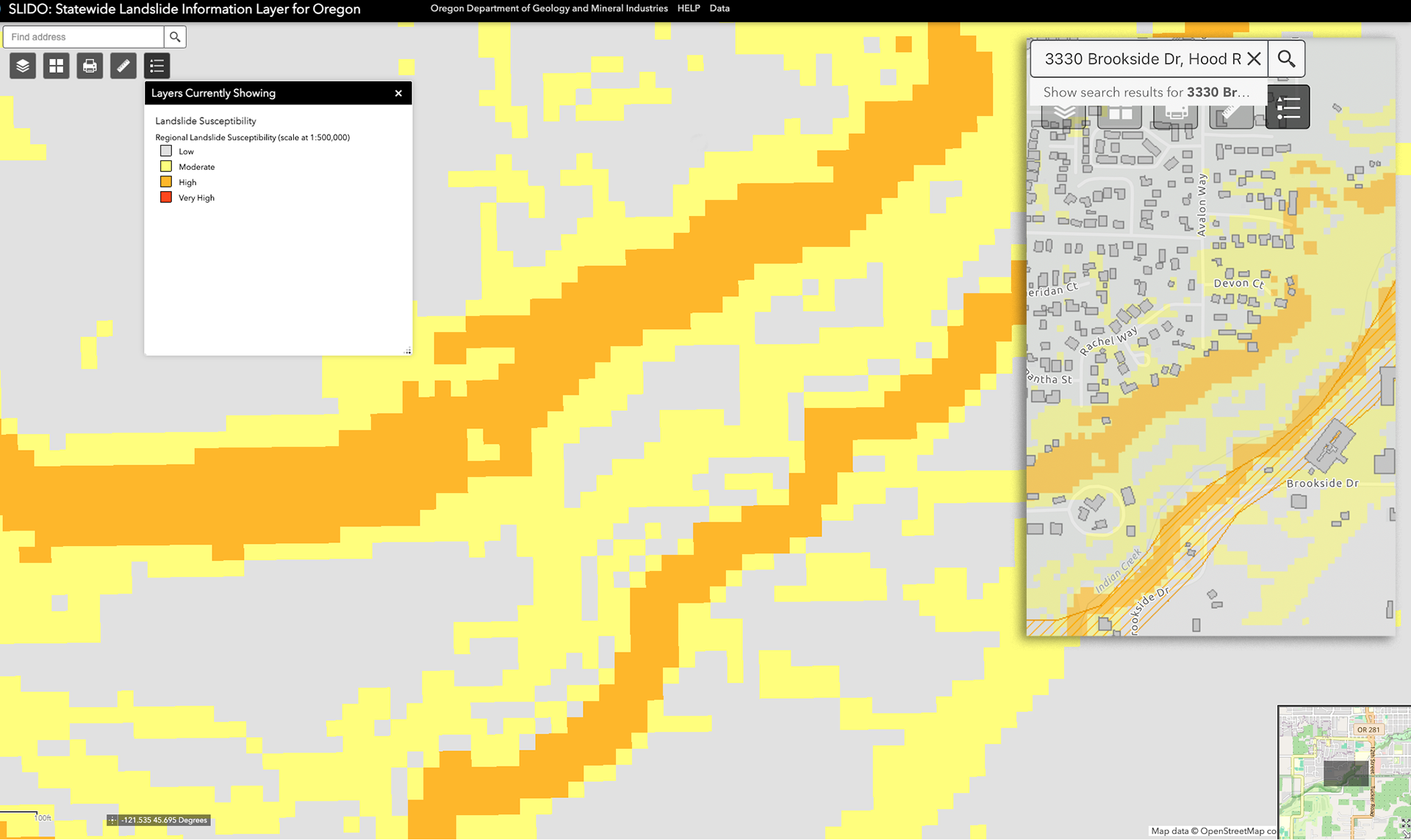
According to FEMA and State of Oregon maps, nearly all of the buildable land on the property is designated as High Risk for landslides. Including 100% of the north bank where the slopes range from 32% to 40%.
As presented, the Developer's Proposal would place our most vulnerable residents, the people this proposal claims to serve, in a dangerous location and subject them to environmental risks while lacking adequate emergency access and services.
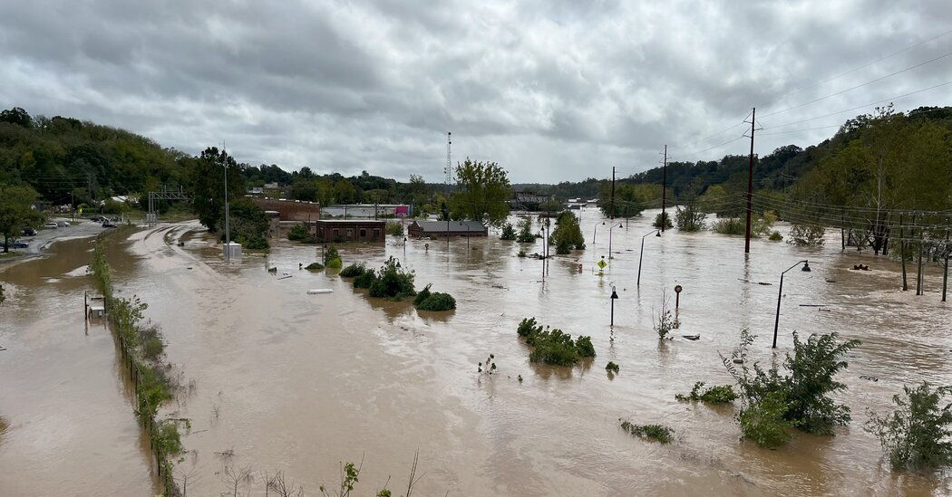
Just look at The Fifth Ward of New Orleans LA, Houston TX, Asheville NC, and Valencia ES for recent ecological disasters that inflicted catastrophic loss of life and property — so much pain, suffering, and loss because of negligent urban planning and runaway development plans.
How does the proposal equate to affordable housing?
It doesn’t.
The entire proposal relies on buzzwords like “work-force housing”, "affordable housing”, “attainable housing”, and “transient hotel housing” to trigger emotions and gain traction while obfuscating the developer’s lack of due diligence.
When you review the facts and consider the realities of the proposed building sites, it becomes clear that this is a thinly veiled attempt to rush a poorly planned development. It does nothing to serve the immediate or future needs of the community. It only inflates the value of the land and lines the pockets of a few people.
This development will not provide affordable housing options because of the high cost of building on such difficult terrain. Even with high-density zoning, the costs associated with infrastructure, environmental mitigation, and road construction make "affordable" housing infeasible.
Take a close look at every affordable housing development that has successfully delivered on that objective. They share a common set of attributes: a flat level building site, access to existing roads and sidewalks, and immediate access to existing services.
This raises the question: Who truly benefits from this annexation and zoning change?
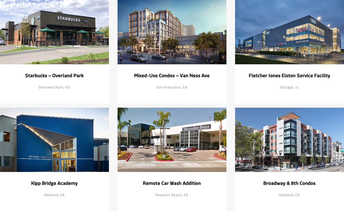
A selection of the Developer's Current Projects:
Will the Indian Creek Trail actually be connected?
The proposal wants you to believe that all this will happen. However, it does not provide a time table, an estimated cost to the taxpayer, or a management plan for how that will happen.
Is that a gamble you’re willing to make?
Ask Yourself
Do you want to see the last, and largest, piece of undeveloped open space in Hood River radically altered forever?
If this proposal is accepted, is the benefit of connecting the Indian Creek Trail worth the environmental impact and degradation that will occur in the future?
Is this actually an "all-or-nothing" moment for the City & Community or is this simply another attempt by developers to cash in on Speculative Zoning?

Where do we go from here?
Read the documents (links below).
Research the developer and their portfolio of projects.
Talk to your friends, neighbors, and community leaders about the issue.
12/9/24 - 12:00PM: Send written comment to the City Recorder: j.gray@cityofhoodriver.gov
12/9/24 - 6:00PM: Attend the Public Hearing at City Hall
Send your comments, concerns, and/or questions to Dustin Nilsen, Planning Director: d.nilsen@cityofhoodriver.gov
Resources
Public Notice sent to surrounding property owners
Proposal from Developer
Wetland Significance Determination
Combined Maps and Overlays
380
The Issue
On December 9, the Hood River City Council will make a decision on a request for annexation and zoning change for the property at 3330 Brookside Drive.
The Developer's proposal claims it will provide much needed affordable housing and give the city the remaining section of the Indian Creek Trail that currently crosses the property.
The question for you. At what cost?
The Problem
The developer wants to Re-Zone two separate areas of a property that is divided by a critical and protected wetland.
The south side would be up-zoned from R-2 (Standard Density Residential) to C-2 (General Commercial Zone) and allow for the construction of 5-Story Buildings.
The north side would be up-zoned from R-1 (Low Density Residential) to R-3 (High Density Residential) and allow for 3-Story Buildings.
Why is that bad?
Unfortunately, the proposal for development is misguided and omits crucial details. It uses terms like "workforce", "middle", and "affordable housing" to obscure the lack of definition in the proposal.
It's based entirely on a practice called Speculative Zoning.
Speculative Zoning is the practice of zoning land for the purpose of reselling it, rather than developing it. The value of the land increases based on the new zoning.
In recent history the practice has been attributed to:
- Inflated land prices
- Housing affordability crisis
- Wealth inequality
- Racial segregation
- Reduced economic growth
In direct conflict with the Developer's own proposal, this practice would likely cause housing to be more expensive — further depleting the stock of affordable housing options in Hood River.
If annexation and rezoning is approved, the Developer has essentially created a Trojan Horse scenario that opens the door to a multitude of ill-defined future uses.
They are attempting to rush through the zoning change without providing an actual plan or providing the required impact assessments for the wetland and surrounding neighborhoods.
From the Developer's Proposal:
How will this impact the wetlands?
Any development and new construction will irreparably harm a fragile ecosystem. This area is currently listed in Hood River's Inventory of Significant Wetland Determinations and is a tributary of the Hood River.
Any construction needed to meet the new commercial and high density zoning will require monumental amounts of earth moving, extensive and invasive site prep, and astronomically expensive geotechnical engineering.
The displacement of existing soil will disrupt the water table — accelerating hydrological pressure on existing homes in the area and potentially create downstream effects that could impact infrastructure and roadways that we all depend on.
How will this impact the community?
The developer has not provided any type of reputable Impact Statements created by third-party professionals. This means a complete lack of due diligence regarding traffic studies, pedestrian safety, service connectivity (power, water, gas, etc), condition of existing services, soil stability, erosion mitigation, wildlife protection, emergency response access, or road access.
Almost the entirety of the 10.7 acre property is a designated floodplain.
According to FEMA and State of Oregon maps, nearly all of the buildable land on the property is designated as High Risk for landslides. Including 100% of the north bank where the slopes range from 32% to 40%.
As presented, the Developer's Proposal would place our most vulnerable residents, the people this proposal claims to serve, in a dangerous location and subject them to environmental risks while lacking adequate emergency access and services.
Just look at The Fifth Ward of New Orleans LA, Houston TX, Asheville NC, and Valencia ES for recent ecological disasters that inflicted catastrophic loss of life and property — so much pain, suffering, and loss because of negligent urban planning and runaway development plans.
How does the proposal equate to affordable housing?
It doesn’t.
The entire proposal relies on buzzwords like “work-force housing”, "affordable housing”, “attainable housing”, and “transient hotel housing” to trigger emotions and gain traction while obfuscating the developer’s lack of due diligence.
When you review the facts and consider the realities of the proposed building sites, it becomes clear that this is a thinly veiled attempt to rush a poorly planned development. It does nothing to serve the immediate or future needs of the community. It only inflates the value of the land and lines the pockets of a few people.
This development will not provide affordable housing options because of the high cost of building on such difficult terrain. Even with high-density zoning, the costs associated with infrastructure, environmental mitigation, and road construction make "affordable" housing infeasible.
Take a close look at every affordable housing development that has successfully delivered on that objective. They share a common set of attributes: a flat level building site, access to existing roads and sidewalks, and immediate access to existing services.
This raises the question: Who truly benefits from this annexation and zoning change?
A selection of the Developer's Current Projects:
Will the Indian Creek Trail actually be connected?
The proposal wants you to believe that all this will happen. However, it does not provide a time table, an estimated cost to the taxpayer, or a management plan for how that will happen.
Is that a gamble you’re willing to make?
Ask Yourself
Do you want to see the last, and largest, piece of undeveloped open space in Hood River radically altered forever?
If this proposal is accepted, is the benefit of connecting the Indian Creek Trail worth the environmental impact and degradation that will occur in the future?
Is this actually an "all-or-nothing" moment for the City & Community or is this simply another attempt by developers to cash in on Speculative Zoning?
Where do we go from here?
Read the documents (links below).
Research the developer and their portfolio of projects.
Talk to your friends, neighbors, and community leaders about the issue.
12/9/24 - 12:00PM: Send written comment to the City Recorder: j.gray@cityofhoodriver.gov
12/9/24 - 6:00PM: Attend the Public Hearing at City Hall
Send your comments, concerns, and/or questions to Dustin Nilsen, Planning Director: d.nilsen@cityofhoodriver.gov
Resources
Public Notice sent to surrounding property owners
Proposal from Developer
Wetland Significance Determination
Combined Maps and Overlays
380
The Decision Makers

Supporter Voices
Petition Updates
Share this petition
Petition created on December 3, 2024