

Create a Southern St George Council in Sydney
The issue
This is a petition for the proposal of a new well defined Southern St George Council directed at The Office of Local Government NSW which is something that is well overdue for residents in Sydney's Southern Suburbs of St George. This will highly benefit residents financially and cater towards growing needs in the local community.
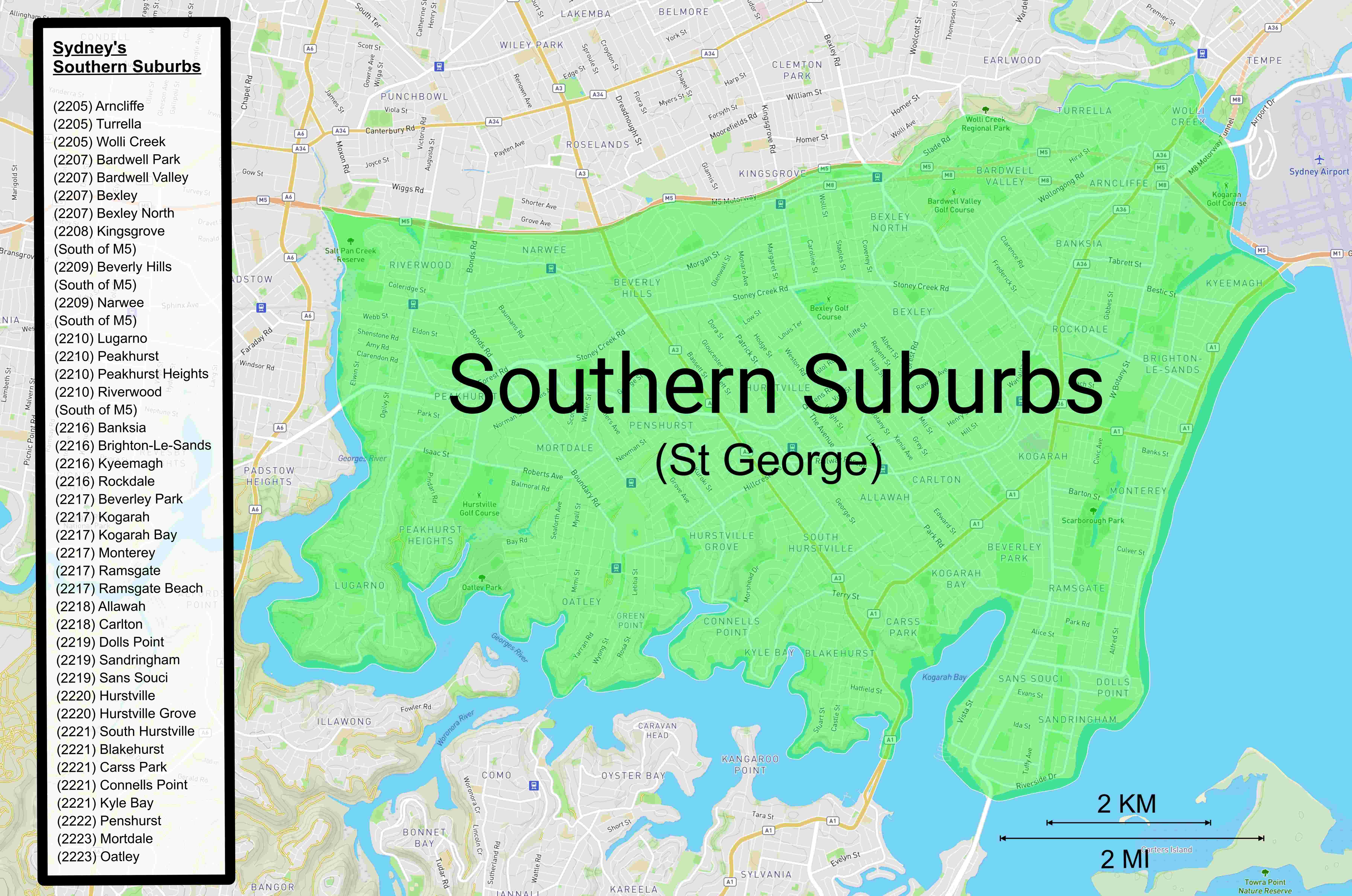
The boundaries of the proposed council will be Salt Pan Creek to the west, The Georges River to the south, Botany Bay to the west and Wolli Creek & The M5 to the north. This would incorporate all of The Georges River Council and the western part of Bayside Council that used to be Rockdale City Council. Postcodes would be 2205, 2207-2210, 2216-2223. Roughly this area would correspond with the electoral districts of ‘Rockdale’, ‘Kogarah’ and ‘Oatley’ collectively. This council would have the population of approximately 280,000.
The proposed suburbs within Sydney's Southern St George Council include:
Bayside Council (Western Side)
(2205) Arncliffe
(2205) Turrella
(2205) Wolli Creek
(2207) Bardwell Park
(2207) Bardwell Valley
(2207) Bexley
(2207) Bexley North
(2216) Banksia
(2216) Brighton-Le-Sands
(2216) Kyeemagh
(2216) Rockdale
(2217) Monterey
(2217) Ramsgate
(2217) Ramsgate Beach
(2219) Dolls Point
(2219) Sandringham
(2219) Sans Souci
Georges River Council
(2208) Kingsgrove (South of M5)
(2209) Beverly Hills (South of M5)
(2209) Narwee (South of M5)
(2210) Lugarno
(2210) Peakhurst
(2210) Peakhurst Heights
(2210) Riverwood (South of M5)
(2217) Beverley Park
(2217) Kogarah
(2217) Kogarah Bay
(2218) Allawah
(2218) Carlton
(2220) Hurstville
(2220) Hurstville Grove
(2221) South Hurstville
(2221) Blakehurst
(2221) Carss Park
(2221) Connells Point
(2221) Kyle Bay
(2222) Penshurst
(2223) Mortdale
(2223) Oatley
This petition may come across as belated considering the NSW liberal government had Sydney amalgamation proposals and mergers back between 2013 and 2017 with many former councils being forcibly amalgamated into some mega councils we have now named after their regions rather than the suburb from which they started while other traditional councils were left untouched due to conflicts of interest and legal action taken.
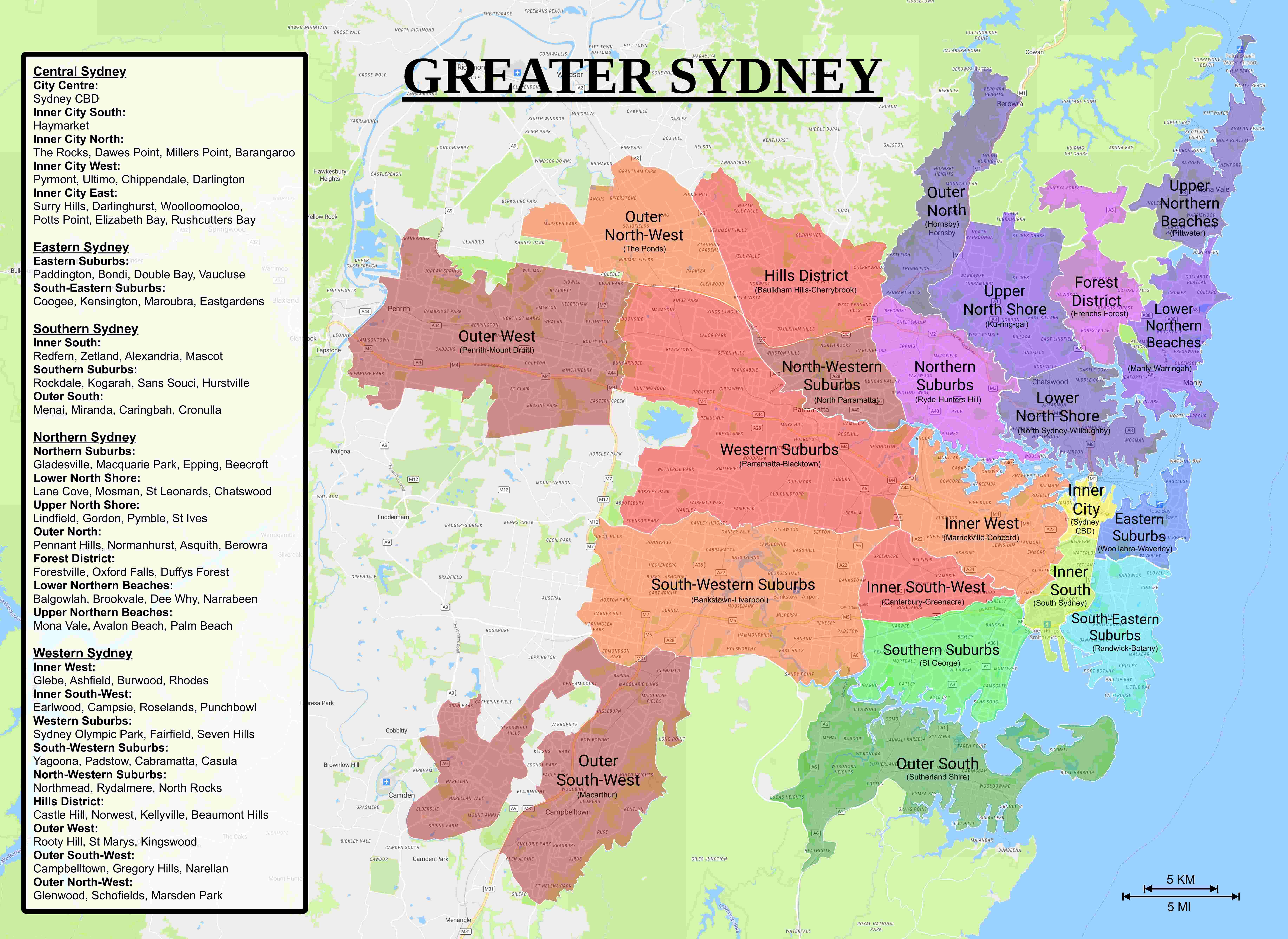
Two amalgamations took place affecting The Southern Suburbs of St George with one being the merge of Hurstville City Council and Kogarah City Council to form the current Georges River Council. The other amalgamation that occurred which was never supported by the community on both sides and is still confounding to most residents today was the forced merger of City of Botany Bay with Rockdale City Council to form the current unnecessarily large Bayside Council. The two councils were separated by Botany Bay and Sydney Airport with both existing in separate areas of Sydney, Rockdale City Council being part of Sydney's Southern Suburbs in The St George Region and City of Botany Bay being within Sydney's Inner Southern Suburbs and Sydney's South-Eastern Suburbs around the airport.
Many residents of Rockdale City Council logically favoured merging with their southern neighbours of Hurstville City Council and Kogarah City Council which meant that it would have created this absolute Southern St George Council. The problem with this plan was City of Botany Bay appearing to be an unplaceable problem with majority of City of Botany Bay residents not wanting to merge with any neighbouring councils and the neighbouring councils of City of Sydney and Randwick City Council also not wanting to merge with them along with the former plans of merging Randwick City Council with Waverley Council and Woollahra Municipal Council that never went ahead. There was another plan to merge City of Botany Bay with the four councils of City of Sydney, Randwick City Council, Waverley Council and Woollahra Municipal Council into a mega inner metropolitan council, however with these plans not going forward it appeared the only thing left to do was to merge City of Botany Bay with Rockdale City Council with the only thing they had in common being their encompassing of Botany Bay.
The region gets its name from The Parish of St George, a Cumberland County cadastral parish used for land title purposes. The parish actually includes everything below The Cooks River however more modern references to The St George Region only refer to everything south of Wolli Creek and The M5 which is considered Sydney’s Southern Suburbs omitting the northern part of the parish which is considered Sydney’s Inner South-West. This northern portion of The Parish of St George was formerly in The City of Canterbury, a council which had a well defined area of being Sydney’s Inner South-West however was also forcibly merged with City of Bankstown to form the current unnecessarily large City of Canterbury-Bankstown.
Some possibilities of What to do with the rest of Bayside Council that was once City of Botany Bay would be to give Mascot, the rest of Rosebery and the portion of Eastlakes that’s west of The M1 to City of Sydney to form a complete Central & South Sydney Council. Give the portion of Bayside Council that’s east of Southern Cross Drive and Mill Stream to Randwick City Council to form a complete South-Eastern Suburbs Council.
This proposal is to get The Office of Local Government NSW to change things for the better in the community, closer to where they should be historically, culturally, geographically, demographically and socio-economically. Sign this petition if you agree.
The issue
This is a petition for the proposal of a new well defined Southern St George Council directed at The Office of Local Government NSW which is something that is well overdue for residents in Sydney's Southern Suburbs of St George. This will highly benefit residents financially and cater towards growing needs in the local community.
The boundaries of the proposed council will be Salt Pan Creek to the west, The Georges River to the south, Botany Bay to the west and Wolli Creek & The M5 to the north. This would incorporate all of The Georges River Council and the western part of Bayside Council that used to be Rockdale City Council. Postcodes would be 2205, 2207-2210, 2216-2223. Roughly this area would correspond with the electoral districts of ‘Rockdale’, ‘Kogarah’ and ‘Oatley’ collectively. This council would have the population of approximately 280,000.
The proposed suburbs within Sydney's Southern St George Council include:
Bayside Council (Western Side)
(2205) Arncliffe
(2205) Turrella
(2205) Wolli Creek
(2207) Bardwell Park
(2207) Bardwell Valley
(2207) Bexley
(2207) Bexley North
(2216) Banksia
(2216) Brighton-Le-Sands
(2216) Kyeemagh
(2216) Rockdale
(2217) Monterey
(2217) Ramsgate
(2217) Ramsgate Beach
(2219) Dolls Point
(2219) Sandringham
(2219) Sans Souci
Georges River Council
(2208) Kingsgrove (South of M5)
(2209) Beverly Hills (South of M5)
(2209) Narwee (South of M5)
(2210) Lugarno
(2210) Peakhurst
(2210) Peakhurst Heights
(2210) Riverwood (South of M5)
(2217) Beverley Park
(2217) Kogarah
(2217) Kogarah Bay
(2218) Allawah
(2218) Carlton
(2220) Hurstville
(2220) Hurstville Grove
(2221) South Hurstville
(2221) Blakehurst
(2221) Carss Park
(2221) Connells Point
(2221) Kyle Bay
(2222) Penshurst
(2223) Mortdale
(2223) Oatley
This petition may come across as belated considering the NSW liberal government had Sydney amalgamation proposals and mergers back between 2013 and 2017 with many former councils being forcibly amalgamated into some mega councils we have now named after their regions rather than the suburb from which they started while other traditional councils were left untouched due to conflicts of interest and legal action taken.
Two amalgamations took place affecting The Southern Suburbs of St George with one being the merge of Hurstville City Council and Kogarah City Council to form the current Georges River Council. The other amalgamation that occurred which was never supported by the community on both sides and is still confounding to most residents today was the forced merger of City of Botany Bay with Rockdale City Council to form the current unnecessarily large Bayside Council. The two councils were separated by Botany Bay and Sydney Airport with both existing in separate areas of Sydney, Rockdale City Council being part of Sydney's Southern Suburbs in The St George Region and City of Botany Bay being within Sydney's Inner Southern Suburbs and Sydney's South-Eastern Suburbs around the airport.
Many residents of Rockdale City Council logically favoured merging with their southern neighbours of Hurstville City Council and Kogarah City Council which meant that it would have created this absolute Southern St George Council. The problem with this plan was City of Botany Bay appearing to be an unplaceable problem with majority of City of Botany Bay residents not wanting to merge with any neighbouring councils and the neighbouring councils of City of Sydney and Randwick City Council also not wanting to merge with them along with the former plans of merging Randwick City Council with Waverley Council and Woollahra Municipal Council that never went ahead. There was another plan to merge City of Botany Bay with the four councils of City of Sydney, Randwick City Council, Waverley Council and Woollahra Municipal Council into a mega inner metropolitan council, however with these plans not going forward it appeared the only thing left to do was to merge City of Botany Bay with Rockdale City Council with the only thing they had in common being their encompassing of Botany Bay.
The region gets its name from The Parish of St George, a Cumberland County cadastral parish used for land title purposes. The parish actually includes everything below The Cooks River however more modern references to The St George Region only refer to everything south of Wolli Creek and The M5 which is considered Sydney’s Southern Suburbs omitting the northern part of the parish which is considered Sydney’s Inner South-West. This northern portion of The Parish of St George was formerly in The City of Canterbury, a council which had a well defined area of being Sydney’s Inner South-West however was also forcibly merged with City of Bankstown to form the current unnecessarily large City of Canterbury-Bankstown.
Some possibilities of What to do with the rest of Bayside Council that was once City of Botany Bay would be to give Mascot, the rest of Rosebery and the portion of Eastlakes that’s west of The M1 to City of Sydney to form a complete Central & South Sydney Council. Give the portion of Bayside Council that’s east of Southern Cross Drive and Mill Stream to Randwick City Council to form a complete South-Eastern Suburbs Council.
This proposal is to get The Office of Local Government NSW to change things for the better in the community, closer to where they should be historically, culturally, geographically, demographically and socio-economically. Sign this petition if you agree.
The Decision Makers
Petition Updates
Share this petition
Petition created on 27 July 2023