WIRRAL COUNCIL ASKED BY PEAK CLUSTER TO ALLOW SURVEYS ON COUNCIL LAND - WE NEED YOUR HELP PLEASE

PEOPLE OF WIRRAL, WE NEED YOUR HELP – WE NEED YOU TO EMAIL WIRRAL COUNCILLORS ON THE POLICY AND RESOURCE COMMITTEE
You may have seen reports that Peak Cluster have asked permission from Wirral Council to enter the Council’s land to undertake surveys.
https://www.wirralglobe.co.uk/news/26516553.peak-cluster-request-considered-wirral-council/
Normally, council officers would make the decision as to whether to allow access to land but, because of the “significant public interest”, the decision will be taken by Councillors in the “Policy and Resources Committee”
A Committee meeting will take place next Wednesday 9th September 2026 at 6pm.
We hope that the Councillors, who all unanimously opposed Peak Cluster at the Extraordinary Meeting on March 9th and who joined the protest at New Brighton will stick to their word and continue to do everything they can to oppose Peak Cluster.
Peak Cluster want to undertake survey works on the following Council owned land:
Land lying to the South of Saughall Massie Road, Greasby.
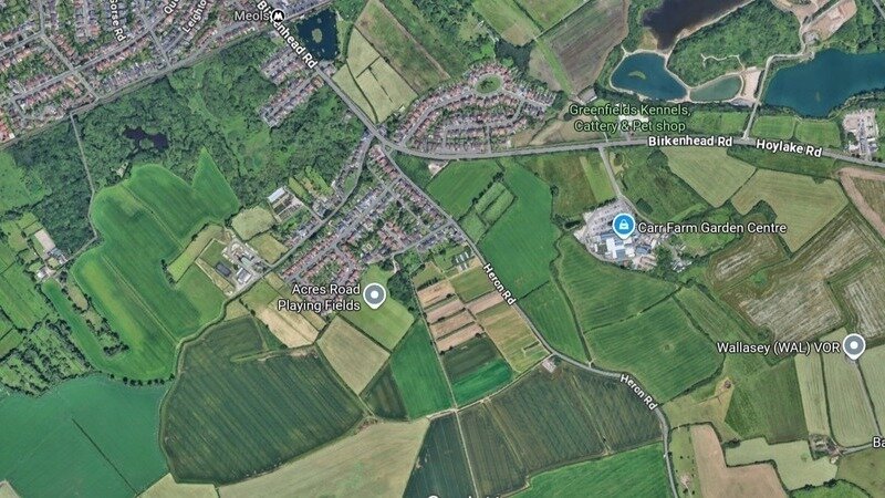
Land on the East of Heron Rd, Meols.
Land fronting Heron Rd and Saughall Massie Rd, Saughall Massie.
Land known as the Buldower, lying to the North of Birkenhead Rd, Meols.
Land lying foreshore at Wallasey
Land at Acres Rd, Meols and land on the South side of Acres Rd
These fields are one of the likely places for the proposed “Coastal AGI”. The AGI is large industrial complex, the size of 8 football pitches. It will compress CO2 not just from Peak District cement factories but potentially CO2 imported, via Tranmere, from carbon heavy industries all over Europe.
The surveys are for the following:
“Non Intrusive Surveys: Noise and Vibration, Cultural and Heritage, Biodiversity (habitat & plants, newts & amphibians, birds, bats, otter & water vole, badger, land, soils and geotechnical, landscape and & visual, water, traffic & transport and arboriculture
Note: These Surveys can take place out of hours and over specific areas in the year
Intrusive Surveys: Boreholes, trial pits, instillation and monitoring of piezometers, soakaway tests, utility identification, resistivity surveys and cultural heritage intrusive surveys.”
The purpose of the biodiversity surveys is to facilitate compliance with environmental impact assessment and habitats regulations assessment requirements.
We strongly suspect that Peak Cluster may be keen to complete these surveys as soon as possible before the Hoylake Wetland and Flood Risk Management Scheme (currently under construction on nearby fields) starts to bring increased biodiversity to the area including numerous endangered bird species.
The Council is under no obligation, at this stage, to agree to providing access to its landholdings for this purpose.
More information can be found in the Policy and Resources Committee Report:
PLEASE EMAIL YOU LOCAL COUNCILLOR AND THE COUNCILLORS ON THE POLICY AND RESOURCES COMMITTEE – Let them know whether you think they should reject Peak Clusters request for access to Council Owned land. Let them know what you think about the surveys being undertaken before the wetlands have had chance to establish. Just a few sentences will do – it takes just a few minutes:
You can copy and paste the Committee members emails from the list below. Your local Councillor’s contact details can be found on the Council website :
https://democracy.wirral.gov.uk/mgMemberIndex.aspx?FN=WARD&VW=TABLE&PIC=1
Thank you for your support.
paulabasnett@wirral.gov.uk
juliemcmanus@wirral.gov.uk
ruthmolyneux@wirral.gov.uk
simonmountney@wirral.gov.uk
christophercarubia@wirral.gov.uk
kathyhodson@wirral.gov.uk
stephenbennett@wirral.gov.uk
angeladavies@wirral.gov.uk
stevefoulkes@wirral.gov.uk
tonymurphy@wirral.gov.uk, suepowellwilde@wirral.gov.uk
markskillicorn@wirral.gov.uk
jobird@wirral.gov.uk
gailjenkinson@wirral.gov.uk
edlamb@wirral.gov.uk
maxbooth@wirral.gov.uk
jeffgreen@wirral.gov.uk
jennyjohnson2@wirral.gov.uk
philgilchrist@wirral.gov.uk