Guess what?! We have smashed it!
Our petition has been signed by over 1230 people and it’s still climbing! Thank you!
Just a little gossip to add to the pot, admittedly I do not know how factual this information is.. who supposedly said it or who sourced the information, so do not quote me on it!
But it goes like this, a friend of a friend who was talking to a friend who was told by a friend that somebody was possibly thinking of having the the pond removed from the Memorial Park, there was apparently also a comment about the land being landfilled and the natural brook drainage system through Leafy Lane removed!!
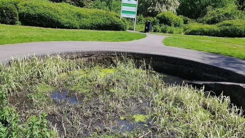
This pond was revamped in 2009 using lottery grants and capital funding.. while it needs a little tidy up, it is a complete waste of Amber Valley Council tax payers money to drastically change or remove our community pond. While it doesn’t look loved at the moment, even more so when ground water levels are low, instead of ruining all natural habitats such as a home for newts and frogs, all our pond needs is a little love and tidy up.. it’s not rocket science!
True or not statements like removing ponds and natural drainage systems are a very big concern!
Drainage and the aquifer, again:
As stated in a Amber Valley Parks document, this pond has frogs and newts when the water levels are high! It is also a drainage system for the aquifer.
Aquifer again .. what’s that mean, you might be saying.. well when groundwater levels are high, the pond acts as a drainage system linking to the brook that runs through the Leafy Lane Woodland.
BGS shows a map with Leafy Lane and some neighbouring areas being made up of “Till, Mid Pleistocene - Diamicton. Sedimentary superficial deposit formed between 860 and 116 thousand years ago during the Quaternary period.”
Basically, it sits on an old glacier and has hard land that doesn’t drain well.
It is the main reason for there being a pond, a drainage brook and as a guess a splash pad!
I think it is safe to say that we can thank our biodiverse trees, natural brook and our pond drainage for helping prevent neighbouring houses from flooding! With all this water helping flora survive, no wonder our birds and other wildlife fauna are thriving here!
So.. if this information is to be believed, is this really a good idea to remove a natural drainage system?
Another little fact:
Did you know that in 1885, Sooky Hollow was known as Old Hollows?
An Old Map was recently discovered regarding a subsidence dispute in 1903 and it shows coal workings close to The Rectory (Leafy Lane Depot).
Along with various fault lines, The map showed Sookey Hollow being Old Hollows in 1885.
You can view it here:
Heanor Bygones Rectory Coal Map
Since the map coal workings have been substantial around this land.
With 9 Coal Seams and an old glacier.. I wonder what risks this means if the land is disturbed or natural drainage changed? Water inrush to the mines… ground heave… subsidence... flooding… mine gas…
All for the sake of 50 houses!! Unbelievable!
I wouldn’t like to be one of the 35+ residents living on the boundary of this land when or if development happens... Or even at the edge of the aquifer.. Oh wait, I am one!
Again, thank you to everyone that is helping the campaign, it is very much appreciated.