
Putnam County Tenn. Commission: Please Enact A New Major Thoroughfare Plan For 2026-2046!
The Issue
Putnam County, Tennessee needs a new Major Thoroughfare Plan. The old one was intended to expire in 2024, was only legislatively binding for subdivision developers and seemingly relied on assumptions that the TDOT and Cookeville road department would build far more arterial roads bypassing the city core than they actually did. It also left some state aid roads and important truck routes off of the county's designated collector roads and failed to effectively sort the collector roads based on state aid eligibility and whether the road is truck-friendly or not.
I'm suggesting splitting the original Major Collector Roads and Minor Collector Roads into four separate major categories, too, with two unique categories. You don't have to read the finer details past the six classifications if it's too much, but please sign and share my petition if you agree!
Minor Collectors should be residential roads that are not on the state aid system nor key truck routes but have enough traffic to register on Google Maps traffic data, the main roads into subdivisions with at least 50 houses, through roads that fail other criteria but have an uninhabited segment or are part of TDOT’s functional classification but neither truck-friendly nor state aid roads, and the goal should be to widen them to a consistent 18 feet and to require subdivision developers to either widen them to thirty feet (three ten-foot lanes) or two ten-foot lanes with a ten-foot median.
Major Collectors should be residential roads that are on the state aid system. The goal should be to widen them to meet the TDOT's standards for rural local or collector roads (depending on how the official TDOT maps classify them), potentially even suburban local or collector roads if there's sufficient right-of-way for the sidewalks (and turning and bike lanes for collector roads) that that would entail. Developers should be required to reserve sufficient right-of-way to meet the TDOT's suburban collector road standards, starting out with a three-lane road with extra right-of-way for the standard four-lane divided highway in case traffic volumes increase.
Local Arterials (NOT to be confused with the Arterial Roads shown in the old Major Thoroughfare Plan, which are state routes) should be mixed-use roads that are on the state aid system, with a turning radius never below sixty-five feet to ensure a standard fifty-three foot tractor trailer can safely make every twist and turn. The goal should be to widen them to meet the TDOT's standards for rural local or collector roads (depending on how the official TDOT maps classify them), potentially even suburban local or collector roads if there's sufficient right-of-way for the sidewalks (and turning and bike lanes for collector roads) that that would entail. Developers should be required to reserve sufficient right-of-way to meet the TDOT's suburban collector road standards, starting out with a three-lane road with extra right-of-way for the standard four-lane divided highway in case traffic volumes increase.
Truck Routes should be mixed-use roads that are not on the state aid system, with a turning radius never below sixty-five feet to ensure a standard fifty-three foot tractor trailer can safely make every twist and turn. The goal should be to widen them to a consistent 20 feet and to require industrial or subdivision developers to widen them to at least 32 feet if there's at least 36 feet of right-of-way available in areas they're not developing, or to 26 feet if there's only 30 feet of right-of-way, and reserve sufficient right-of-way in developed areas for possible expansion to the aforementioned four-lane divided highways. The suggested Truck Routes can be further split into the Buffalo Valley Truck Route, Cookeville Boatdock Bypass Route, Cookeville to Gainesboro Truck Route, Burgess School Bypass Route, North Cookeville Bypass Route, Fisk Industrial Truck Route, Glade Creek Truck Route, Monterey Industrial Truck Route and Dripping Springs Turn Truck Route.
The part of Baxter Road north of Window Cliff Road should be classified as a Local Arterial Bike Route because it's part of an official bike route between Baxter and Sparta, with state aid being sought to widen it to a consistent 28 feet to meet rural state collector standards for roads with a bike route. Otherwise, this portion of Baxter Road should be treated the same as any other Local Arterials.
Window Cliff Road should be classified as a Local Bike Route because it's part of an official bike route between Baxter and Sparta, with my recommendation being to study the possibility of adding 4-foot bike lanes if traffic warrants it. Otherwise, treat as essentially any other minor collector road.
Apart from the Bike Route along Baxter Road and Window Cliff Road, here is every road in the other four categories and the recommended course of action. You can stop reading now if it's too long, but please sign and share this petition if you agree so far!
Local Arterials...
- Saint Mary's Road: post eastbound Speed Limit 35 sign and westbound Speed Limit 55 sign at Smith County line to clarify speed limit change - if Smith County approves and/or the TDOT approves a state aid project for clearer signage
- part of Ensor Hollow Road (south of Webster Road): post signs warning to Watch For Trucks Crossing Centerline at sharp curves
- part of Ensor Hollow Road (north of Webster Road): widen to a consistent 18 feet (seek state aid funding if necessary) and post signs warning to Watch For Trucks Crossing Centerline at sharp curves
- Spring Fork Road: no action recommended
- part of Hopewell Road (west of Indian Creek Road): post To Interstate 40 sign directing traffic towards State Route 96 southbound and Speed Limit 40 sign just west of Indian Creek Road
- Old Baxter Road: Widen to 22 feet by paving over existing gravel shoulders and laying new gravel shoulders beyond the extended pavement. Post Do Not Stop On Tracks signs on side roads with closely spaced railroad crossings (e.g. Monroe Henley Ridge Road) and Do Not Block Intersection signs at intersections with those same side roads. Seek state aid to install level crossing signals at Old Baxter Road crossing. Make #1 priority for snow removal to keep interstate detour route safe/open just in case (with the Stanton Road/Indian Creek Road/Hopewell Road truck route as the #2 priority if a separate westbound detour is established), and if that's not enough, ask the TDOT to designate Old Baxter Road and First Avenue North as part of State Route 141 or as a separate State Route 479 (with Stanton Road and the western parts of Indian Creek Road and Hopewell Road as a potential State Route 480 or realigned State Route 24) to ensure adequate winter maintenance.
- part of Cookeville Boatdock Road (southwest of Thomas Twin Oak Road): Post northbound stop sign at Austin Bottom Road and southbound stop sign at Baxter Road to improve safety and efficiency of Y-intersections. Post Truck Advisory Signs warning of insufficient turn radius to turn around on Austin Lake Road; if the owners of the Cookeville Boatdock won't let local businesses with driveways pointed the wrong way turn around, classify this as Major Collector south of Thomas Twin Oak Road.
- part of Baxter Road (south of Thomas Twin Oak Road): post Truck Advisory Signs warning of insufficient turn radius to turn around on Austin Lake Road; if the owners of the Cookeville Boatdock won't let local businesses with driveways pointed the wrong way turn around, classify this as Major Collector south of Thomas Twin Oak Road
- Ward Mill Road: Ask the TDOT about building the State Industrial Access Road to Anatolia Granite on top of existing Ward Mill Road and Nashville Highway to reduce right-of-way costs and ongoing property disputes and adding sidewalks and turning lane to bring up to suburban collector standards. Failing that, repeal truck ban if it's in violation of federal law requiring "reasonable access" within a mile of national highways (if not and the SIA isn't built here, reclassify this as Major Collector), widen to consistent 22 feet (seeking state aid if necessary) and lay new gravel shoulders beyond the extended pavement.
- part of Baxter Road (between Thomas Twin Oak Road and Window Cliff Road): post Truck Advisory Signs warning of insufficient turn radius to turn around on Austin Lake Road and warning that Thomas Twin Oak Road is the last safe place to turn to divert
- part of Old Gainesboro Road (near Jackson County line): no action recommended
- part of Cookeville Boatdock Road (northeast of Thomas Twin Oak Road): Widen to 24 feet (seek state aid if necessary), paving over existing gravel shoulders and laying new gravel shoulders beyond the extended pavement. Post Truck Advisory Signs warning of insufficient turn radius to turn around on Austin Lake Road and warning that Thomas Twin Oak Road is the last safe place to turn to divert.
- Cumby Road: no action recommended
- part of Ditty Road (northwest of State Route 135): Widen to 22 feet (seek state aid if necessary), paving over existing gravel shoulders and laying new gravel shoulders beyond the extended pavement - and move mailboxes to accommodate the wider road. Re-paint passing zone in high-visibility spot near Neely Road once road is widened enough to safely accommodate it again. Make the #4 priority for snow removal to ensure traffic between Baxter (and Gainesboro) and Sparta/Chattanooga is largely uninterrupted.
- part of Pippin Road (west of County Farm Road): Put up northbound stop signs at Plunk Whitson Road and southern end of County Farm Road concurrency to make Y-intersections safer and more efficient. Also, widen to consistent 20 feet (seek state aid if necessary) most of the way and 24 feet along County Farm Road concurrency, paving over existing gravel shoulders and laying new gravel shoulders beyond the extended pavement; road has insufficient right-of-way to meet state suburban collector road standards but can still be easily brought up to rural collector standards.
- part of Ditty Road (between S.R. 135 and Solon Jared Road): Ask developer to widen road to 32 feet or to two 11-foot lanes with 10-foot median and reserve 80 feet of right-of-way to support a five-lane road or four-lane divided highway (already asked to by Road Supervisor Randy Jones). Make the #4 priority for snow removal to ensure traffic between Baxter (and Gainesboro) and Sparta/Chattanooga is largely uninterrupted.
- part of Buffalo Valley Road (between Baxter and Cookeville): widen to 22 feet (seek state aid if needed), paving over existing gravel shoulders and laying new gravel shoulders beyond the extended pavement
- Plunk Whitson Road: Ask the TDOT for a traffic light or roundabout at the U.S. Route 70N intersection to improve safety. If the TDOT agrees and also adds sidewalks on Hawkins Crawford Road from the railroad crossing to U.S. Route 70N, ask for state aid to build sidewalks along Plunk Whitson Road to connect subdivisions there to the rail trail and meet state standards for suburban local roads.
- County Farm Road: Widen to consistent 22 feet south of Pippin Road concurrency and 24 feet along and north of Pippin Road concurrency (seek state aid if needed), paving over the existing gravel shoulders and laying new gravel shoulders beyond the extended pavement. Add northbound stop sign on Pippin Road at southern Y-intersection to make it safer and more efficient.
- Shipley Road: Post stop signs to create all-way stop at North Allen Road's oddly-shaped intersection. Also, build sidewalks (seek state aid if necessary) to meet state suburban local road standards and give subdivision streets pedestrian access to commerce in Cookeville and TTU.
- part of Ditty Road (southeast of Solon Jared Road): Widen to 22 feet (seek state aid if necessary), paving over existing gravel shoulders and laying new gravel shoulders beyond the extended pavement. Make the #4 priority for snow removal to ensure traffic between Baxter (and Gainesboro) and Sparta/Chattanooga is largely uninterrupted.
- South Lovelady Road: no action recommended
- West Whitehall Road: no action recommended
- Bartlett Road: no action recommended
- Howard Draper Road: post signs warning to Watch For Trucks Crossing Centerline at sharp curve
- Bob Lynn Road: no action recommended
- Free Hill Road: post Speed Limit 55 signs to clarify that the 30 mph speed limit in the Cookeville city limits doesn't apply out in the county
- East Whitehall Road: no action recommended
- Hutcheson Road: ask the TDOT for a roundabout at the intersection with S.R. 136 and Fisk Road to simplify it and make it more efficient and safer (already publicly supported by both 11th district County Commissioners Kathy Dunn and Darren Wilson, and already planned by the TDOT to be implemented - thank you!)
- Quinland Lake Road: no action recommended
- Old Bridge Road: no action recommended
- Paran Road: Widen to 22 feet (ask the TDOT for state aid if needed), paving over the existing gravel shoulders and laying new gravel shoulders beyond the extended pavement. Post eastbound Speed Limit 55 sign at Overton County line to clarify the speed limit change at the county line if Overton County approves and/or the TDOT agrees to a state aid project.
- Stone Seminary Road: no action recommended
- Seven Springs Road: post signs warning to Watch For Trucks Crossing Centerline at sharp curves
- Cherry Creek Road: Post Truck Advisory signs advising southbound trucks to turn right onto Walter Stone Road then left onto Walnut Grove Road to avoid S.R. 84's truck ban. Also, widen to 22 feet (ask the TDOT for state aid if needed), paving over the existing gravel shoulders and laying new gravel shoulders beyond the extended pavement.
- Phifer Mountain Road: widen to a consistent 20 feet and study possibility of converting Baker Mountain Road Y-intersection into a roundabout to simplify it (seek state aid from the TDOT if needed)
- part of Officers Chapel Road (east of State Route 111): post Speed Limit 55 signs to clarify that the 30 mph speed limit in Algood doesn’t apply outside of the town limits
- Buck Mountain Road: Widen to a consistent 24 feet (seek state aid if needed), paving over the existing gravel shoulders and laying new gravel shoulders beyond the extended pavement. Also, have the eastbound truck climbing lane terminate in a right turn lane onto White's Point Drive.
- part of Old Highway 42 (between Officers Chapel Road and Spring Creek Road): no action recommended
- part of Pleasant Ridge Road (west of Sheep Bluff Road): widen to consistent 20 feet (seek state aid from TDOT if needed), paving over the existing gravel shoulders and laying new gravel shoulders beyond the extended pavement
- part of Spring Creek Road (east of Old Highway 42): no action recommended
- Brotherton Mountain Road: Post Do Not Block Intersection and Do Not Stop on Tracks signs at intersections with side roads. Also, ask the TDOT for state aid to add a level crossing signal at the railroad crossing. Make the #3 priority for snow removal along with Woodcliff Road to ensure traffic between Algood and Monterey (and Knoxville) is largely uninterrupted. Last but not least, maintain the passing zone to ensure traffic between Algood and Monterey flows smoothly.
- Sheep Bluff Road: no action recommended
- part of Sand Springs Church Road (northeast of Rocky Point Road): no action recommended
- part of Sand Springs Road (southwest of Rocky Point Road): widen to a consistent 18 feet (ask for state aid if needed)
- Thorn Gap Road: no action recommended
- Stamps Shady Grove Road: post Watch For Trucks Crossing Centerline signs at sharp curves
- Dripping Springs Road: Widen to a consistent 18 feet (seek state aid if needed), paving over the existing gravel shoulders and spreading new gravel shoulders beyond the extended pavement. Also, replace southbound Speed Limit 35 sign at Cumberland County line with Speed Limit 55 sign to clarify the speed limit change across county lines if Cumberland County approves and/or the TDOT agrees to a state aid project.
- Jim Garrett Road: put up southbound Speed Limit 35 sign and northbound Speed Limit 55 sign at Cumberland County line to clarify that Cumberland County's posted 35 mph speed limit doesn't extend into Putnam County, if Cumberland County approves and/or the TDOT agrees to a state aid project
- Muddy Pond Road: put up southbound Speed Limit 45 sign and northbound Speed Limit 55 sign at Overton County line to clarify that Putnam County's posted 45 mph speed limit doesn't extend into Overton County, if Overton County approves and/or the TDOT agrees to a state aid project
- Elmore Road: no action recommended
Major Collectors...
- Webster Road: post No Thru Trucks sign due to insufficient turning radius at Ensor Hollow Road
- Rock Springs Road: Post No Thru Trucks signs. Study putting up speed cameras (seeking state aid if necessary) to enforce 25 mph speed limit consistently, given high non-compliance rate (especially if it's not raised on Stanton Road south of Leftwich Ridge Road or that increase doesn't significantly decrease Rock Springs Road's traffic volume). Only at S curves to comply with state law though.
- part of Buffalo Valley Road (between State Route 96 and S.R. 141): Post No Thru Trucks signs due to sharp curve near Buffalo Valley post office. Post Do Not Stop On Tracks signs on side roads (except Wallace Hollow Road and Doctor Smith Road). If Wallace Hollow Road is a public road, post stop or yield sign on it. Seek state aid to repave rough railroad crossing and install level crossing signals. Study making Doctor Smith Road one-way westbound to promote smoother, safer traffic flow.
- Clemons Ridge Road: post Speed Limit 55 signs to clarify the limits of 25 mph speed limit signs in connected subdivision
- Silver View Lane: widen loop at end to 18 feet (seek state aid if necessary) with two-way yield giving oncoming traffic the right-of-way or make loop at end one-way counterclockwise
- part of Hopewell Road (between Indian Creek Road and Rough Ridge Road): post eastbound No Thru Trucks sign just east of Indian Creek Road and westbound stop sign at Indian Creek Road intersection
- part of Hopewell Road (east of Rough Ridge Road): widen to 20 feet by paving over existing gravel shoulders and laying new gravel shoulders beyond the extended pavement (seek state aid if necessary)
- Austin Bottom Road: Put up warning sign that Austin Lake Road has too tight of a turn radius for trucks to turn around and eastbound stop sign at Goff Ridge Road to improve safety of Y-intersection. Put up Speed Limit 55 or Speed Limit 25 sign at DeKalb County line if DeKalb County approves and/or the TDOT agrees to a state aid project for signage, depending on whether the 25 mph speed limit west of Austin Lake Road is binding on the entire DeKalb County portion or just that segment.
- Academy Road: add all-way stop at Baxter Road to improve safety at low-visibility intersection (Commissioner Danny Holmes said he would ask outgoing Road Supervisor Randy Jones to do so on my behalf - thank you if so! - but as of August 4, 2026, I still saw no new stop signs nor plans to add them)
- Hawkins Crawford Road: Widen to 24 feet (seek state aid if needed), paving over existing gravel shoulders and laying new gravel shoulders beyond the extended pavement. Ask the TDOT for state aid to widen the railroad crossing to 24 feet and add a level crossing signal and sidewalks across and north of the railroad to meet state suburban local road standards and give Big Orange Drive and Plunk Whitson Road a pedestrian connection to the future rail trail. Also ask the TDOT to add traffic lights or a roundabout at the U.S. Route 70N intersection to improve safety.
- Cowan Road: no action recommended
- part of Bennett Road (north of Cowan Road): no action recommended
- Burgess School Road: study converting Y-intersection with Bunker Hill Road to roundabout to simplify it and make it safer and more efficient (ask the TDOT for state aid if needed), banning through trucks if it's built due to the insufficient turn radius a roundabout within existing right-of-way would have
- part of Bunker Hill Road (between South Lovelady Road and Burgess School Road): Study converting Y-intersection with Burgess School Road to roundabout to simplify it and make it safer and more efficient (ask the TDOT for state aid if needed), banning through trucks if it's built due to the insufficient turn radius a roundabout within existing right-of-way would have. Also post Speed Limit 55 signs to clarify that the 30 mph speed limit in Cookeville and 45 mph speed limit in White County don't apply in unincorporated Putnam County.
- West Thomas Allen Road: widen to consistent 20 feet (seek state aid if needed), paving over existing gravel shoulders and laying new gravel shoulders beyond the extended pavement
- part of Fairview Road (north of Whitehall Road): widen to consistent 22 feet (seek state aid if needed), paving over existing gravel shoulders and laying new gravel shoulders beyond the extended pavement, but be sure to maintain existing passing zone
- East Thomas Allen Road: Widen to consistent 20 feet (seek state aid if needed), paving over existing gravel shoulders and laying new gravel shoulders beyond the extended pavement. Also study adding all-way stop at X-intersection with Waterloo Road to improve safety.
- Brown's Mill Road: no action recommended
- part of Poplar Grove Road (southwest of Rocky Point Road): if right-of-way is sufficient on the state aid segment of Poplar Grove Road, build sidewalks (seek state aid if necessary) to meet state suburban local road standards and give subdivision streets pedestrian access to commerce in Cookeville
- Canada Flatt Road: Post stop sign at Poplar Grove Road to give Falling Water Road the right-of-way, ensuring the Y-intersection is safe and efficient. Also, widen to a consistent 18 feet (seek state aid if necessary).
- Rocky Point Road: if right-of-way is sufficient on the state aid segment of Poplar Grove Road for a westward extension of sidewalks, build sidewalks on urban part of Rocky Point Road (seek state aid if necessary) to meet state suburban local road standards and give Shelby Drive and Hyder Mountain Road pedestrian access to commerce in Cookeville and Poplar Grove Baptist Church
- Shady Lane Road: post No Thru Trucks sign to prevent truckers from accidentally running into Rocky Point Road's through truck ban
- Falling Water Road: give right-of-way at Poplar Grove Road/Canada Flatt Road by adding stop sign on Canada Flatt Road
- Mill Creek Road: post eastbound No Thru Trucks sign at U.S. Route 70N to prevent trucks from running into S.R. 84's truck ban
- Woodcliff Road: Post Do Not Block Intersection and Do Not Stop on Tracks signs at intersections with side roads. Also, ask the TDOT for state aid to add level crossing signals at the railroad crossings. Post eastbound No Thru Trucks sign at Brotherton Mountain Road/Stamps Shady Grove Road intersection to prevent trucks from running into Monterey's truck ban. Make the #3 priority for snow removal along with Brotherton Mountain Road to ensure traffic between Algood and Monterey (and Knoxville) is largely uninterrupted (except truck traffic until Stamps Shady Grove Road is cleared). Last but not least, widen to a consistent twenty feet (seek state aid if needed) by paving over the existing gravel shoulders and spreading new gravel shoulders beyond the extended pavement.
- Rock Springs Church Road: Post No Thru Trucks signs due to sharp curves with less than a 55-foot turn radius on Tyler Point Road across Overton County line. Also, widen to a consistent 18 feet (seek state aid from the TDOT if needed).
- Omaha Gap Road: widen to a consistent 18 feet (ask the TDOT for state aid if needed)
Minor Collectors...
- Medley Hill Road: Widen to a consistent 18 feet and pave the entire road with chipseal (due to flooding making asphalt concrete too expensive to be worthwhile), but still paint centerline and fog lines on road once gravel has had time to settle into chipseal and simply sweep off any loose gravel first to prevent paint from coming off. Block residents from lowering the speed limit on unpopulated portion of road northeast of Autrey Road below 35 mph to prevent a repeat situation of an unwarranted too-low-for-cruise-control speed limit on the unpopulated portion of a road similar to what happened on the uninhabited segment of Stanton Road south of Leftwich Ridge Road. Last but not least, add stop sign on Autrey Road and two stop signs on Carr Ridge Road due to low visibility.
- part of Martin Creek Road (west of Flatt Hollow Road): Widen to a consistent 18 feet, matching the three box culverts and portion of the road in Bloomington Springs. Post stop signs at Puncheoncamp Road and warning signs at the new all-way stop for turning traffic to yield to oncoming traffic from Jackson County, given the twelve-foot right-of-way on Puncheoncamp Road preventing widening it to two lanes nor passing on adjacent soil.
- Tightfit Road: Widen to a consistent 18 feet. Block residents from lowering the speed limit on unpopulated portion of road northwest of Tightfit Lane below 35 mph to prevent a repeat situation of an unwarranted too-low-for-cruise-control speed limit on the unpopulated portion of a road similar to what happened on the uninhabited segment of Stanton Road south of Leftwich Ridge Road. Post northbound No Thru Trucks signs at Old Baxter Road and Truck Traffic Prohibited signs between Tightfit Lane and Indian Creek Road due to hairpin curve with turn radius way under 55 feet, let alone 65 feet. Last but not least, add all-way stop at Indian Creek Road due to low visibility and frequent turns.
- part of Elmore Town Road (between Brown Lane Road and I-40 frontage road segment): widen to 18 feet
- Goff Ridge Road: put up Dead End sign at entrance and eastbound stop sign on Austin Bottom Road to improve safety of Y-intersection
- part of Martin Creek Road (between Flatt Hollow Road and Jess Rodgers Road): Widen to a consistent 18 feet (already in progress). Also, block residents from lowering speed limit on this uninhabited segment below 30 mph to prevent a repeat of a situation where the speed limit is unjustly low near the bottom and people would have to brake very hard to comply (which already happened on the uninhabited southern segment of Stanton Road).
- part of Elmore Town Road (along and northeast of I-40): put up stop or yield sign on P.O.W. Road and warning sign that P.O.W. Road ends in water
- part of Martin Creek Road (east of Jess Rodgers Road): no action recommended
- Maxwell Landing: no action recommended
- part of Oliver Way (south of Nunally Drive): no action recommended
- Coon Hunt Road: Post Speed Limit 55 signs to clarify that lower speed limits in Baxter town limits don't apply out in the county. Also, widen to a consistent 18 feet.
- part of Ball Hill Road (west of Medlin Road): Widen to a consistent 18 feet (seek developer fee if needed) and add two-way stop at intersection with Medlin Road so southbound/eastbound traffic has the right-of-way. Also, post Speed Limit 55 signs to clarify that the 35 mph speed limit on Old Mill Road doesn’t apply here.
- part of Medlin Road (north of Waterfall Drive): Widen to a consistent 18 feet (seek developer fee if needed) and add two-way stop at intersection with Medlin Road so southbound/eastbound traffic has the right-of-way. Address poor drainage and insufficient mailbox clearance on the segment that has already been widened by the developer south of Nash Road.
- part of Medlin Road (between Waterfall Drive and Canoe Way T-junction): Widen to a consistent 18 feet, ideally seeking a developer fee. If possible, ask the subdivision developer to fund two ten-foot travel lanes between Waterfall Drive and Canoe Way and left-turn lanes onto both side roads.
- part of Prosperity Drive (south of Raven Crossing): no action recommended
- road name TBD (off of U.S. Route 70N): no action recommended - unless the TDOT requires developer to use Leffew Road, in which case ask developer to widen Leffew Road to consistent thirty feet or to two ten-foot lanes with a ten-foot median
- Clemmons Road: When/if the TDOT adds turning lanes where U.S. Route 70N meets State Route 291/Double Springs Road, ask the TDOT to make the intersection with Clemmons Road right-in, right-out to minimize the risk of head-on collisions in the new turning lane. Traffic could instead go on Norton Drive to turn left.
- road name TBD (off of Window Cliff Road): no action recommended
- part of South Pointe Road (divided highway at Bennett Road intersection): no action recommended
- part of Bennett Road (south of Cowan Road): no action recommended
- Chester King Road: no action recommended
- Benton Young Road: no action recommended
- West Cemetery Road: no action recommended
- part of Bunker Hill Road (north of Burgess School Road): Study converting Y-intersection with Burgess School Road to roundabout to simplify it and make it safer and more efficient, banning through trucks if it's built due to the insufficient turn radius a roundabout within existing right-of-way would have. Also post Speed Limit 55 signs to clarify that the 30 mph speed limit in Cookeville and 45 mph speed limit in White County don't apply in unincorporated Putnam County.
- part of Whitaker Springs Road (between Fisk Road and Bowser Road): Post Speed Limit 55 signs to clarify that the 25 mph speed limit east of Bowser Road is specific to the subdivision. Also, post eastbound No Thru Trucks sign to match the westbound sign on Gibbons Road.
- part of Bowser Road (north of Gibbons Road): no action recommended
- part of Whiteaker Springs Road (east of Bowser Road): no action recommended
- part of Oak Park Drive (south of Whiteaker Springs Road): no action recommended
- Gibbons Road: no action recommended
- Mirandy Road: no action recommended
- Bob Bullock Road: no action recommended
- part of Hickory Cove (between Bradshaw Boulevard and Bob Bullock Road): no action recommended
- Old Walton Road: no action recommended
- Old Qualls Road: no action recommended
- Bridgeway Drive: no action recommended
- part of Mountain Top Lane (northeast of Howell Lane): no action recommended
- part of Old Highway 42 (south of Officers Chapel Road): no action recommended
- part of Old Highway 42 (north of Spring Creek Road): no action recommended
- The Lane Road: post Do Not Block Intersection and Do Not Stop On Tracks signs at Green Mountain Road and Brotherton Mountain Road intersections
- parts of Brotherton Drive (divided highways at both intersections with The Lane Road): no action recommended
- part of Pleasant Ridge Road (east of Sheep Bluff Road): post eastbound No Thru Trucks signs on Pleasant Ridge Road just east of Sheep Bluff Road to prevent truckers from using Board Valley Road and accidentally running into State Route 84's truck ban
- Board Valley Road: Post Speed Limit 55 signs at each end and Speed Limit 35 sign going into White County if White County approves to clarify that the 35 mph speed limits in White County and on Pleasant Ridge Road don't apply here. Block residents from lowering the speed limit on unpopulated portion of road south of Beech Grove Road below 35 mph to prevent a repeat situation of an unwarranted too-low-for-cruise-control speed limit on the unpopulated portion of a road similar to what happened on the uninhabited segment of Stanton Road south of Leftwich Ridge Road.
- part of Cumberland Cove Road (northeast of unnamed, unbuilt loop street): no action recommended
- Hillwood Street: no action recommended
- Cumberland Lakes Drive: no action recommended
Truck Routes...
--Buffalo Valley Truck Route...
----part of Indian Creek Road (west of Stanton Road): Widen to consistent 20 feet and post To Interstate 40 sign directing traffic onto Hopewell Road westbound. Post Speed Limit 35 sign just west of Stanton Road. After widening project is finished, move Narrow Road Watch For School Buses sign east of Stanton Road.
----part of Stanton Road (south of Leftwich Ridge Road): Widen to consistent 20 feet. Post To Interstate 40 sign directing traffic onto westbound Indian Creek Road and signs warning to Watch For Trucks Crossing Centerline at sharp curves. Study raising 25 mph speed limit to 30, 35, 40, 45 or 50 mph if three-quarters of households with a Stanton Road address approve then lock the newly raised speed limit to prevent further changes, given the high noncompliance rate and this particular segment of road south of Leftwich Ridge Road having zero residents. If the speed limit change fails, put up speed cameras to ensure consistent enforcement/compliance. Only at S curves to comply with state law though. Last but not least, raise road in the floodplain to the same elevation as the bridge over Big Indian Creek and either build a third bridge or series of parallel culverts to ensure proper drainage, and add a culvert under the driveway to the barn and deeper drainage ditch on the east side of the road between the two bridges to prevent the smaller creek from carving a rut in the road when it floods.
----part of Stanton Road (north of Leftwich Ridge Road): Widen to consistent 20 feet. Post To Interstate 40 sign directing traffic onto southbound Stanton Road if the TDOT approves, Truck Advisory signs as far east as First Avenue North warning of the insufficient turn radius on all three alternate routes (State Route 96 intersection, Rock Springs Road intersection and Indian Creek Road between Tightfit Road and Maddux Ridge Road) and signs warning to Watch For Trucks Crossing Centerline at sharp curves.
--Cookeville Boatdock Bypass Route: Thomas Twin Oak Road: Widen to consistent 20 feet.
--Cookeville to Gainesboro Truck Route: part of Pippin Road (east of County Farm Road): Put up northbound stop sign at southern end of County Farm Road concurrency to make Y-intersection safer and more efficient.
--Burgess School Bypass Route: part of Bunker Hill Road (south of South Lovelady Road): Widen to a consistent 20 feet, paving over the existing gravel shoulder. Also post Speed Limit 55 signs to clarify that the 30 mph speed limit in Cookeville and 45 mph speed limit in White County don't apply in unincorporated Putnam County.
--North Cookeville Bypass Route...
----Shipley School Road: Widen to consistent 20 feet, paving over existing gravel shoulders.
----North Allen Road: Widen to consistent 20 feet, paving over existing gravel shoulders.
----Kinniard Road: Widen to consistent 20 feet, paving over existing gravel shoulders. Also, post Speed Limit 55 signs to clarify that the 30 mph zone in Cookeville doesn't apply in unincorporated Putnam County.
----Dale Lane: Widen to consistent 20 feet (32 feet where the paved shoulders exist but are unmaintained), paving over existing gravel shoulders.
----part of Whitaker Springs Road (west of Fisk Road): Post Speed Limit 55 signs to clarify that the 25 mph speed limit east of Bowser Road is specific to the subdivision. Also, widen to a consistent 20 feet, paving over the existing gravel shoulders.
--Fisk Industrial Truck Route: Fisk Road: Ask the TDOT for a roundabout at the intersection with S.R. 136 and Hutcheson Road to make it simpler, safer and more efficient (already done and planned). Also, widen to consistent 20 feet, paving over the existing gravel shoulders.
--Glade Creek Truck Route: Glade Creek Road: Widen to a consistent twenty feet, paving over the existing gravel shoulders.
--Monterey Industrial Truck Route: Industrial Drive: no action recommended.
--Dripping Springs Turn Truck Route: Copperhead Drive: Widen to a consistent 20 feet, paving over the existing gravel shoulders.
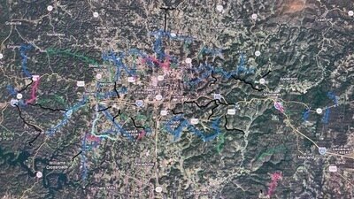
Map of my proposal: https://www.google.com/maps/d/edit?mid=1_ov-E-5bjAaoJ5GFn8rC_Jms1LV8iyE&usp=sharing
Sources...
--functional classifications, state aid eligibility and bike routes: https://tdot.maps.arcgis.com/apps/dashboards/0901655139694144a16f7812a52b4f36
--TDOT standards for rural collectors: https://www.tn.gov/content/dam/tn/tdot/engineering-production-support/documents/standard-drawings/roadway-standard-drawings/current/roadway-design-standards/RD11TS2.pdf
--TDOT standards for rural local roads: https://www.tn.gov/content/dam/tn/tdot/engineering-production-support/documents/standard-drawings/roadway-standard-drawings/current/roadway-design-standards/contextual-typical-sections/RDCTSR3.pdf
--TDOT standards for suburban collectors: https://www.tn.gov/content/dam/tn/tdot/engineering-production-support/documents/standard-drawings/roadway-standard-drawings/current/roadway-design-standards/contextual-typical-sections/RDCTSS2.pdf
--TDOT standards for suburban local roads: https://www.tn.gov/content/dam/tn/tdot/engineering-production-support/documents/standard-drawings/roadway-standard-drawings/current/roadway-design-standards/contextual-typical-sections/RDCTSS3.pdf
--2004-2024 Major Thoroughfare Plan: found on page 38 of the PDF (officially printed as page 32): https://putnamcountytn.gov/sites/default/files/downloadable/PutnamCountyLandUseandTransportationPolicyPlan.pdf
--Right-of-Way widths of Putnam County roads as of January 1, 2026: found on page 24 onwards of the PDF (officially printed as page 20 onwards): https://putnamcountytn.gov/sites/default/files/Full%20Commission%20Agenda%20Mar%202026.pdf

9
The Issue
Putnam County, Tennessee needs a new Major Thoroughfare Plan. The old one was intended to expire in 2024, was only legislatively binding for subdivision developers and seemingly relied on assumptions that the TDOT and Cookeville road department would build far more arterial roads bypassing the city core than they actually did. It also left some state aid roads and important truck routes off of the county's designated collector roads and failed to effectively sort the collector roads based on state aid eligibility and whether the road is truck-friendly or not.
I'm suggesting splitting the original Major Collector Roads and Minor Collector Roads into four separate major categories, too, with two unique categories. You don't have to read the finer details past the six classifications if it's too much, but please sign and share my petition if you agree!
Minor Collectors should be residential roads that are not on the state aid system nor key truck routes but have enough traffic to register on Google Maps traffic data, the main roads into subdivisions with at least 50 houses, through roads that fail other criteria but have an uninhabited segment or are part of TDOT’s functional classification but neither truck-friendly nor state aid roads, and the goal should be to widen them to a consistent 18 feet and to require subdivision developers to either widen them to thirty feet (three ten-foot lanes) or two ten-foot lanes with a ten-foot median.
Major Collectors should be residential roads that are on the state aid system. The goal should be to widen them to meet the TDOT's standards for rural local or collector roads (depending on how the official TDOT maps classify them), potentially even suburban local or collector roads if there's sufficient right-of-way for the sidewalks (and turning and bike lanes for collector roads) that that would entail. Developers should be required to reserve sufficient right-of-way to meet the TDOT's suburban collector road standards, starting out with a three-lane road with extra right-of-way for the standard four-lane divided highway in case traffic volumes increase.
Local Arterials (NOT to be confused with the Arterial Roads shown in the old Major Thoroughfare Plan, which are state routes) should be mixed-use roads that are on the state aid system, with a turning radius never below sixty-five feet to ensure a standard fifty-three foot tractor trailer can safely make every twist and turn. The goal should be to widen them to meet the TDOT's standards for rural local or collector roads (depending on how the official TDOT maps classify them), potentially even suburban local or collector roads if there's sufficient right-of-way for the sidewalks (and turning and bike lanes for collector roads) that that would entail. Developers should be required to reserve sufficient right-of-way to meet the TDOT's suburban collector road standards, starting out with a three-lane road with extra right-of-way for the standard four-lane divided highway in case traffic volumes increase.
Truck Routes should be mixed-use roads that are not on the state aid system, with a turning radius never below sixty-five feet to ensure a standard fifty-three foot tractor trailer can safely make every twist and turn. The goal should be to widen them to a consistent 20 feet and to require industrial or subdivision developers to widen them to at least 32 feet if there's at least 36 feet of right-of-way available in areas they're not developing, or to 26 feet if there's only 30 feet of right-of-way, and reserve sufficient right-of-way in developed areas for possible expansion to the aforementioned four-lane divided highways. The suggested Truck Routes can be further split into the Buffalo Valley Truck Route, Cookeville Boatdock Bypass Route, Cookeville to Gainesboro Truck Route, Burgess School Bypass Route, North Cookeville Bypass Route, Fisk Industrial Truck Route, Glade Creek Truck Route, Monterey Industrial Truck Route and Dripping Springs Turn Truck Route.
The part of Baxter Road north of Window Cliff Road should be classified as a Local Arterial Bike Route because it's part of an official bike route between Baxter and Sparta, with state aid being sought to widen it to a consistent 28 feet to meet rural state collector standards for roads with a bike route. Otherwise, this portion of Baxter Road should be treated the same as any other Local Arterials.
Window Cliff Road should be classified as a Local Bike Route because it's part of an official bike route between Baxter and Sparta, with my recommendation being to study the possibility of adding 4-foot bike lanes if traffic warrants it. Otherwise, treat as essentially any other minor collector road.
Apart from the Bike Route along Baxter Road and Window Cliff Road, here is every road in the other four categories and the recommended course of action. You can stop reading now if it's too long, but please sign and share this petition if you agree so far!
Local Arterials...
- Saint Mary's Road: post eastbound Speed Limit 35 sign and westbound Speed Limit 55 sign at Smith County line to clarify speed limit change - if Smith County approves and/or the TDOT approves a state aid project for clearer signage
- part of Ensor Hollow Road (south of Webster Road): post signs warning to Watch For Trucks Crossing Centerline at sharp curves
- part of Ensor Hollow Road (north of Webster Road): widen to a consistent 18 feet (seek state aid funding if necessary) and post signs warning to Watch For Trucks Crossing Centerline at sharp curves
- Spring Fork Road: no action recommended
- part of Hopewell Road (west of Indian Creek Road): post To Interstate 40 sign directing traffic towards State Route 96 southbound and Speed Limit 40 sign just west of Indian Creek Road
- Old Baxter Road: Widen to 22 feet by paving over existing gravel shoulders and laying new gravel shoulders beyond the extended pavement. Post Do Not Stop On Tracks signs on side roads with closely spaced railroad crossings (e.g. Monroe Henley Ridge Road) and Do Not Block Intersection signs at intersections with those same side roads. Seek state aid to install level crossing signals at Old Baxter Road crossing. Make #1 priority for snow removal to keep interstate detour route safe/open just in case (with the Stanton Road/Indian Creek Road/Hopewell Road truck route as the #2 priority if a separate westbound detour is established), and if that's not enough, ask the TDOT to designate Old Baxter Road and First Avenue North as part of State Route 141 or as a separate State Route 479 (with Stanton Road and the western parts of Indian Creek Road and Hopewell Road as a potential State Route 480 or realigned State Route 24) to ensure adequate winter maintenance.
- part of Cookeville Boatdock Road (southwest of Thomas Twin Oak Road): Post northbound stop sign at Austin Bottom Road and southbound stop sign at Baxter Road to improve safety and efficiency of Y-intersections. Post Truck Advisory Signs warning of insufficient turn radius to turn around on Austin Lake Road; if the owners of the Cookeville Boatdock won't let local businesses with driveways pointed the wrong way turn around, classify this as Major Collector south of Thomas Twin Oak Road.
- part of Baxter Road (south of Thomas Twin Oak Road): post Truck Advisory Signs warning of insufficient turn radius to turn around on Austin Lake Road; if the owners of the Cookeville Boatdock won't let local businesses with driveways pointed the wrong way turn around, classify this as Major Collector south of Thomas Twin Oak Road
- Ward Mill Road: Ask the TDOT about building the State Industrial Access Road to Anatolia Granite on top of existing Ward Mill Road and Nashville Highway to reduce right-of-way costs and ongoing property disputes and adding sidewalks and turning lane to bring up to suburban collector standards. Failing that, repeal truck ban if it's in violation of federal law requiring "reasonable access" within a mile of national highways (if not and the SIA isn't built here, reclassify this as Major Collector), widen to consistent 22 feet (seeking state aid if necessary) and lay new gravel shoulders beyond the extended pavement.
- part of Baxter Road (between Thomas Twin Oak Road and Window Cliff Road): post Truck Advisory Signs warning of insufficient turn radius to turn around on Austin Lake Road and warning that Thomas Twin Oak Road is the last safe place to turn to divert
- part of Old Gainesboro Road (near Jackson County line): no action recommended
- part of Cookeville Boatdock Road (northeast of Thomas Twin Oak Road): Widen to 24 feet (seek state aid if necessary), paving over existing gravel shoulders and laying new gravel shoulders beyond the extended pavement. Post Truck Advisory Signs warning of insufficient turn radius to turn around on Austin Lake Road and warning that Thomas Twin Oak Road is the last safe place to turn to divert.
- Cumby Road: no action recommended
- part of Ditty Road (northwest of State Route 135): Widen to 22 feet (seek state aid if necessary), paving over existing gravel shoulders and laying new gravel shoulders beyond the extended pavement - and move mailboxes to accommodate the wider road. Re-paint passing zone in high-visibility spot near Neely Road once road is widened enough to safely accommodate it again. Make the #4 priority for snow removal to ensure traffic between Baxter (and Gainesboro) and Sparta/Chattanooga is largely uninterrupted.
- part of Pippin Road (west of County Farm Road): Put up northbound stop signs at Plunk Whitson Road and southern end of County Farm Road concurrency to make Y-intersections safer and more efficient. Also, widen to consistent 20 feet (seek state aid if necessary) most of the way and 24 feet along County Farm Road concurrency, paving over existing gravel shoulders and laying new gravel shoulders beyond the extended pavement; road has insufficient right-of-way to meet state suburban collector road standards but can still be easily brought up to rural collector standards.
- part of Ditty Road (between S.R. 135 and Solon Jared Road): Ask developer to widen road to 32 feet or to two 11-foot lanes with 10-foot median and reserve 80 feet of right-of-way to support a five-lane road or four-lane divided highway (already asked to by Road Supervisor Randy Jones). Make the #4 priority for snow removal to ensure traffic between Baxter (and Gainesboro) and Sparta/Chattanooga is largely uninterrupted.
- part of Buffalo Valley Road (between Baxter and Cookeville): widen to 22 feet (seek state aid if needed), paving over existing gravel shoulders and laying new gravel shoulders beyond the extended pavement
- Plunk Whitson Road: Ask the TDOT for a traffic light or roundabout at the U.S. Route 70N intersection to improve safety. If the TDOT agrees and also adds sidewalks on Hawkins Crawford Road from the railroad crossing to U.S. Route 70N, ask for state aid to build sidewalks along Plunk Whitson Road to connect subdivisions there to the rail trail and meet state standards for suburban local roads.
- County Farm Road: Widen to consistent 22 feet south of Pippin Road concurrency and 24 feet along and north of Pippin Road concurrency (seek state aid if needed), paving over the existing gravel shoulders and laying new gravel shoulders beyond the extended pavement. Add northbound stop sign on Pippin Road at southern Y-intersection to make it safer and more efficient.
- Shipley Road: Post stop signs to create all-way stop at North Allen Road's oddly-shaped intersection. Also, build sidewalks (seek state aid if necessary) to meet state suburban local road standards and give subdivision streets pedestrian access to commerce in Cookeville and TTU.
- part of Ditty Road (southeast of Solon Jared Road): Widen to 22 feet (seek state aid if necessary), paving over existing gravel shoulders and laying new gravel shoulders beyond the extended pavement. Make the #4 priority for snow removal to ensure traffic between Baxter (and Gainesboro) and Sparta/Chattanooga is largely uninterrupted.
- South Lovelady Road: no action recommended
- West Whitehall Road: no action recommended
- Bartlett Road: no action recommended
- Howard Draper Road: post signs warning to Watch For Trucks Crossing Centerline at sharp curve
- Bob Lynn Road: no action recommended
- Free Hill Road: post Speed Limit 55 signs to clarify that the 30 mph speed limit in the Cookeville city limits doesn't apply out in the county
- East Whitehall Road: no action recommended
- Hutcheson Road: ask the TDOT for a roundabout at the intersection with S.R. 136 and Fisk Road to simplify it and make it more efficient and safer (already publicly supported by both 11th district County Commissioners Kathy Dunn and Darren Wilson, and already planned by the TDOT to be implemented - thank you!)
- Quinland Lake Road: no action recommended
- Old Bridge Road: no action recommended
- Paran Road: Widen to 22 feet (ask the TDOT for state aid if needed), paving over the existing gravel shoulders and laying new gravel shoulders beyond the extended pavement. Post eastbound Speed Limit 55 sign at Overton County line to clarify the speed limit change at the county line if Overton County approves and/or the TDOT agrees to a state aid project.
- Stone Seminary Road: no action recommended
- Seven Springs Road: post signs warning to Watch For Trucks Crossing Centerline at sharp curves
- Cherry Creek Road: Post Truck Advisory signs advising southbound trucks to turn right onto Walter Stone Road then left onto Walnut Grove Road to avoid S.R. 84's truck ban. Also, widen to 22 feet (ask the TDOT for state aid if needed), paving over the existing gravel shoulders and laying new gravel shoulders beyond the extended pavement.
- Phifer Mountain Road: widen to a consistent 20 feet and study possibility of converting Baker Mountain Road Y-intersection into a roundabout to simplify it (seek state aid from the TDOT if needed)
- part of Officers Chapel Road (east of State Route 111): post Speed Limit 55 signs to clarify that the 30 mph speed limit in Algood doesn’t apply outside of the town limits
- Buck Mountain Road: Widen to a consistent 24 feet (seek state aid if needed), paving over the existing gravel shoulders and laying new gravel shoulders beyond the extended pavement. Also, have the eastbound truck climbing lane terminate in a right turn lane onto White's Point Drive.
- part of Old Highway 42 (between Officers Chapel Road and Spring Creek Road): no action recommended
- part of Pleasant Ridge Road (west of Sheep Bluff Road): widen to consistent 20 feet (seek state aid from TDOT if needed), paving over the existing gravel shoulders and laying new gravel shoulders beyond the extended pavement
- part of Spring Creek Road (east of Old Highway 42): no action recommended
- Brotherton Mountain Road: Post Do Not Block Intersection and Do Not Stop on Tracks signs at intersections with side roads. Also, ask the TDOT for state aid to add a level crossing signal at the railroad crossing. Make the #3 priority for snow removal along with Woodcliff Road to ensure traffic between Algood and Monterey (and Knoxville) is largely uninterrupted. Last but not least, maintain the passing zone to ensure traffic between Algood and Monterey flows smoothly.
- Sheep Bluff Road: no action recommended
- part of Sand Springs Church Road (northeast of Rocky Point Road): no action recommended
- part of Sand Springs Road (southwest of Rocky Point Road): widen to a consistent 18 feet (ask for state aid if needed)
- Thorn Gap Road: no action recommended
- Stamps Shady Grove Road: post Watch For Trucks Crossing Centerline signs at sharp curves
- Dripping Springs Road: Widen to a consistent 18 feet (seek state aid if needed), paving over the existing gravel shoulders and spreading new gravel shoulders beyond the extended pavement. Also, replace southbound Speed Limit 35 sign at Cumberland County line with Speed Limit 55 sign to clarify the speed limit change across county lines if Cumberland County approves and/or the TDOT agrees to a state aid project.
- Jim Garrett Road: put up southbound Speed Limit 35 sign and northbound Speed Limit 55 sign at Cumberland County line to clarify that Cumberland County's posted 35 mph speed limit doesn't extend into Putnam County, if Cumberland County approves and/or the TDOT agrees to a state aid project
- Muddy Pond Road: put up southbound Speed Limit 45 sign and northbound Speed Limit 55 sign at Overton County line to clarify that Putnam County's posted 45 mph speed limit doesn't extend into Overton County, if Overton County approves and/or the TDOT agrees to a state aid project
- Elmore Road: no action recommended
Major Collectors...
- Webster Road: post No Thru Trucks sign due to insufficient turning radius at Ensor Hollow Road
- Rock Springs Road: Post No Thru Trucks signs. Study putting up speed cameras (seeking state aid if necessary) to enforce 25 mph speed limit consistently, given high non-compliance rate (especially if it's not raised on Stanton Road south of Leftwich Ridge Road or that increase doesn't significantly decrease Rock Springs Road's traffic volume). Only at S curves to comply with state law though.
- part of Buffalo Valley Road (between State Route 96 and S.R. 141): Post No Thru Trucks signs due to sharp curve near Buffalo Valley post office. Post Do Not Stop On Tracks signs on side roads (except Wallace Hollow Road and Doctor Smith Road). If Wallace Hollow Road is a public road, post stop or yield sign on it. Seek state aid to repave rough railroad crossing and install level crossing signals. Study making Doctor Smith Road one-way westbound to promote smoother, safer traffic flow.
- Clemons Ridge Road: post Speed Limit 55 signs to clarify the limits of 25 mph speed limit signs in connected subdivision
- Silver View Lane: widen loop at end to 18 feet (seek state aid if necessary) with two-way yield giving oncoming traffic the right-of-way or make loop at end one-way counterclockwise
- part of Hopewell Road (between Indian Creek Road and Rough Ridge Road): post eastbound No Thru Trucks sign just east of Indian Creek Road and westbound stop sign at Indian Creek Road intersection
- part of Hopewell Road (east of Rough Ridge Road): widen to 20 feet by paving over existing gravel shoulders and laying new gravel shoulders beyond the extended pavement (seek state aid if necessary)
- Austin Bottom Road: Put up warning sign that Austin Lake Road has too tight of a turn radius for trucks to turn around and eastbound stop sign at Goff Ridge Road to improve safety of Y-intersection. Put up Speed Limit 55 or Speed Limit 25 sign at DeKalb County line if DeKalb County approves and/or the TDOT agrees to a state aid project for signage, depending on whether the 25 mph speed limit west of Austin Lake Road is binding on the entire DeKalb County portion or just that segment.
- Academy Road: add all-way stop at Baxter Road to improve safety at low-visibility intersection (Commissioner Danny Holmes said he would ask outgoing Road Supervisor Randy Jones to do so on my behalf - thank you if so! - but as of August 4, 2026, I still saw no new stop signs nor plans to add them)
- Hawkins Crawford Road: Widen to 24 feet (seek state aid if needed), paving over existing gravel shoulders and laying new gravel shoulders beyond the extended pavement. Ask the TDOT for state aid to widen the railroad crossing to 24 feet and add a level crossing signal and sidewalks across and north of the railroad to meet state suburban local road standards and give Big Orange Drive and Plunk Whitson Road a pedestrian connection to the future rail trail. Also ask the TDOT to add traffic lights or a roundabout at the U.S. Route 70N intersection to improve safety.
- Cowan Road: no action recommended
- part of Bennett Road (north of Cowan Road): no action recommended
- Burgess School Road: study converting Y-intersection with Bunker Hill Road to roundabout to simplify it and make it safer and more efficient (ask the TDOT for state aid if needed), banning through trucks if it's built due to the insufficient turn radius a roundabout within existing right-of-way would have
- part of Bunker Hill Road (between South Lovelady Road and Burgess School Road): Study converting Y-intersection with Burgess School Road to roundabout to simplify it and make it safer and more efficient (ask the TDOT for state aid if needed), banning through trucks if it's built due to the insufficient turn radius a roundabout within existing right-of-way would have. Also post Speed Limit 55 signs to clarify that the 30 mph speed limit in Cookeville and 45 mph speed limit in White County don't apply in unincorporated Putnam County.
- West Thomas Allen Road: widen to consistent 20 feet (seek state aid if needed), paving over existing gravel shoulders and laying new gravel shoulders beyond the extended pavement
- part of Fairview Road (north of Whitehall Road): widen to consistent 22 feet (seek state aid if needed), paving over existing gravel shoulders and laying new gravel shoulders beyond the extended pavement, but be sure to maintain existing passing zone
- East Thomas Allen Road: Widen to consistent 20 feet (seek state aid if needed), paving over existing gravel shoulders and laying new gravel shoulders beyond the extended pavement. Also study adding all-way stop at X-intersection with Waterloo Road to improve safety.
- Brown's Mill Road: no action recommended
- part of Poplar Grove Road (southwest of Rocky Point Road): if right-of-way is sufficient on the state aid segment of Poplar Grove Road, build sidewalks (seek state aid if necessary) to meet state suburban local road standards and give subdivision streets pedestrian access to commerce in Cookeville
- Canada Flatt Road: Post stop sign at Poplar Grove Road to give Falling Water Road the right-of-way, ensuring the Y-intersection is safe and efficient. Also, widen to a consistent 18 feet (seek state aid if necessary).
- Rocky Point Road: if right-of-way is sufficient on the state aid segment of Poplar Grove Road for a westward extension of sidewalks, build sidewalks on urban part of Rocky Point Road (seek state aid if necessary) to meet state suburban local road standards and give Shelby Drive and Hyder Mountain Road pedestrian access to commerce in Cookeville and Poplar Grove Baptist Church
- Shady Lane Road: post No Thru Trucks sign to prevent truckers from accidentally running into Rocky Point Road's through truck ban
- Falling Water Road: give right-of-way at Poplar Grove Road/Canada Flatt Road by adding stop sign on Canada Flatt Road
- Mill Creek Road: post eastbound No Thru Trucks sign at U.S. Route 70N to prevent trucks from running into S.R. 84's truck ban
- Woodcliff Road: Post Do Not Block Intersection and Do Not Stop on Tracks signs at intersections with side roads. Also, ask the TDOT for state aid to add level crossing signals at the railroad crossings. Post eastbound No Thru Trucks sign at Brotherton Mountain Road/Stamps Shady Grove Road intersection to prevent trucks from running into Monterey's truck ban. Make the #3 priority for snow removal along with Brotherton Mountain Road to ensure traffic between Algood and Monterey (and Knoxville) is largely uninterrupted (except truck traffic until Stamps Shady Grove Road is cleared). Last but not least, widen to a consistent twenty feet (seek state aid if needed) by paving over the existing gravel shoulders and spreading new gravel shoulders beyond the extended pavement.
- Rock Springs Church Road: Post No Thru Trucks signs due to sharp curves with less than a 55-foot turn radius on Tyler Point Road across Overton County line. Also, widen to a consistent 18 feet (seek state aid from the TDOT if needed).
- Omaha Gap Road: widen to a consistent 18 feet (ask the TDOT for state aid if needed)
Minor Collectors...
- Medley Hill Road: Widen to a consistent 18 feet and pave the entire road with chipseal (due to flooding making asphalt concrete too expensive to be worthwhile), but still paint centerline and fog lines on road once gravel has had time to settle into chipseal and simply sweep off any loose gravel first to prevent paint from coming off. Block residents from lowering the speed limit on unpopulated portion of road northeast of Autrey Road below 35 mph to prevent a repeat situation of an unwarranted too-low-for-cruise-control speed limit on the unpopulated portion of a road similar to what happened on the uninhabited segment of Stanton Road south of Leftwich Ridge Road. Last but not least, add stop sign on Autrey Road and two stop signs on Carr Ridge Road due to low visibility.
- part of Martin Creek Road (west of Flatt Hollow Road): Widen to a consistent 18 feet, matching the three box culverts and portion of the road in Bloomington Springs. Post stop signs at Puncheoncamp Road and warning signs at the new all-way stop for turning traffic to yield to oncoming traffic from Jackson County, given the twelve-foot right-of-way on Puncheoncamp Road preventing widening it to two lanes nor passing on adjacent soil.
- Tightfit Road: Widen to a consistent 18 feet. Block residents from lowering the speed limit on unpopulated portion of road northwest of Tightfit Lane below 35 mph to prevent a repeat situation of an unwarranted too-low-for-cruise-control speed limit on the unpopulated portion of a road similar to what happened on the uninhabited segment of Stanton Road south of Leftwich Ridge Road. Post northbound No Thru Trucks signs at Old Baxter Road and Truck Traffic Prohibited signs between Tightfit Lane and Indian Creek Road due to hairpin curve with turn radius way under 55 feet, let alone 65 feet. Last but not least, add all-way stop at Indian Creek Road due to low visibility and frequent turns.
- part of Elmore Town Road (between Brown Lane Road and I-40 frontage road segment): widen to 18 feet
- Goff Ridge Road: put up Dead End sign at entrance and eastbound stop sign on Austin Bottom Road to improve safety of Y-intersection
- part of Martin Creek Road (between Flatt Hollow Road and Jess Rodgers Road): Widen to a consistent 18 feet (already in progress). Also, block residents from lowering speed limit on this uninhabited segment below 30 mph to prevent a repeat of a situation where the speed limit is unjustly low near the bottom and people would have to brake very hard to comply (which already happened on the uninhabited southern segment of Stanton Road).
- part of Elmore Town Road (along and northeast of I-40): put up stop or yield sign on P.O.W. Road and warning sign that P.O.W. Road ends in water
- part of Martin Creek Road (east of Jess Rodgers Road): no action recommended
- Maxwell Landing: no action recommended
- part of Oliver Way (south of Nunally Drive): no action recommended
- Coon Hunt Road: Post Speed Limit 55 signs to clarify that lower speed limits in Baxter town limits don't apply out in the county. Also, widen to a consistent 18 feet.
- part of Ball Hill Road (west of Medlin Road): Widen to a consistent 18 feet (seek developer fee if needed) and add two-way stop at intersection with Medlin Road so southbound/eastbound traffic has the right-of-way. Also, post Speed Limit 55 signs to clarify that the 35 mph speed limit on Old Mill Road doesn’t apply here.
- part of Medlin Road (north of Waterfall Drive): Widen to a consistent 18 feet (seek developer fee if needed) and add two-way stop at intersection with Medlin Road so southbound/eastbound traffic has the right-of-way. Address poor drainage and insufficient mailbox clearance on the segment that has already been widened by the developer south of Nash Road.
- part of Medlin Road (between Waterfall Drive and Canoe Way T-junction): Widen to a consistent 18 feet, ideally seeking a developer fee. If possible, ask the subdivision developer to fund two ten-foot travel lanes between Waterfall Drive and Canoe Way and left-turn lanes onto both side roads.
- part of Prosperity Drive (south of Raven Crossing): no action recommended
- road name TBD (off of U.S. Route 70N): no action recommended - unless the TDOT requires developer to use Leffew Road, in which case ask developer to widen Leffew Road to consistent thirty feet or to two ten-foot lanes with a ten-foot median
- Clemmons Road: When/if the TDOT adds turning lanes where U.S. Route 70N meets State Route 291/Double Springs Road, ask the TDOT to make the intersection with Clemmons Road right-in, right-out to minimize the risk of head-on collisions in the new turning lane. Traffic could instead go on Norton Drive to turn left.
- road name TBD (off of Window Cliff Road): no action recommended
- part of South Pointe Road (divided highway at Bennett Road intersection): no action recommended
- part of Bennett Road (south of Cowan Road): no action recommended
- Chester King Road: no action recommended
- Benton Young Road: no action recommended
- West Cemetery Road: no action recommended
- part of Bunker Hill Road (north of Burgess School Road): Study converting Y-intersection with Burgess School Road to roundabout to simplify it and make it safer and more efficient, banning through trucks if it's built due to the insufficient turn radius a roundabout within existing right-of-way would have. Also post Speed Limit 55 signs to clarify that the 30 mph speed limit in Cookeville and 45 mph speed limit in White County don't apply in unincorporated Putnam County.
- part of Whitaker Springs Road (between Fisk Road and Bowser Road): Post Speed Limit 55 signs to clarify that the 25 mph speed limit east of Bowser Road is specific to the subdivision. Also, post eastbound No Thru Trucks sign to match the westbound sign on Gibbons Road.
- part of Bowser Road (north of Gibbons Road): no action recommended
- part of Whiteaker Springs Road (east of Bowser Road): no action recommended
- part of Oak Park Drive (south of Whiteaker Springs Road): no action recommended
- Gibbons Road: no action recommended
- Mirandy Road: no action recommended
- Bob Bullock Road: no action recommended
- part of Hickory Cove (between Bradshaw Boulevard and Bob Bullock Road): no action recommended
- Old Walton Road: no action recommended
- Old Qualls Road: no action recommended
- Bridgeway Drive: no action recommended
- part of Mountain Top Lane (northeast of Howell Lane): no action recommended
- part of Old Highway 42 (south of Officers Chapel Road): no action recommended
- part of Old Highway 42 (north of Spring Creek Road): no action recommended
- The Lane Road: post Do Not Block Intersection and Do Not Stop On Tracks signs at Green Mountain Road and Brotherton Mountain Road intersections
- parts of Brotherton Drive (divided highways at both intersections with The Lane Road): no action recommended
- part of Pleasant Ridge Road (east of Sheep Bluff Road): post eastbound No Thru Trucks signs on Pleasant Ridge Road just east of Sheep Bluff Road to prevent truckers from using Board Valley Road and accidentally running into State Route 84's truck ban
- Board Valley Road: Post Speed Limit 55 signs at each end and Speed Limit 35 sign going into White County if White County approves to clarify that the 35 mph speed limits in White County and on Pleasant Ridge Road don't apply here. Block residents from lowering the speed limit on unpopulated portion of road south of Beech Grove Road below 35 mph to prevent a repeat situation of an unwarranted too-low-for-cruise-control speed limit on the unpopulated portion of a road similar to what happened on the uninhabited segment of Stanton Road south of Leftwich Ridge Road.
- part of Cumberland Cove Road (northeast of unnamed, unbuilt loop street): no action recommended
- Hillwood Street: no action recommended
- Cumberland Lakes Drive: no action recommended
Truck Routes...
--Buffalo Valley Truck Route...
----part of Indian Creek Road (west of Stanton Road): Widen to consistent 20 feet and post To Interstate 40 sign directing traffic onto Hopewell Road westbound. Post Speed Limit 35 sign just west of Stanton Road. After widening project is finished, move Narrow Road Watch For School Buses sign east of Stanton Road.
----part of Stanton Road (south of Leftwich Ridge Road): Widen to consistent 20 feet. Post To Interstate 40 sign directing traffic onto westbound Indian Creek Road and signs warning to Watch For Trucks Crossing Centerline at sharp curves. Study raising 25 mph speed limit to 30, 35, 40, 45 or 50 mph if three-quarters of households with a Stanton Road address approve then lock the newly raised speed limit to prevent further changes, given the high noncompliance rate and this particular segment of road south of Leftwich Ridge Road having zero residents. If the speed limit change fails, put up speed cameras to ensure consistent enforcement/compliance. Only at S curves to comply with state law though. Last but not least, raise road in the floodplain to the same elevation as the bridge over Big Indian Creek and either build a third bridge or series of parallel culverts to ensure proper drainage, and add a culvert under the driveway to the barn and deeper drainage ditch on the east side of the road between the two bridges to prevent the smaller creek from carving a rut in the road when it floods.
----part of Stanton Road (north of Leftwich Ridge Road): Widen to consistent 20 feet. Post To Interstate 40 sign directing traffic onto southbound Stanton Road if the TDOT approves, Truck Advisory signs as far east as First Avenue North warning of the insufficient turn radius on all three alternate routes (State Route 96 intersection, Rock Springs Road intersection and Indian Creek Road between Tightfit Road and Maddux Ridge Road) and signs warning to Watch For Trucks Crossing Centerline at sharp curves.
--Cookeville Boatdock Bypass Route: Thomas Twin Oak Road: Widen to consistent 20 feet.
--Cookeville to Gainesboro Truck Route: part of Pippin Road (east of County Farm Road): Put up northbound stop sign at southern end of County Farm Road concurrency to make Y-intersection safer and more efficient.
--Burgess School Bypass Route: part of Bunker Hill Road (south of South Lovelady Road): Widen to a consistent 20 feet, paving over the existing gravel shoulder. Also post Speed Limit 55 signs to clarify that the 30 mph speed limit in Cookeville and 45 mph speed limit in White County don't apply in unincorporated Putnam County.
--North Cookeville Bypass Route...
----Shipley School Road: Widen to consistent 20 feet, paving over existing gravel shoulders.
----North Allen Road: Widen to consistent 20 feet, paving over existing gravel shoulders.
----Kinniard Road: Widen to consistent 20 feet, paving over existing gravel shoulders. Also, post Speed Limit 55 signs to clarify that the 30 mph zone in Cookeville doesn't apply in unincorporated Putnam County.
----Dale Lane: Widen to consistent 20 feet (32 feet where the paved shoulders exist but are unmaintained), paving over existing gravel shoulders.
----part of Whitaker Springs Road (west of Fisk Road): Post Speed Limit 55 signs to clarify that the 25 mph speed limit east of Bowser Road is specific to the subdivision. Also, widen to a consistent 20 feet, paving over the existing gravel shoulders.
--Fisk Industrial Truck Route: Fisk Road: Ask the TDOT for a roundabout at the intersection with S.R. 136 and Hutcheson Road to make it simpler, safer and more efficient (already done and planned). Also, widen to consistent 20 feet, paving over the existing gravel shoulders.
--Glade Creek Truck Route: Glade Creek Road: Widen to a consistent twenty feet, paving over the existing gravel shoulders.
--Monterey Industrial Truck Route: Industrial Drive: no action recommended.
--Dripping Springs Turn Truck Route: Copperhead Drive: Widen to a consistent 20 feet, paving over the existing gravel shoulders.
Map of my proposal: https://www.google.com/maps/d/edit?mid=1_ov-E-5bjAaoJ5GFn8rC_Jms1LV8iyE&usp=sharing
Sources...
--functional classifications, state aid eligibility and bike routes: https://tdot.maps.arcgis.com/apps/dashboards/0901655139694144a16f7812a52b4f36
--TDOT standards for rural collectors: https://www.tn.gov/content/dam/tn/tdot/engineering-production-support/documents/standard-drawings/roadway-standard-drawings/current/roadway-design-standards/RD11TS2.pdf
--TDOT standards for rural local roads: https://www.tn.gov/content/dam/tn/tdot/engineering-production-support/documents/standard-drawings/roadway-standard-drawings/current/roadway-design-standards/contextual-typical-sections/RDCTSR3.pdf
--TDOT standards for suburban collectors: https://www.tn.gov/content/dam/tn/tdot/engineering-production-support/documents/standard-drawings/roadway-standard-drawings/current/roadway-design-standards/contextual-typical-sections/RDCTSS2.pdf
--TDOT standards for suburban local roads: https://www.tn.gov/content/dam/tn/tdot/engineering-production-support/documents/standard-drawings/roadway-standard-drawings/current/roadway-design-standards/contextual-typical-sections/RDCTSS3.pdf
--2004-2024 Major Thoroughfare Plan: found on page 38 of the PDF (officially printed as page 32): https://putnamcountytn.gov/sites/default/files/downloadable/PutnamCountyLandUseandTransportationPolicyPlan.pdf
--Right-of-Way widths of Putnam County roads as of January 1, 2026: found on page 24 onwards of the PDF (officially printed as page 20 onwards): https://putnamcountytn.gov/sites/default/files/Full%20Commission%20Agenda%20Mar%202026.pdf
The Decision Makers
Petition Updates
Share this petition
Petition created on June 19, 2026