The South African Astronomical Observatory (SAAO) recently celebrated its 200th birthday. As a National Heritage site, and in line to be declared a UNESCO World Cultural Heritage site, you would think its concerns about the River Club development, proposed to take place within some metres of the SAAO site would have some weight in decision-making on the development. Not so for the Municipal Authorities and the Department of Environmental Affairs and Development Planning, who seem to think that putting up a raft of densely located buildings between 20m and 46m in height on the adjacent erf is just fine. In the words of the Municipal Planning Tribunal, “the elevated height in Precinct 2 enables a sensitive bulk distribution where it is deemed most appropriate.”
Really?
Let’s examine exactly what it means for the SAAO.
As an Observatory and as a heritage icon, views are critically important for the SAAO, both views from the SAAO (outward-looking) and views of the SAAO (towards the Observatory). Although the “noon gun” on Signal Hill is no longer part of determination of time for the wider community, the visual connection between the Observatory and Signal Hill that enabled the Observatory to keep the time for the public is part of the heritage history that underlies the SAAO’s heritage status. (Historically, the Noon Gun was set off at exactly 12 noon by a signal from the SAAO as the timekeeper; nowadays that signal is electronic). Moreover, the Observatory buildings are set within a green matrix and tree canopy well suited to the concept of a parkland setting associated with the adjacent riverine corridor.
When the developer first proposed a set of massive buildings on precinct 1 opposite the SAAO, the SAAO reacted with dismay to the developers’ claim that the presence of the SAAO was of “low contextual significance” to the proposed project, because it was “rendered invisible” by the trees on-site. “First of all”, the SAAO said, “the statement is patently false, the SAAO is not invisible from the River Club. Secondly, and more importantly for the purposes of the proposal, the logic of the invisibility argument is strange: surely the point should be that the River Club site is very clearly visible from the Observatory. And, indeed, it will be even more so with 4 – 12 story buildings and more lights. The SAAO strongly objects to being brushed aside as an irrelevant factor…”
The developers responded by putting in a larger set-back and reducing the heights of the buildings in Precinct 1 somewhat. Precinct 1 is the part of the River Club land opposite the SAAO to the west across the Liesbeek River. Nonetheless, the developers’ concession still left 11 buildings proposed on precinct 1 to the west ranging from 20 to 44 m in height, and this also meant that the heights of those buildings in precinct 2 to the north increased even further.
Not surprisingly, the SAAO commented in September 2019 that the mitigation of the heritage impact of the scale and form of building footprints facing onto the riverine corridor and alongside the Observatory are still insufficient.
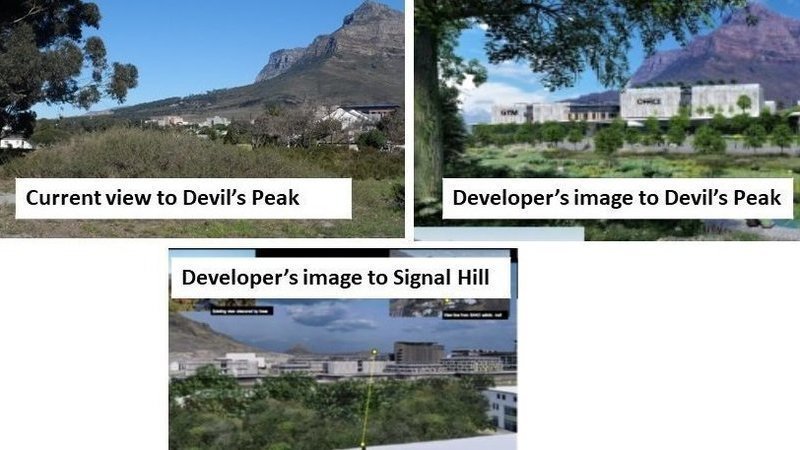
In the image above, you can see the photo on the upper left which shows the reality of the current view from the SAAO grounds across the River Club. Immediately across the Liesbeek River, some 180m away is the River Club Building, a two-story white structure. The building is approximately 12m high at its apex. Behind the River Club building, an 8-story facebrick Office complex for the Black River Park, approximately 25m in height is visible some 450m away. The line of sight to the Black River Complex is more or less at the height of the apex of the River Club building. Most of the lower slopes of the mountain are visible, reinforcing the connection between the Observatory and the mountain as well as to the suburb of Observatory.
What the development proposal intends to place on Precinct 1 is set of buildings which range from 20m to 44m in height, approximately twice to three times or more the height of the current River Club building. It should be clear that if you double or treble the heights of new buildings, compared to the existing River Club building, the impact on the SAAO’s visual connection to the mountain and horizon will be severely impacted.
Take a look above at the artist’s image from the developer’s application on the right-hand upper side which presents the equivalent to what we see in the photo. It demonstrates the extent to which visibility of the mountain is much reduced. On the left side of that image, most of what is visible of the lower slope currently is lost – the UCT campus and the trees around Rhodes Memorial which would normally occupy the silhouette of the lower slopes of the mountain to the south are completely eclipsed by a 20m tall building containing what is slated to include a gym. On the right of the artist’s image, all visibility of the lower slopes is lost due to the 44m tall building looming upward. Moreover, one is always looking over buildings which are not hidden by trees in order to see the upper parts of the mountain.
As the SAAO stated, “the concerning fact remains that the vertical angle … [of] … the closer obscuring buildings will limit the visual-spatial field currently experienced from the Observatory. The effect is compounded by the ‘urban wall’ created by the proposed densely packed individual buildings blocking any horizontal viewing angle between adjacent buildings from any single proximity vantage point at the Observatory.”
And for the SAAO to see the Noon Gun on Signal Hill, the developers present an artist’s image of the line of sight to Signal Hill, which is only achievable from the roof of the Observatory building, and over an array of behemoth buildings 32m to 45m tall. This is evident in lower window in the image above. They do not provide a view from the level of the grounds of the SAAO towards Signal Hill.
Visitors to SAAO, who aren’t able to climb to the top of the building, will not be able to see through the 32 - 44m tall buildings on Precinct 1, not to mention the other tall buildings housing the Amazon campus in Precinct 2.
As for light pollution from the myriad of buildings the River Club plans to place on the site, which is not what you want affecting a functioning Observatory, there is no mention of what can be done to mitigate that by the developers or the Municipal Planning Tribunal – simply because there is no way to mitigate such pollution.
How exactly that is ‘sensitive treatment’ of heights as espoused by the Municipal Planning Tribunal is simply a mystery of Land Use planning decisions in the City of Cape Town and the language they use to justify unjustifiable decisions.
The “hemming in of the landscape setting of the Observatory” by the development continues to have what the SAAO describe in a rather understated way as “the negative impacts of the proposed development in Precinct 1 on the landscape setting of the Observatory.” Moreover, the SAAO note that “the Observatory cannot be solely seen as a standalone entity … but should be considered as an integral part of the wider TRUP area … According to the National Khoisan Legacy Project, the site has been identified as an important area for the First Nation people. Importance should be granted to the intangible heritage significance of the entire Liesbeeck Corridor. Ideas regarding concepts to develop an attraction connecting the unique and fascinating cultural and historical continuum from First Nation people through Colonial history to modern science reaching to the stars, has not been given even a chance to date.”
We agree entirely.