
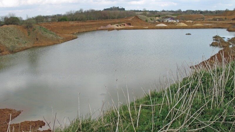
View of the permanently flooded western end of Wicklesham Quarry during mineral extraction.
Below are summary extracts from 35 pages of objections by residents of Faringdon and the Western Vale to the huge proposed industrial- commercial development on Faringdon’s Site of Special Scientific Interest- Wicklesham Quarry. This was the FOURTH consultation in 18 months! Strong objections have been made on the grounds of loss of green space and harm to the MidVale Ridge landscape; impacts on the road network; fake biodiversity claims by the applicant; conflict with the Local Plan, NPPF and Minerals and Waste Policies; contradictions and inaccuracies in the application forms; and evidence that this application has a hidden agenda.
Many people stress the fact that reducing the height of the seven enormous buildings has no impact on numerous grounds of objection. The proposal represents a huge area of urban sprawl outside Faringdon’s development boundary in an area of pristine landscape - in conflict with the Local Plan. It is completely at odds with the MidVale Ridge landscape – which Eric Pickles ruled a few years ago was grounds for refusing housing at Humpty Hill – and out of place for Faringdon itself. It will destroy a site of exceptional biodiversity in West Oxfordshire Heights Conservation Target Area (CTA) and put an end to future research on the Faringdon Sponge Gravels at one of the UK’s most unique and historic Sites of Special Scientific Interest.
Extracts from objections are linked under themes many people referred to. You can find them at: https://myeplanning.oxfordshire.gov.uk/Planning/Display/MW.0151/23#undefined (Select ‘Documents’ & look for REDACTED Reps 4th Consultation May 25)
DOCUMENTS ARE INCONSISTENT AND CONTRADICTORY
- Contrary to Faringdon Council's claim that it is a 'brownfield site' (FNP Basic Conditions Statement) and the applicant's description of a 'former industrial quarry', Wicklesham is restored agricultural land.
- errors in the latest documents make it unclear what is being proposed.
- why is a data centre mentioned in the CIL but not in the application form?
- deck parking as no taller than 15m but the section Design principles: Building scale (p.13) states deck parking is 12m. Which is correct?
- it would be helpful to have access to documents that are correct and accurate.
- conflict between carpark development, number of active users/employees and the traffic it would generate. This constant change in the 'plans' suggest obfuscation of purpose which makes it difficult to truly evaluate the proposal.
THIS DEVELOPER HAS FORM: THERE IS NO EVIDENCE OF NEED FOR EMPLOYMENT LAND - APPLICATION SEEKS TO JUSTIFY EVEN MORE URBAN EXPANSION
- There is no end user for this development and no proven need for whatever the applicants currently claim the site would be used for. The site will either end up with a retail site or more lucrative housing. Neither of which is needed in Faringdon. The town centre has already been killed off by the out of town supermarkets.
- the old Rogers Concrete site is available for employment use. This site is plainly much better related to Faringdon.
- What's needed is development of brown field abandoned areas
- The aim of the applicant is not to develop something to do with life sciences. That is a masquerade simply to secure an outline permission.
- The application (was) originally for B2 and B8 classes (industrial) now includes class E which means the development can be converted to something else including C3-housing. The current developer has previous form on this: the 4&20 site allocated for industrial development was changed to retail (and is now developed as such) so killing off Faringdon Town Centre for both business and tourism.
- Vale of White Horse District Council’s ‘Call for Land’ shows that the whole of Wicklesham Farm (i.e. a large area of land beyond Wicklesham Quarry) has been put forward as a proposed development site – an area that would increase dramatically the size of Faringdon.
- Wicklesham quarry is “a sprat to catch a mackerel” outside the development boundary of Faringdon.
LOSS AND DAMAGE TO LANDSCAPE AND COUNTRYSIDE
- will take away from much needed green space and everything that entails
- an eyesore in an existing place of beauty
- if this goes ahead it is yet somewhere else taken away from our every decreasing mental health space.
- the town has already lost much of its green space to housing developments in the last five years and a building of this scope would further destroy residents' access to green spaces, the quarry being bordered by many popular walking routes
- town relies largely on tourism from sites of interest like the Folly, the view from which will be marred by these buildings even if their height is reduced
- there are other suitable sites that won't infringe the landscape
- Faringdon is a market town and does not want to turn into a concrete jungle
- It will all stick out like a sore thumb and look and feel dreadful
- Inappropriate urban development in an area of high landscape value-the National Character Area of the Midvale Ridge (LP Core Policy 44, OCC CS M10, NPFF 187)
- the rural location and the seclusion that this brings along with the enjoyment of the wildlife. All of this will be ruined/compromised and destroyed if the proposed site is agreed
- This proposed construction will kill local wildlife and ruin people's enjoyment of the area
- The proposed size of the units & the scale of the development is totally out of character in the Vale - the view towards the historic White Horse will be marred & it would be a shocking eyesore
- There has been a pitiful attempt to conceal the true harmful impact this proposed development will have on the natural environment, the local landscape, the rare wild life and the wellbeing of the local population whose lives are enriched by living around, and accessing the natural environment.
- completely inappropriate in form, scale and height
- a totally inappropriate application for Faringdon and surrounding area
CONFLICT WITH PLANNING POLICIES
- The proposal is in conflict with the aims of planning conditions for restoration, aftercare and planned afteruse of Wicklesham Quarry for agriculture in keeping with the surrounding landscape (Policy M10, NPPF 223).
- Outside the development boundary of Faringdon -a strategic policy- and in conflict with the Local Plan (LP CP4, NPPF 13, PPG 004).
- In conflict with the Strategic Objectives of the Local Plan. The Vale of White Horse District Council definitively rejected the evidence of Faringdon Council's Neighbourhood Plan in 2016 in the Matter 10 Hearings on the 2031 Local Plan (SO3, SO6).
- This is not a ‘local development’. It is a major strategic development that undermines the spatial strategy and objectives of the 2031 Local Plan and is in conflict with the National Planning Policy Framework (NPPF Para 13, PPG 004, SO3, SO6).
- A neighbourhood plan cannot be used to justify a major strategic development.
- The proposed development is contrary to Policy M10 – Restoration of Mineral Workings.
- Faringdon Neighbourhood Plan policy 4.5B is contrary to the 2031 Local Plan Spatial Strategy and Strategic Policies, and the National Planning Policy Framework
- The proposed development would have adverse impacts by reducing, impeding and/ or displacing the natural flow of the aquifer contrary to Policies C3 and C6.
- The development is contrary to Local Plan CP 46 (Conservation and Improvement of Biodiversity) and OMWCS C7 (Biodiversity and Geodiversity)
- The High Court ruled In 2017 that Faringdon Neighbourhood Plan failed to meet the basic conditions (Case No. CO/5690/2016): Policy 4.5B was in ‘manifest conflict’ with the strategic policies of the Local Plan, because Wicklesham Quarry was outside the development boundary in open countryside (Policy GS2, PPG 065).
- ‘Only a draft neighbourhood Plan or Order that meets each of a set of basic conditions can be put to a referendum and be made.’ NPPF Para 065
- South and Vale Joint Local Plan 2041 (under examination): Policy SP5 – A Strategy for Faringdon: ‘Neighbourhood development plan reviews are expected to provide new employment opportunities and improve the building stock within existing employment sites and brownfield sites within the built-up area.’
- Policy 4.5B is contrary to Local Plan Core Policy 20: Spatial Strategy for the Western Vale Sub-Area: which includes Core Policy 4 – The Development Boundary; Core Policy 6 – Strategic Employment land; Core Policy 46 - Site of Special Scientific Interest; SO3 – The Spatial Strategy
IMPACTS ON THE ROAD NETWORK
- Unquestionable impact on a tremendously busy, dangerous and congested road: the A420
- There are enough accidents on this road without adding to it
- This development will completely change the character of the Vale villages of Longcot Fernham and Shellingford due to the change in traffic movements.
- Unsustainable impacts on the local road network (OCC CS M10, A420 Route Strategy, SO3, SO4)
- Will make the entry and exit to the farm dangerous and will increase the incidence of RTCs and probable fatalities on the A420.
- the A420 simply cannot cope with any more vehicles.
- traffic impacts would be detrimental to residents of the town and encourage rat-running.
- The road junction between Fernham and the A420 is already dangerous and difficult to enter and exit.
- unacceptable impacts on the local road network, serious safety concerns, and inconsistency with strategic planning policies.
- 2015 A420 Route Strategy highlighted the urgent need for improvements at key junctions, including Coxwell Road-A420, the Park Road roundabout, and Fernham Road. Nearly ten years later, these upgrades have not been implemented. Congestion, rat-running, and frequent accidents are now commonplace.
- The A420 is Oxfordshire's most hazardous road. Between 2009 and 2014, there were 157 recorded accidents, 5% of which were fatal. By 2018, the number had jumped to 595 accidents over five years, with fatalities and serious injuries continuing to rise.
- Park Road roundabout. This roundabout already suffers from severe delays, and the proposed changes* will only heighten congestion and safety risks. (*a right-turn junction across the A420, with traffic signals and a crossing for pedestrians and horses)
- The A420 Route Strategy explicitly aims to prevent the corridor from becoming a focus for development. This proposal directly undermines that goal by introducing substantial industrial and commercial traffic to an overstretched road network.
- It is deeply troubling that the County Council's Highways Officer has withdrawn their objection despite clear evidence of safety hazards and policy conflicts.
- a new accident hotspot.
- unsustainable, dangerous, and fundamentally at odds with the A420 Route Strategy.
- access arrangements which add to the already overloaded route of the A420 - the most dangerous road in the county.
- impact on the downland villages of Shellingford, Fernham and Longcot. Any problems on the A420 cause a rat run through these small villages which all have nurseries or schools.
- This development affects widespread communities adversely and will be the cause of more fatalities, more pollution and the destruction of a swathe of small thriving villages.
- (Will) attract people from larger towns to commute & add to the already overstretched road systems
- impact on the local road network and the clear conflict with established transport policy.
- The 2015 A420 Route Strategy identified the urgent need for significant short- to medium-term improvements at three key junctions in Faringdon: Coxwell Road-A420, Park Road roundabout, and Fernham Road. These locations were recognised as critical to maintaining safe and efficient traffic flow along the A420. Nearly ten years on, none of these improvements have been delivered.
- the number of serious injuries and fatalities continues to grow.
- The proposed commercial and industrial use would generate significant additional traffic, including HGVs, at an already overburdened section of the A420.
- undermines the long-term aims of sustainable and safe transport planning for the region.
- Approval of this scheme risks creating a new accident blackspot and setting a dangerous precedent for further unsustainable development along the A420.
- It would significantly harm the local transport network and public safety
- Excess traffic would make an already terrible traffic situation even worse.
- The number of accidents and fatalities on the A420 in the near vicinity and the number of times it has needed to be closed suggests it is at breaking point.
- I have witnessed many near accidents with traffic turning right as they cross an already busy intersection.
- delays, diversions, and accidents have become daily occurrences, indicating a complete failure to deliver the infrastructure required to support any additional development.
- The A420 is already the most dangerous road in Oxfordshire
- Park Road roundabout. This roundabout already suffers from heavy congestion. The proposed junction design will further compromise traffic flow and increase the likelihood of accidents, posing unacceptable risks to road users.
- Inexplicable Withdrawal of Highways Objection
- The withdrawal of the County Council Highways Officer's objection is deeply concerning, particularly in light of the substantial evidence highlighting safety risks and policy breaches. This decision lacks transparency and is seen by many local residents as unjustified and potentially dangerous.
- The planned new access to the site from the A420 is unsafe, on a road which already sees an average of four deaths a year.
- a huge increase in traffic which is dangerous for cyclists, pedestrians, and horse riders in this rural landscape
- Introducing industrial and commercial traffic on such a scale runs counter to strategic planning objectives for the area and undermines long-term transport and land-use goals.
- The proposed development will further endanger the lives of local people who have no choice but to use it.
HABITAT AND BIODIVERSITY
- biodiversity claims and net gains assessments are flawed and inaccurate
- This habitat cannot simply be recreated somewhere else.
- Under NERC Act 2006 s40 ‘a public authority must… further the general biodiversity objective’
- The applicant’s claims that Wicklesham Quarry ‘is a landscape of relatively limited biodiversity conservation interest’, and ‘has negligible potential as Great Crested Newt terrestrial habitat’ are not consistent with: 1. TVERC’s Biodiversity Report for Wicklesham Quarry; 2. photographs of the healthy newt population, including Great Crested Newts, a Protected European Species; 3. evidence of at least one pond that is present all year round; 4. water along the southern length of the quarry that is identifiable as “The nearest watercourse … indicated to be an underground river located in the south of the site” (Goundtech Report); 5. prolonged, extensive flooding and water bodies over the past six months, which are part of a regular pattern of flooding and result from the “underground river”. This evidence should have led to surveys and assessments, which the applicant has not carried out.
- wildlife such as pollinators, small birds and reptiles, will be negatively impacted.
- It would permanently damage or destroy the habitat of Wicklesham's European Protected Species (Great Crested Newts) and the exceptional biodiversity recorded by TVERC (CP46, NPPF paras 188, 192).
- It would cause permanent damage to West Oxfordshire Heights Conservation Target Area, and the Priority Habitat of 'aquifer-fed fluctuating water bodies' on which much of its biodiversity depends (CP 46, OCC CS M10, NPPF para 188, 192).
- The farm protected such sites when under subsidies and now want to disregard it for financial gain.
- Despite 'drought' conditions over the last few months significant parts of the site have remained underwater at Lake Wicklesham (at times ~50%), even resulting in Swans nesting at the site.
- there has not been a real assessment of flooding risk at the site which is constantly underwater.
- The biodiversity reports are not available on the planning website, yet are a requirement for the assessment of the application.
- The Ground Conditions (1) Report submitted 2/11/23 states that an aquifer or ‘underground river’ lies beneath Wicklesham Quarry.
- Wicklesham Quarry’s biodiversity and Priority Species are clearly linked to the presence of the aquifer and the quarry’s protected water resources- including terrestrial mammals, birds, insects and amphibians including GCNs.
- The proposal would be contrary to Policy C4: Water Environment. The aquifer has significant value for habitats and wildlife in Wicklesham Quarry. Contrary to statements by the applicants and their ecologist, the quarry has not been ‘drier’ in recent years.
- The aquifer rises at least twice a year and the quarry remains flooded for weeks or months at a time.
- Wicklesham Quarry has water bodies of different types and holds water all year round. Ponds, eutrophic water bodies and ‘aquifer-fed fluctuating water bodies’ are Habitats of Principal Importance under NERC s41.
WICKLESHAM’S GEOLOGICAL SITE OF SPECIAL SCIENTIFIC INTEREST (SSSI)
- This development would permanently damage the Site of Special Scientific Interest, which is the whole of Wicklesham Quarry including the base.
- Natural England states that almost the whole of the SSSI would be de-listed if it were built on. The UK’s relevant leading scientific bodies have objected to the proposal. The quarry base conceals important geological research resources (CP46, OCC CS M10, NPPF Para 193).
- Site of Special Scientific Interest which would be destroyed forever if this large development happened
- Prestigious environmental & scientific organisations have proved & supported this site as one of rare & irreplaceable importance.
- Wicklesham Quarry is an important SSSI. This development is not suitable for the surroundings & will trash an incredibly important site.
- this proposed development is totally inappropriate for this rural environment, which is of special scientific significance, so, it should be thrown out, in principle
- a Site of Scientific Interest (SSSI) and should not be built upon with this Proposed Development at all!
- the Quarry area as such seems inappropriate for development, with its riches of wildlife both present and prehistoric.
OTHER COMMENTS
- We feel let down by the planning system to have allowed the application to have proceeded thus far and in full view of local objections to the scale and nature of the proposed development.
- little benefit to this development and plenty of negatives to both the wellbeing and health of residents, local wildlife, and the likely drop in ability of small business relying on foot trade to survive, both in Faringdon itself and in the surrounding villages.
- It seems that these objections are raised every six months or so, and yet another application is put in which ignores them.
- alterations to the application regarding height does not mitigate any objections that I have made
- The site would be better suited to being protected and adding facilities for visitors, scientific research and holiday makers. This would also boost the local economy without destroying this unique and beautiful site of Special Scientific Interest.
- as a resident of Faringdon I strongly object to the proposed development of the Wicklesham Quarry site.
- On every level it is an unnecessary, undesirable & environmentally disastrous proposal.
- These plans do not reflect or support the needs of local residents in any way.
- The issue has dragged on for over a decade which leads one to think there are some serious questions to be asked why?
- opportunistic and unjustifiable proposal
- This former quarry should be returned to agricultural land as per the original clause to quarry the agricultural land and return it to its previous use. Leaving room for nature to thrive and all species have their particular natural habitats and needs.
- The guardians of the local environment are each one of us personally, as a community, as the council (as elected members as our representatives), and the Councillors personally at Oxfordshire County Council Planning.
Look out for updates soon on the ‘latest’ consultation on the applicant’s amendments- which include a 50% reduction in parking! The further consultation ends on 17 July.
YES! - There are YET MORE issues on which to base important NEW objections.