
Protect Dronfield Woodhouse
The Issue
Please note - if you give money to change.org as part of signing the petition, it doesn't come directly to us, instead promotes the petition on change.org.
To support us directly - https://pay.collctiv.com/dronfield-woodhouse-green-belt-25038
When signing, please double check the postcode, as we have seen cases of a default postcode being used, and while all signatures are welcome, the most powerful are those in s18.
Thanks!
Protect Dronfield Woodhouse - Object to Land North of Dronfield Woodhouse Being Developed and Removed from the Green Belt
We, the undersigned, object to:
Any planning application submitted by Boningale Developments (or any successor developer) for residential development on Land North of Dronfield Woodhouse (Local Plan site reference 45160); and
The inclusion of Land North of Dronfield Woodhouse (site 45160) in North East Derbyshire District Council's emerging Local Plan.
We recognise that new homes are needed across North East Derbyshire. However, we believe they should be delivered in the right places, supported by the right infrastructure, and without the loss of a valued Green Belt.
Green Belt plays an important role in preventing urban sprawl, protecting the countryside from unnecessary development and preserving the character and identity of our communities. It provides space for nature, supports people's health and wellbeing through access to green space, and helps ensure neighbouring communities remain distinct. Once the Green Belt is lost to development, these benefits cannot simply be recreated elsewhere.
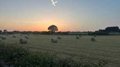
The land north of Dronfield Woodhouse is an important part of the character of the area. It is a valued green space which can be viewed from as far afield as Apperknowle and Hundall, and as close as Marsh Lane Play Area. It provides opportunities for walking, connecting with nature and enjoying the outdoors. The site contributes to the area's rural character and is used for various agricultural purposes and horse grazing, while supporting local wildlife, contributing to biodiversity, and enhancing the wellbeing of residents.
We ask North East Derbyshire District Council to reject the site — whether it comes forward through the Local Plan, a planning application, or both — on the material grounds set out below.
In a report by the CPRE, they identified significant brownfield sites across the country that can deliver the 1.5m target set out by the government:
Our concerns are:
1. Green Belt
The Council's 2016/17 Green Belt Review identified this site (parcel DRO/GB/078) as performing strongly against the purposes of preventing unrestricted sprawl and preventing neighbouring towns from merging. The current Local Plan process is subjecting the site to a new Green Belt Review following changes to national planning policy.
Any decision to release this land from the Green Belt should therefore be based on robust, up-to-date evidence and a clear justification for changing the previous assessment.
2. Highways and Road Safety
Any development on this site would significantly increase pressure on the surrounding road network. Residents are concerned about the impact on road safety, congestion and journey times, particularly around key routes and junctions including Carr Lane, Pentland Road, Bowshaw, Northern Common, Holmesfield, the Football Club junction and Wreakes Lane/Stubley Hollow.
These pressures would add to the existing challenges already experienced by residents travelling into, around, and out of Dronfield — on top of the cumulative impact of existing and planned commercial developments including Gunstones, Sainsbury's, Howdens, Screwfix, and the new Lidl on Wreakes Lane.
3. Infrastructure
Local schools are either operating at or, in some cases, above capacity. Roads, transport, and community facilities are, in some cases, already stretched.
A development of this scale would place additional pressure on infrastructure that is already under strain. Any decision to support further housing should be based on clear evidence that the necessary infrastructure can be provided alongside the development, rather than adding to existing pressures on local services and facilities.
4. Environment and Ecology
The site provides valuable habitat for local wildlife and contributes to biodiversity.
The site also sits within a historic coalfield. There are numerous examples nationally of geotechnical and ground structure issues taking place years after developing on land of this type. Coal mining risk assessments do not foresee every issue in advance.
Any development should therefore be supported by robust, site-specific assessments of ground conditions, stability, mining legacy risks, ecology and biodiversity before the site is considered suitable for development.
5. Planning
The site is not currently allocated for development. Its inclusion in the Local Plan, or any planning application, must be tested against robust, up-to-date evidence.
The emerging Local Plan process should not be used to establish the principle of development before the necessary evidence has demonstrated that this is an appropriate and sustainable location for housing.
6. Utilities, Drainage and Flood Risk
Residents already experience low water pressure locally, and have concerns that a development of this scale would place further strain on water supply and drainage capacity.
There are also numerous examples of surface-water flooding and waterlogging affecting gardens and properties adjacent to the proposed site, particularly following periods of significant rainfall. Residents have photographic and video evidence documenting these conditions. We believe the existing drainage and natural infiltration capacity of the area must be properly assessed before any development is considered.
Introducing a substantial number of new homes, roads, driveways and other hard surfaces could alter how rainfall is absorbed, stored and discharged across the site and surrounding area. This raises legitimate concerns about increased surface-water runoff and the potential for development to worsen existing flooding and drainage problems affecting neighbouring properties.
Any proposal should therefore be supported by robust, site-specific flood-risk, drainage and groundwater assessments demonstrating that development would not increase flood risk to existing homes or elsewhere in the catchment.
This petition provides an opportunity for residents across Dronfield to show they care about how our town grows - easing pressure on our roads and infrastructure, protecting our Green Belt, and ensuring local voices are heard as decisions are made, whether through the Local Plan process or a future planning application.
By signing this petition, you are asking North East Derbyshire District Council to:
- Protect the Green Belt around Dronfield.
- Remove Land North of Dronfield Woodhouse (Local Plan site 45160) from consideration for development within the Local Plan.
- Plan future housing growth in sustainable locations with the infrastructure needed to support existing and future communities.
- Ensure that any future proposals are supported by robust evidence on highways, infrastructure, ecology, ground conditions, drainage and flood risk.
We support sustainable development. We simply believe the land north of Dronfield Woodhouse is the wrong place for it, and that future housing should be delivered in locations that protect our Green Belt, support thriving communities, and provide the infrastructure needed for future generations.
To support us directly, you can donate at
https://pay.collctiv.com/dronfield-woodhouse-green-belt-25038
We are currently using donations to pay for our website and production of leaflets and posters.
https://www.dronfieldwoodhousegreenbelt.co.uk/
The right homes. The right places. Protect Dronfield Woodhouse.
1,634
The Issue
Please note - if you give money to change.org as part of signing the petition, it doesn't come directly to us, instead promotes the petition on change.org.
To support us directly - https://pay.collctiv.com/dronfield-woodhouse-green-belt-25038
When signing, please double check the postcode, as we have seen cases of a default postcode being used, and while all signatures are welcome, the most powerful are those in s18.
Thanks!
Protect Dronfield Woodhouse - Object to Land North of Dronfield Woodhouse Being Developed and Removed from the Green Belt
We, the undersigned, object to:
Any planning application submitted by Boningale Developments (or any successor developer) for residential development on Land North of Dronfield Woodhouse (Local Plan site reference 45160); and
The inclusion of Land North of Dronfield Woodhouse (site 45160) in North East Derbyshire District Council's emerging Local Plan.
We recognise that new homes are needed across North East Derbyshire. However, we believe they should be delivered in the right places, supported by the right infrastructure, and without the loss of a valued Green Belt.
Green Belt plays an important role in preventing urban sprawl, protecting the countryside from unnecessary development and preserving the character and identity of our communities. It provides space for nature, supports people's health and wellbeing through access to green space, and helps ensure neighbouring communities remain distinct. Once the Green Belt is lost to development, these benefits cannot simply be recreated elsewhere.
The land north of Dronfield Woodhouse is an important part of the character of the area. It is a valued green space which can be viewed from as far afield as Apperknowle and Hundall, and as close as Marsh Lane Play Area. It provides opportunities for walking, connecting with nature and enjoying the outdoors. The site contributes to the area's rural character and is used for various agricultural purposes and horse grazing, while supporting local wildlife, contributing to biodiversity, and enhancing the wellbeing of residents.
We ask North East Derbyshire District Council to reject the site — whether it comes forward through the Local Plan, a planning application, or both — on the material grounds set out below.
In a report by the CPRE, they identified significant brownfield sites across the country that can deliver the 1.5m target set out by the government:
Our concerns are:
1. Green Belt
The Council's 2016/17 Green Belt Review identified this site (parcel DRO/GB/078) as performing strongly against the purposes of preventing unrestricted sprawl and preventing neighbouring towns from merging. The current Local Plan process is subjecting the site to a new Green Belt Review following changes to national planning policy.
Any decision to release this land from the Green Belt should therefore be based on robust, up-to-date evidence and a clear justification for changing the previous assessment.
2. Highways and Road Safety
Any development on this site would significantly increase pressure on the surrounding road network. Residents are concerned about the impact on road safety, congestion and journey times, particularly around key routes and junctions including Carr Lane, Pentland Road, Bowshaw, Northern Common, Holmesfield, the Football Club junction and Wreakes Lane/Stubley Hollow.
These pressures would add to the existing challenges already experienced by residents travelling into, around, and out of Dronfield — on top of the cumulative impact of existing and planned commercial developments including Gunstones, Sainsbury's, Howdens, Screwfix, and the new Lidl on Wreakes Lane.
3. Infrastructure
Local schools are either operating at or, in some cases, above capacity. Roads, transport, and community facilities are, in some cases, already stretched.
A development of this scale would place additional pressure on infrastructure that is already under strain. Any decision to support further housing should be based on clear evidence that the necessary infrastructure can be provided alongside the development, rather than adding to existing pressures on local services and facilities.
4. Environment and Ecology
The site provides valuable habitat for local wildlife and contributes to biodiversity.
The site also sits within a historic coalfield. There are numerous examples nationally of geotechnical and ground structure issues taking place years after developing on land of this type. Coal mining risk assessments do not foresee every issue in advance.
Any development should therefore be supported by robust, site-specific assessments of ground conditions, stability, mining legacy risks, ecology and biodiversity before the site is considered suitable for development.
5. Planning
The site is not currently allocated for development. Its inclusion in the Local Plan, or any planning application, must be tested against robust, up-to-date evidence.
The emerging Local Plan process should not be used to establish the principle of development before the necessary evidence has demonstrated that this is an appropriate and sustainable location for housing.
6. Utilities, Drainage and Flood Risk
Residents already experience low water pressure locally, and have concerns that a development of this scale would place further strain on water supply and drainage capacity.
There are also numerous examples of surface-water flooding and waterlogging affecting gardens and properties adjacent to the proposed site, particularly following periods of significant rainfall. Residents have photographic and video evidence documenting these conditions. We believe the existing drainage and natural infiltration capacity of the area must be properly assessed before any development is considered.
Introducing a substantial number of new homes, roads, driveways and other hard surfaces could alter how rainfall is absorbed, stored and discharged across the site and surrounding area. This raises legitimate concerns about increased surface-water runoff and the potential for development to worsen existing flooding and drainage problems affecting neighbouring properties.
Any proposal should therefore be supported by robust, site-specific flood-risk, drainage and groundwater assessments demonstrating that development would not increase flood risk to existing homes or elsewhere in the catchment.
This petition provides an opportunity for residents across Dronfield to show they care about how our town grows - easing pressure on our roads and infrastructure, protecting our Green Belt, and ensuring local voices are heard as decisions are made, whether through the Local Plan process or a future planning application.
By signing this petition, you are asking North East Derbyshire District Council to:
- Protect the Green Belt around Dronfield.
- Remove Land North of Dronfield Woodhouse (Local Plan site 45160) from consideration for development within the Local Plan.
- Plan future housing growth in sustainable locations with the infrastructure needed to support existing and future communities.
- Ensure that any future proposals are supported by robust evidence on highways, infrastructure, ecology, ground conditions, drainage and flood risk.
We support sustainable development. We simply believe the land north of Dronfield Woodhouse is the wrong place for it, and that future housing should be delivered in locations that protect our Green Belt, support thriving communities, and provide the infrastructure needed for future generations.
To support us directly, you can donate at
https://pay.collctiv.com/dronfield-woodhouse-green-belt-25038
We are currently using donations to pay for our website and production of leaflets and posters.
https://www.dronfieldwoodhousegreenbelt.co.uk/
The right homes. The right places. Protect Dronfield Woodhouse.
The Decision Makers

Supporter Voices
Petition Updates
Share this petition
Petition created on August 9, 2026