

Objection to the Declaration of a Road as a Public Road in Kiltullagh
The Issue
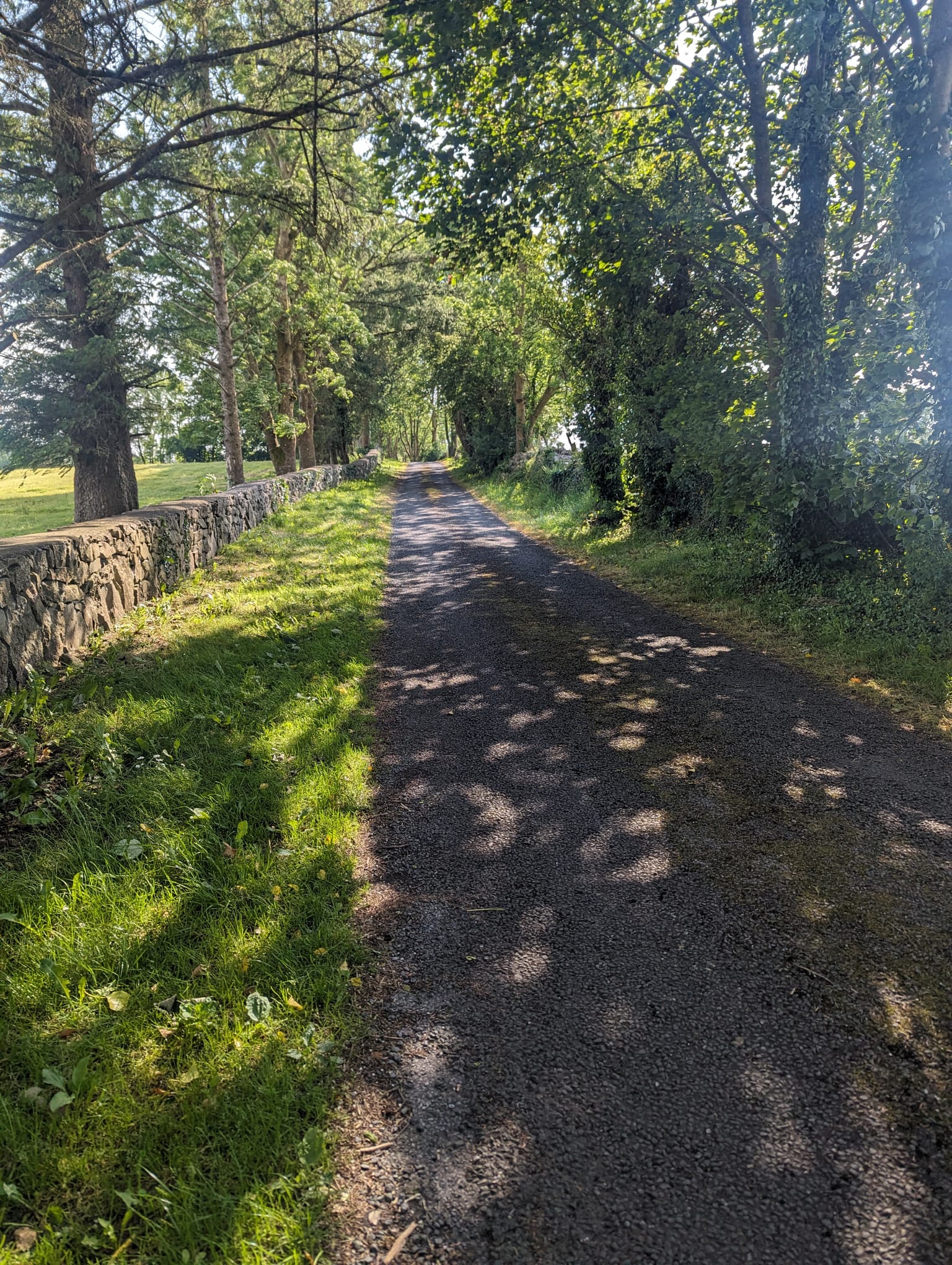
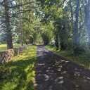
The road is historically significant as the last intact section of the old Dublin to Galway Road, documented in 1777 with walls untouched since the famine, it was part of the ancient "Road of the Kings." It is surrounded by built heritage, including Kiltullagh House, the Coffin Rest, and the Smithy, each contributing to the area's rich historical narrative. The road also serves as a critical natural habitat and recreational amenity, fostering biodiversity with its diverse tree canopy, hedgerows, and verges, while providing a serene environment for walking and cycling, which would be compromised by proposed upgrades.
For indepth details on objections;
Historical Significance:
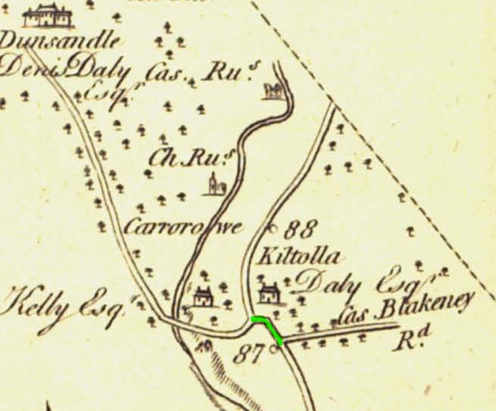
· The road is of local and national importance as it is the only remaining intact section of the old Dublin to Galway Road, as documented in Taylor and Skinner’s Maps of the Roads of Ireland surveyed in 1777 and commissioned by the Houses of Commons in Ireland. It remains virtually intact except for some maintenance by local farmers, with the north side of this road untouched since famine times. [George Taylor & Andrew Skinner (1778) Taylor and Skinner’s Maps of the Roads of Ireland, London].
· The road is also part of the 'Rot na Ri' (or Road of the Kings) ancient route, referred to in the poem 'Magh Fot ar Rot na Ri' and in oral local history. [O'Connor, Fr T., Jordan, K. ed. (2003) Turoe & Athenry: Ancient Capitals of Celtic Ireland, Middleton, Tom O'Connor.].
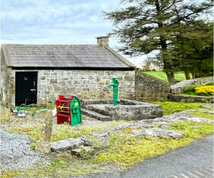
· It is bookended by a Coffin Rest at the western side and a Smithy (known locally today as ‘The Forge’) on the Eastern side which was set up 75 metres west of the entrance to the Cornmill.
· Ireland was the first country in the world to be fully surveyed, [Conor Graham, Ireland’s Surveying Heritage – past, present and future. Centre for GIS and Geomatics, Queen's University Belfast, 2015] and one of the primary trigonometrical stations of the 1834 landmark survey is located by this road and listed on the 6-inch historical maps.
· The benchmarks from that survey (1834) on the 6-inch historical maps are still visible today - on the stone wall along the road and at the Smithy/The Forge - based on this, the assumption is that they are the original structures from at least pre-famine times.
· It's worth noting that a section of the existing R348, stretching from the triangle in the heart of the village up to the Smithy/The Forge , is absent from the 1838 map (C. Galway - Sheet 97. Surveyed: 1838, Printed: 1841). Local history is intertwined with the construction of this road in the 1840s, initiated by Lord Dunsandle to avoid passing by the parish priest's house and travelling the only direct road at the time from Dunsandle House, the L-71822, towards the L-3115 (the road we are seeking to preserve), leading to Attymon House. Here, the hunting lodge served as a retreat for the young beau and was where he settled Mary Broderick (1823-1868), a young farmer's daughter from the neighbouring townland of Carnakelly, whom he eventually married, and they had children together.
Built Heritage:
· Kiltullagh House: Keeping in mind what was mentioned above that this road was the main Dublin to Galway Road (Taylor and Skinner, 1778), the road is connected to the history and heritage of the locality, to Galway’s history, and nationally and internationally. The D'Arcy family, one of the Tribes of Galway, lived 375 metres from this road, in Kiltullagh House. Patrick D'Arcy (1598–1668) was a Councillor-at-Law (and wrote the constitution of Confederate Ireland) and a member of the House of Commons in Dublin. His father, James 'Riveagh' D'Arcy, was Mayor of Galway in 1602/3. Following the Irish Rebellion of 1641, Patrick was said to have raised an army of 10,000 men to fight Cromwell. Kiltullagh House was also the birthplace of the distinguished mathematician and philosopher, Count Patrick d'Arcy (1725-1779). Fourteen-year-old Patrick was reportedly smuggled onto one of his uncle's ships during the Penal Law period, as the D’Arcy’s were Catholics and Jacobite supporters. The ship sailed from Galway to France, where he was educated and lived in Paris. Additionally, John D'Arcy (1785–1839), High Sheriff of the county in 1811, inherited the Kiltullagh estate in 1812 and was the last resident at Kiltullagh House. At the time, this road was the main road used by the Darcy family. Following the death of his wife, Francis Blake, he left Kiltullagh and took up residence in his castle in Clifden; thereafter, he founded the town of Clifden (often referred to as 'the Capital of Connemara'). John D'Arcy got into financial difficulty, which led to Pierse Joyce purchasing the Kiltullagh estate in 1850 under the Commissioners for the Sale of Encumbered Estates in Ireland. The house itself was one of the first slated houses in this part of the country. However, by the time Joyce purchased it, it had been idle, having been destroyed by fire some years earlier. According to Vanishing Country Houses of Ireland (1988), ‘The very high chimney-stacks have sunk panels, and there are pistol-loops in the basement, which is most unusual for a house of this period. The house, which is now a ruin, is a most impressive example of an early virtually undefended house and should be preserved from further depredation.’ Built c. 1725, Kiltullagh House is a five-bay two-storey over half-basement house.
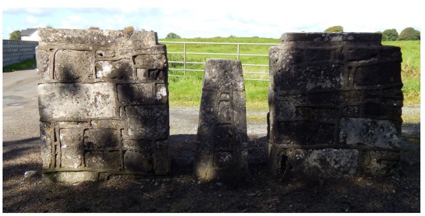
· Coffin rest: A coffin rest, or coffin stone, is a rare but enduring piece of Irish burial tradition, used in the eighteenth and nineteenth centuries as a resting place during the funeral procession from the church to the graveyard. Although this tradition is no longer observed in Kiltullagh, it was once customary for mourners to carry coffins on their shoulders to Kiltullagh graveyard. They would pause at the stone stile, resting the coffin on the middle pier and passing through one of the two openings before continuing down the road to the cemetery. The coffin rest is positioned in the middle of a crossroads on the L-71822 Kiltullagh cemetery road. The custom of resting the coffin on a specific stone and engaging in prayer, wailing, or dancing was observed in some parts of Ireland, and while it is unknown, it is possible that some or all these traditions were practiced at this coffin rest.
· Kiltullagh Graveyard: Kiltullagh graveyard is nestled between the Coffin Rest and Kiltullagh House, with the oldest headstone dating back to 1714. The side wall of the medieval church offers insight into the rich history of this sacred location.
· Smithy/The Forge: Nestled at the crossroads where the L-71822 road meets the L-3115, towards the R-348 to Dublin, it’s believed that forges were strategically placed at such locations for the convenience of travellers. Serving as a poignant symbol of Kiltullagh’s rural heritage, the forge stands as a testament to the bygone era of country living. The forge was probably a hive of activity, where skilled blacksmiths expertly shoed horses and donkeys, repaired gates and agricultural tools, and maintained cartwheels.
· Kiltullagh Post Office: The post office featured on the historical 6-inch map is 130 metres from the road. It is still standing today and has been a thatched public house since 1871. [Jordan, K. ed. Kiltullagh Killimordaly, As the Centuries passed A History from 1500-1900, 2000, Midleton.]
Any modifications to this unique historical road that widen it or damage its walls would destroy verifiable connections to our past and is the glue that ties it all together. Furthermore, considering the road's potential to be part of a historical trail or one that includes both our natural and built heritage, such as Galway County Council's and Galway Rural Development’s Golden Mile of Galway, underscores the importance of its preservation.
Amenity Impact
The road serves as a vital component of a local walking circuit, cherished by both residents of Kiltullagh Killimordaly and visitors. Its narrow width, at times just 2 metres, coupled with the availability of an alternative public road, naturally calms traffic, fostering a safe and serene environment for walking, running, and cycling. This pathway enables engagement with the area's rich natural and historical heritage and stands as a distinctive communal asset. Preserving its condition is essential for sustaining the quality of life for both current and future generations. The proposed upgrades, aimed at widening the road, pose a significant risk by potentially increasing both traffic flow and speed, subsequently undermining the road's tranquillity and safety for pedestrians and cyclists.
Natural Heritage:
The road is a haven for wildlife, featuring a mix of different habitat types along the road, including:
● Trees: The area is home to a lush canopy of over 100 trees, encompassing species such as sycamore, copper beech, hawthorn, elder, ash, spruce, rowan, elm, holly, Macrocarpa, and horse chestnut. This diverse collection not only elevates the area's aesthetic but also forms the backbone of a vibrant ecosystem, providing shelter and sustenance for birds (including rooks, magpies, and songbirds) as well as bats, thereby enriching biodiversity. Road expansion would necessitate the removal of these trees, devastating their ecosystems.
● The ivy-clad walls are crucial for a multitude of species, offering food and shelter to insects, mice, shrews, hedgehogs, hares, and various bird species. They underscore the road's role in sustaining local fauna.
● Hedgerows: Rich in biodiversity, these hedgerows are especially vital during the nesting period, contributing significantly to the area's ecological integrity.
● Verges: A paradise for foragers, the verges are teeming with native flora, including dandelions, primroses, daisies, buttercups, clover, and bluebells. These plants are a rich nectar source for crucial pollinators like bees and beetles, playing an essential role in maintaining the road's biodiversity.
The proposed widening of the road, which is likely to increase traffic, threatens the thriving biodiversity that currently exists, affecting the delicate natural balance that supports a wide range of wildlife.
Petition Closed
The Issue
The road is historically significant as the last intact section of the old Dublin to Galway Road, documented in 1777 with walls untouched since the famine, it was part of the ancient "Road of the Kings." It is surrounded by built heritage, including Kiltullagh House, the Coffin Rest, and the Smithy, each contributing to the area's rich historical narrative. The road also serves as a critical natural habitat and recreational amenity, fostering biodiversity with its diverse tree canopy, hedgerows, and verges, while providing a serene environment for walking and cycling, which would be compromised by proposed upgrades.
For indepth details on objections;
Historical Significance:
· The road is of local and national importance as it is the only remaining intact section of the old Dublin to Galway Road, as documented in Taylor and Skinner’s Maps of the Roads of Ireland surveyed in 1777 and commissioned by the Houses of Commons in Ireland. It remains virtually intact except for some maintenance by local farmers, with the north side of this road untouched since famine times. [George Taylor & Andrew Skinner (1778) Taylor and Skinner’s Maps of the Roads of Ireland, London].
· The road is also part of the 'Rot na Ri' (or Road of the Kings) ancient route, referred to in the poem 'Magh Fot ar Rot na Ri' and in oral local history. [O'Connor, Fr T., Jordan, K. ed. (2003) Turoe & Athenry: Ancient Capitals of Celtic Ireland, Middleton, Tom O'Connor.].
· It is bookended by a Coffin Rest at the western side and a Smithy (known locally today as ‘The Forge’) on the Eastern side which was set up 75 metres west of the entrance to the Cornmill.
· Ireland was the first country in the world to be fully surveyed, [Conor Graham, Ireland’s Surveying Heritage – past, present and future. Centre for GIS and Geomatics, Queen's University Belfast, 2015] and one of the primary trigonometrical stations of the 1834 landmark survey is located by this road and listed on the 6-inch historical maps.
· The benchmarks from that survey (1834) on the 6-inch historical maps are still visible today - on the stone wall along the road and at the Smithy/The Forge - based on this, the assumption is that they are the original structures from at least pre-famine times.
· It's worth noting that a section of the existing R348, stretching from the triangle in the heart of the village up to the Smithy/The Forge , is absent from the 1838 map (C. Galway - Sheet 97. Surveyed: 1838, Printed: 1841). Local history is intertwined with the construction of this road in the 1840s, initiated by Lord Dunsandle to avoid passing by the parish priest's house and travelling the only direct road at the time from Dunsandle House, the L-71822, towards the L-3115 (the road we are seeking to preserve), leading to Attymon House. Here, the hunting lodge served as a retreat for the young beau and was where he settled Mary Broderick (1823-1868), a young farmer's daughter from the neighbouring townland of Carnakelly, whom he eventually married, and they had children together.
Built Heritage:
· Kiltullagh House: Keeping in mind what was mentioned above that this road was the main Dublin to Galway Road (Taylor and Skinner, 1778), the road is connected to the history and heritage of the locality, to Galway’s history, and nationally and internationally. The D'Arcy family, one of the Tribes of Galway, lived 375 metres from this road, in Kiltullagh House. Patrick D'Arcy (1598–1668) was a Councillor-at-Law (and wrote the constitution of Confederate Ireland) and a member of the House of Commons in Dublin. His father, James 'Riveagh' D'Arcy, was Mayor of Galway in 1602/3. Following the Irish Rebellion of 1641, Patrick was said to have raised an army of 10,000 men to fight Cromwell. Kiltullagh House was also the birthplace of the distinguished mathematician and philosopher, Count Patrick d'Arcy (1725-1779). Fourteen-year-old Patrick was reportedly smuggled onto one of his uncle's ships during the Penal Law period, as the D’Arcy’s were Catholics and Jacobite supporters. The ship sailed from Galway to France, where he was educated and lived in Paris. Additionally, John D'Arcy (1785–1839), High Sheriff of the county in 1811, inherited the Kiltullagh estate in 1812 and was the last resident at Kiltullagh House. At the time, this road was the main road used by the Darcy family. Following the death of his wife, Francis Blake, he left Kiltullagh and took up residence in his castle in Clifden; thereafter, he founded the town of Clifden (often referred to as 'the Capital of Connemara'). John D'Arcy got into financial difficulty, which led to Pierse Joyce purchasing the Kiltullagh estate in 1850 under the Commissioners for the Sale of Encumbered Estates in Ireland. The house itself was one of the first slated houses in this part of the country. However, by the time Joyce purchased it, it had been idle, having been destroyed by fire some years earlier. According to Vanishing Country Houses of Ireland (1988), ‘The very high chimney-stacks have sunk panels, and there are pistol-loops in the basement, which is most unusual for a house of this period. The house, which is now a ruin, is a most impressive example of an early virtually undefended house and should be preserved from further depredation.’ Built c. 1725, Kiltullagh House is a five-bay two-storey over half-basement house.
· Coffin rest: A coffin rest, or coffin stone, is a rare but enduring piece of Irish burial tradition, used in the eighteenth and nineteenth centuries as a resting place during the funeral procession from the church to the graveyard. Although this tradition is no longer observed in Kiltullagh, it was once customary for mourners to carry coffins on their shoulders to Kiltullagh graveyard. They would pause at the stone stile, resting the coffin on the middle pier and passing through one of the two openings before continuing down the road to the cemetery. The coffin rest is positioned in the middle of a crossroads on the L-71822 Kiltullagh cemetery road. The custom of resting the coffin on a specific stone and engaging in prayer, wailing, or dancing was observed in some parts of Ireland, and while it is unknown, it is possible that some or all these traditions were practiced at this coffin rest.
· Kiltullagh Graveyard: Kiltullagh graveyard is nestled between the Coffin Rest and Kiltullagh House, with the oldest headstone dating back to 1714. The side wall of the medieval church offers insight into the rich history of this sacred location.
· Smithy/The Forge: Nestled at the crossroads where the L-71822 road meets the L-3115, towards the R-348 to Dublin, it’s believed that forges were strategically placed at such locations for the convenience of travellers. Serving as a poignant symbol of Kiltullagh’s rural heritage, the forge stands as a testament to the bygone era of country living. The forge was probably a hive of activity, where skilled blacksmiths expertly shoed horses and donkeys, repaired gates and agricultural tools, and maintained cartwheels.
· Kiltullagh Post Office: The post office featured on the historical 6-inch map is 130 metres from the road. It is still standing today and has been a thatched public house since 1871. [Jordan, K. ed. Kiltullagh Killimordaly, As the Centuries passed A History from 1500-1900, 2000, Midleton.]
Any modifications to this unique historical road that widen it or damage its walls would destroy verifiable connections to our past and is the glue that ties it all together. Furthermore, considering the road's potential to be part of a historical trail or one that includes both our natural and built heritage, such as Galway County Council's and Galway Rural Development’s Golden Mile of Galway, underscores the importance of its preservation.
Amenity Impact
The road serves as a vital component of a local walking circuit, cherished by both residents of Kiltullagh Killimordaly and visitors. Its narrow width, at times just 2 metres, coupled with the availability of an alternative public road, naturally calms traffic, fostering a safe and serene environment for walking, running, and cycling. This pathway enables engagement with the area's rich natural and historical heritage and stands as a distinctive communal asset. Preserving its condition is essential for sustaining the quality of life for both current and future generations. The proposed upgrades, aimed at widening the road, pose a significant risk by potentially increasing both traffic flow and speed, subsequently undermining the road's tranquillity and safety for pedestrians and cyclists.
Natural Heritage:
The road is a haven for wildlife, featuring a mix of different habitat types along the road, including:
● Trees: The area is home to a lush canopy of over 100 trees, encompassing species such as sycamore, copper beech, hawthorn, elder, ash, spruce, rowan, elm, holly, Macrocarpa, and horse chestnut. This diverse collection not only elevates the area's aesthetic but also forms the backbone of a vibrant ecosystem, providing shelter and sustenance for birds (including rooks, magpies, and songbirds) as well as bats, thereby enriching biodiversity. Road expansion would necessitate the removal of these trees, devastating their ecosystems.
● The ivy-clad walls are crucial for a multitude of species, offering food and shelter to insects, mice, shrews, hedgehogs, hares, and various bird species. They underscore the road's role in sustaining local fauna.
● Hedgerows: Rich in biodiversity, these hedgerows are especially vital during the nesting period, contributing significantly to the area's ecological integrity.
● Verges: A paradise for foragers, the verges are teeming with native flora, including dandelions, primroses, daisies, buttercups, clover, and bluebells. These plants are a rich nectar source for crucial pollinators like bees and beetles, playing an essential role in maintaining the road's biodiversity.
The proposed widening of the road, which is likely to increase traffic, threatens the thriving biodiversity that currently exists, affecting the delicate natural balance that supports a wide range of wildlife.
Petition Updates
Share this petition
Petition created on 10 June 2024