
Join Public Comment on EIR for Proposed Development of 132 units on Marshall Ln Saratoga
The Issue
Comments on the Draft Environmental Impact Report
18500 & 18520 Marshall Lane Townhome Project
City of Saratoga, California
State Clearinghouse No. 2025100481
To: City of Saratoga Community Development Department; Cindy McCormick / Kavitha Kumar, Contract Planner
Subject: 18500 and 18520 Marshall Lane Townhome Project - Draft EIR Comments
Purpose and scope of these comments
These comments focus on the Draft EIR's own findings concerning emergency response and evacuation, wildfire evacuation, transportation and vehicle miles traveled (VMT), the relationship between project density and those impacts, the alternatives analysis, the Marshall Lane Elementary School setting, and the distinction between on-site emergency access and off-site evacuation capacity. The comments do not ask the City to reach a predetermined approval or denial decision. They request disclosure, clarification, quantification, and reasoned responses sufficient for decision-makers and the public to understand the magnitude of the impacts and the extent to which feasible alternatives or mitigation could lessen them.
The Draft EIR evaluates a 132-unit, three-story townhome project on approximately 9.84 acres. It identifies significant and unavoidable project-level and cumulative impacts involving emergency response/evacuation, wildfire evacuation, and VMT.
Executive summary of principal issues requiring response
Project-specific evacuation effect is not clearly quantified. The EIR concludes that the 132-unit project will contribute to evacuation delay and that its impact is significant and unavoidable, but the quantitative evacuation results presented in the EIR rely heavily on a development projection containing 725 pending subdivision units. The Final EIR should additionally disclose the incremental evacuation effect of the 132-unit project itself.
Quito Road is an identified bottleneck near the project. The EIR states that Saratoga's evacuation network is already constrained and that Quito Road near the project is among the localized bottlenecks. Because project residents ultimately depend on this network, the magnitude of project-related queueing and delay at the controlling bottlenecks should be disclosed.
Mitigation does not address the physical capacity problem. MM HAZ-4 emphasizes education, preparedness, route familiarity, notification and a site-specific evacuation plan. The EIR itself acknowledges that these measures do not eliminate the project's increase in evacuation delay. The record should identify physical or demand-reduction measures considered and explain why additional measures are or are not feasible.
Large analytical gap between 22 and 132 units. The EIR analyzes a 22-unit Maximum Density Bonus Alternative and the 132-unit proposal, but no intermediate-density alternative. Because the EIR recognizes that fewer residents and trips reduce evacuation effects and most other impacts, the City should explain whether an intermediate-density alternative could substantially lessen significant effects while still providing substantial housing, including affordable housing.
School-related evacuation assumptions are unclear. Marshall Lane Elementary is immediately adjacent to the project area and Marshall Lane serves school access. The EIR discusses Safe Routes to School improvements, but the Draft EIR does not clearly disclose whether the evacuation model represents school arrival/dismissal, students, staff, buses, parent pickup traffic, or parents traveling toward the school during an emergency.
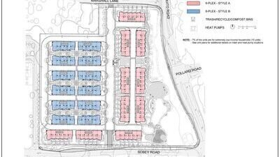
Sobey Road EVA assumptions require clarification. Normal site access is from a 24-foot driveway on Marshall Lane, while Sobey Road is identified as an Emergency Vehicle Access (EVA). The Final EIR should state whether residents may use the Sobey connection during an evacuation and how that assumption is represented in evacuation modeling noting that both Marshall Lane and Sobey Road feed Quito Road.
General Plan Safety Element consistency requires reconciliation. The land-use analysis finds consistency with Safety Element Policy SAF-4.23, while the hazards/wildfire analysis finds that the project adds traffic to an already constrained evacuation network and causes significant and unavoidable evacuation effects. The Final EIR should reconcile those conclusions.
High VMT remains after maximum identified mitigation. The project site's modeled VMT is well above the City's threshold. Even after the identified VMT reductions, the EIR reports 14.58 VMT per capita compared with an 11.33 threshold. This supports a need for transparent discussion of the transportation consequences of placing 132 units at this location.
1. Emergency evacuation conditions are already constrained
The Draft EIR reports that the City's May 2026 Wildfire Evacuation Time Estimates (ETE) work shows lengthy baseline evacuation times. For the total evacuating population, approximately 90 percent evacuation is estimated at about 2 hours 45 minutes and 100 percent evacuation at about 5 hours. For residents alone, the corresponding figures are approximately 2 hours 15 minutes and 3 hours 45 minutes. Under the development projection containing 725 pending subdivision units, including this project, the EIR reports increases of less than 15 minutes for the total population at the 90- and 100-percent levels, while resident-only evacuation increases by approximately 15 minutes at 90 percent and 30 minutes at 100 percent. Under a broader cumulative development projection, the EIR reports an approximately 30-minute increase in total-population 90-percent ETE and an approximately 1-hour 15-minute increase in total-population 100-percent ETE.
The Draft EIR further states that the 2025 Evacuation Route Capacity Assessment identified locations where roadway demand exceeded available capacity, and that the 2026 ETE analysis reflects those constraints at the system level. It specifically identifies Quito Road near the proposed project as a localized bottleneck.
Requested response: Please disclose the baseline and future modeled demand/capacity, queue lengths, delay, and evacuation times at Quito Road and any other controlling bottlenecks serving the project. Identify the roadway links/intersections that control evacuation performance for the project vicinity.
2. Quantify the 132-unit project's standalone evacuation contribution
The EIR makes a project-level finding that the proposed project would impair or physically interfere with an adopted emergency response or evacuation plan and that the effect remains significant and unavoidable after mitigation. It also concludes that the project's incremental contribution to cumulative evacuation impacts is significant because it adds traffic to an already constrained network.
However, the quantitative ETE results summarized in the Draft EIR appear to place the project within a 725-unit future-development projection without also reporting the 132-unit project's incremental effect. Without a project-only run, the public cannot readily determine how much of the modeled delay is attributable to this project as opposed to the other future units.
Requested response: Provide an ETE scenario consisting of existing conditions plus the 132-unit Marshall Lane project alone. Report, at minimum, changes in 50-percent, 90-percent and 100-percent evacuation time; queue length; delay; volume/capacity or comparable saturation metrics; and the project's contribution at Quito Road and other controlling bottlenecks. If the existing ETE model cannot produce a project-only scenario, explain why and identify the evidence supporting the project-level significance conclusion.
3. Evaluate the relationship between project density and evacuation impact
The EIR recognizes that alternatives with fewer units would contain fewer residents and generate less traffic, and therefore would reduce evacuation traffic relative to the 132-unit proposal, even though the EIR concludes that the already constrained network causes the evacuation significance determination to remain. This establishes that the magnitude of the environmental effect varies with development intensity.
The alternatives analysis, however, moves from the 22-unit Maximum Density Bonus Alternative directly to the 132-unit proposal. The Draft EIR does not disclose an intermediate-density scenario specifically designed to substantially lessen the significant evacuation effect while still providing a substantial number of homes.
Requested response: Explain why no intermediate-density alternative between 22 and 132 units was evaluated for the purpose of substantially lessening the significant evacuation effect. Consider sensitivity testing at representative intermediate intensities and disclose how evacuation performance changes as unit count and evacuating population change. The purpose of this request is not to prescribe a particular unit count, but to make the density-impact relationship transparent.
4. MM HAZ-4 does not eliminate the physical evacuation delay
MM HAZ-4 includes community evacuation education, preparedness and route-familiarity measures, advance preparation and notification systems, awareness programs, and a site-specific evacuation plan. The Draft EIR expressly acknowledges that these measures would not eliminate the project's increase in evacuation delay and would not reduce the effect to less than significant.
Requested response: Identify the physical capacity, operational, access-management, evacuation-phasing, or demand-reduction measures that were considered in addition to education and notification. For each measure not adopted, explain whether it was rejected for infeasibility, limited effectiveness, secondary environmental effects, legal constraints, or another reason. Include reduced development intensity among the measures or alternatives discussed if it was considered as a means of reducing evacuation demand.
5. Clarify how the Sobey Road Emergency Vehicle Access functions during evacuation
The project description identifies a 24-foot-wide driveway from Marshall Lane as the normal site access and an Emergency Vehicle Access (EVA) from Sobey Road. The EIR's evacuation discussion states that project residents would evacuate onto Marshall Lane and then toward Quito Road. The operational role of the Sobey EVA for resident egress during an evacuation is therefore important.
Requested response: State whether residents will be permitted or directed to exit through the Sobey Road EVA during an evacuation. If yes, describe how and when the connection is opened, who controls it, whether it is reliably available without manual intervention, what share of resident evacuation traffic the model assigns to it, and how traffic is routed after reaching Sobey Road. If no, state clearly that the 132-unit development relies on the Marshall Lane driveway for resident evacuation and explain how that condition is represented in the ETE analysis.
6. Distinguish emergency apparatus access from community evacuation capacity
The Draft EIR states that Santa Clara County Fire reviewed the project and imposed conditions concerning hydrants, emergency access, water supply, fire flow and sprinklers. Internal roads are described as 24 feet wide with a 50-foot turning radius, and the land-use discussion references fire lanes and aerial apparatus access. These features address the ability of emergency equipment to access the site.
They do not, by themselves, demonstrate that the surrounding public roadway network can evacuate the additional population without worsening delay. The EIR itself reaches a significant-and-unavoidable conclusion for regional evacuation despite the fire-access features.
Requested response: In the Final EIR, distinguish clearly between compliance with fire-code/emergency-apparatus access requirements and the separate CEQA finding concerning off-site evacuation capacity. Identify any SCCFD conclusion that specifically addresses regional civilian evacuation capacity, as opposed to on-site fire access.
7. Reconcile General Plan Safety Element Policy SAF-4.23 with the evacuation findings
The EIR quotes Safety Element Policy SAF-4.23 as seeking to ensure that existing development in areas with sufficient supply infrastructure and roadway capacity to maintain adequate evacuation and emergency equipment access does not degrade as a result of new development. The land-use analysis finds the project consistent, stating that increased vehicle, bicycle and pedestrian demand would not substantially affect emergency vehicle access patterns.
Elsewhere, however, the EIR concludes that the City's evacuation roadway network is already constrained, that Quito Road near the project is a bottleneck, that the project adds traffic to that constrained system, and that the resulting project-level and cumulative evacuation impacts are significant and unavoidable.
Requested response: Reconcile the SAF-4.23 consistency determination with the significant-and-unavoidable evacuation findings. Explain whether the policy addresses only emergency-vehicle access patterns or also civilian evacuation capacity, and identify the quantitative or other evidence supporting the consistency conclusion.
8. Marshall Lane Elementary School conditions should be explicit in the evacuation analysis
Marshall Lane Elementary School is immediately adjacent to the project vicinity, and Marshall Lane provides school access. The Draft EIR acknowledges public requests for analysis of school pedestrian safety and emergency evacuation routes. It also identifies Safe Routes to School improvements, including sidewalk completion, crosswalks, lighting, bicycle facilities, ADA upgrades and intersection improvements.
Those improvements address ordinary pedestrian and bicycle conditions. The Draft EIR does not clearly disclose whether the ETE model represents a weekday emergency during school arrival or dismissal, when school traffic and the behavior of parents attempting to reach children could differ materially from ordinary conditions.
Requested response: Identify the school-related assumptions in the ETE model, including Marshall Lane Elementary enrollment/population, staff, buses, vehicles already on site, parent pickup/drop-off traffic, school release/evacuation procedures, and whether parents traveling toward the school after an emergency notification are represented. State the modeled time-of-day and whether school arrival/dismissal conditions were tested. If not, explain why those conditions would not materially affect the conclusions.
9. Ordinary sight-distance findings do not establish evacuation adequacy
Fehr & Peers performed a sight-distance analysis at the proposed Marshall Lane driveway and concluded that visibility and stopping distance are adequate for a 25 mph design speed, subject to maintaining/removing trees that obstruct sight lines. That analysis supports ordinary driveway maneuverability.
It does not answer whether the driveway and downstream Marshall Lane/Quito Road network can accommodate a simultaneous evacuation of the project's residents during a regional emergency.
Requested response: Confirm that the sight-distance analysis is not being relied upon as evidence that evacuation capacity is adequate. Provide the separate capacity/queueing evidence used to evaluate evacuation operations at the driveway and downstream network.
10. Transportation trip generation should be tied directly to evacuation assumptions
The Draft EIR reports approximately 864 net new daily vehicle trips, 59 AM peak-hour trips, and 71 PM peak-hour trips from the proposed project. Because the project is below 100 peak-hour trips, the EIR notes that a VTA Congestion Management Program analysis is not required. That threshold concerns conventional transportation analysis and does not resolve the separate evacuation impact.
Requested response: Identify the household size, vehicles-per-household, vehicle occupancy, evacuation participation rate, departure curve, route choice, and destination assumptions used to translate 132 dwelling units into evacuation demand. Explain how those assumptions relate to, or differ from, the ordinary trip-generation assumptions in Appendix I.
11. VMT remains substantially above the City's threshold after mitigation
The EIR reports existing project-area VMT of 18.22 per capita and project conditions of 17.61 VMT per capita, compared with a significance threshold of 11.33. With bicycle/pedestrian improvements the EIR reports 15.49, and with the maximum allowable identified reductions it reports 14.58. Thus, even after the identified mitigation, the modeled VMT remains materially above the City's threshold and the impact remains significant and unavoidable.
Reduced density should not be assumed automatically to reduce per-capita VMT; the EIR indicates that some lower-density alternatives could have equal or greater VMT per resident. Nevertheless, development intensity changes total population and total travel demand and is relevant to the broader transportation and evacuation analysis.
Requested response: Disclose the calculation and effectiveness assigned to each VMT-reduction measure, identify which reductions are capped by City methodology, and explain whether any additional feasible transportation-demand-management measures were considered. Distinguish per-capita VMT from total project travel when discussing alternatives.
12. The alternatives analysis should explain the missing intermediate-density alternative
The Draft EIR analyzes the No Project Alternative, the approved nine-lot subdivision alternative, and a 22-unit Maximum Density Bonus Alternative. It identifies the approved nine-lot subdivision as the environmentally superior development alternative because it reduces most impacts, while also explaining that it would not provide the extremely-low-income housing objective of the proposed project. The 22-unit alternative retains affordable units and reduces most environmental impacts relative to the proposed project, but contributes less toward the project's housing objectives.
Chapter 6 also identifies alternatives rejected from detailed consideration: an alternative site layout, alternative lot sizes, a primary entry point from Pollard Road, and an alternative site. The rejected-alternatives discussion does not appear to identify an intermediate-density alternative between 22 and 132 units.
Requested response: Explain whether an intermediate-density alternative was considered during scoping or EIR preparation. If it was, identify the unit count/configuration and the reason it was rejected. If it was not, explain why the range of alternatives is considered sufficient despite the significant-and-unavoidable evacuation impact and the acknowledged reduction in evacuation traffic associated with fewer units.
13. Project objectives should not obscure the environmental tradeoff
One project objective is to 'maximize development of medium-density housing' while assisting the City in meeting housing needs, including extremely-low-income and above-moderate-income housing. Other objectives include providing housing for a diversity of income levels and developing an underutilized infill site already designated for residential use.
Because 'maximize' is itself an intensity-oriented objective, the Final EIR should make transparent how that objective affected the range of alternatives considered. An alternative can reduce density while still potentially advance the broader purposes of providing market-rate and affordable housing and developing an infill residential site.
Requested response: Explain how the 'maximize development' objective influenced the alternatives screening and whether an intermediate alternative capable of providing substantial market-rate and affordable housing was rejected primarily because it did not maximize unit count. Identify the basic project objectives that the City considers essential for purposes of the alternatives analysis.
14. Clarify transportation-study versions and data consistency
Section 3.16 states that the transportation analysis is based on a Fehr & Peers Transportation Analysis dated August 31, 2026. The noise section refers to traffic volumes from a Fehr & Peers Traffic Impact Study dated January 8, 2026. The difference may simply reflect an updated report, but the Final EIR should make clear that all dependent analyses use consistent project and traffic assumptions.
Requested response: Identify substantive changes between the January 8, 2026 traffic study and the August 31, 2026 Transportation Analysis. Confirm which version supplies the traffic volumes used for noise, air quality, transportation, hazards and evacuation analyses, and confirm that each analysis reflects the final 132-unit project configuration.
15. Requested disclosures for the Final EIR
For clarity and to permit meaningful review, please provide or identify where the following information appears in the administrative record:
- Project-only ETE results for the 132-unit project, separate from the 725-unit future-development projection.
- ETE model inputs for project population, household size, vehicles per household, vehicle occupancy, evacuation participation, departure timing and route assignment.
- Baseline, project-only and cumulative queue/delay/capacity results for Quito Road and other controlling evacuation bottlenecks.
- Operational details for the Sobey Road EVA and whether/how it is used by residents during evacuation.
- School-related ETE assumptions for Marshall Lane Elementary, including time-of-day and parent/school traffic behavior.
- Any sensitivity testing showing how evacuation performance changes with project unit count.
- Physical or operational evacuation mitigation measures considered and reasons for rejection where not adopted.
- Documentation reconciling Safety Element Policy SAF-4.23 consistency with the significant-and-unavoidable evacuation finding.
- An explanation of why no intermediate-density alternative was carried forward for detailed analysis.
- A comparison of the January and August 2026 Fehr & Peers transportation-study assumptions and revisions.
Conclusion
The Draft EIR contains unusually consequential findings concerning evacuation: the existing network is constrained; Quito Road near the project is identified as a bottleneck; the project will add evacuation traffic; the mitigation identified in MM HAZ-4 will not eliminate the added delay; and the resulting project-level and cumulative impacts remain significant and unavoidable. The central unresolved issue is therefore not whether an evacuation impact exists - the Draft EIR already concludes that it does - but the magnitude of the 132-unit project's independent contribution, the assumptions underlying that conclusion, and the extent to which feasible changes in development intensity, access, operations or other mitigation could substantially lessen the effect.
Please provide specific, evidence-based responses to the questions above in the Final EIR and identify any revisions to the Draft EIR, mitigation measures, project design, or alternatives analysis resulting from those responses.

539
The Issue
Comments on the Draft Environmental Impact Report
18500 & 18520 Marshall Lane Townhome Project
City of Saratoga, California
State Clearinghouse No. 2025100481
To: City of Saratoga Community Development Department; Cindy McCormick / Kavitha Kumar, Contract Planner
Subject: 18500 and 18520 Marshall Lane Townhome Project - Draft EIR Comments
Purpose and scope of these comments
These comments focus on the Draft EIR's own findings concerning emergency response and evacuation, wildfire evacuation, transportation and vehicle miles traveled (VMT), the relationship between project density and those impacts, the alternatives analysis, the Marshall Lane Elementary School setting, and the distinction between on-site emergency access and off-site evacuation capacity. The comments do not ask the City to reach a predetermined approval or denial decision. They request disclosure, clarification, quantification, and reasoned responses sufficient for decision-makers and the public to understand the magnitude of the impacts and the extent to which feasible alternatives or mitigation could lessen them.
The Draft EIR evaluates a 132-unit, three-story townhome project on approximately 9.84 acres. It identifies significant and unavoidable project-level and cumulative impacts involving emergency response/evacuation, wildfire evacuation, and VMT.
Executive summary of principal issues requiring response
Project-specific evacuation effect is not clearly quantified. The EIR concludes that the 132-unit project will contribute to evacuation delay and that its impact is significant and unavoidable, but the quantitative evacuation results presented in the EIR rely heavily on a development projection containing 725 pending subdivision units. The Final EIR should additionally disclose the incremental evacuation effect of the 132-unit project itself.
Quito Road is an identified bottleneck near the project. The EIR states that Saratoga's evacuation network is already constrained and that Quito Road near the project is among the localized bottlenecks. Because project residents ultimately depend on this network, the magnitude of project-related queueing and delay at the controlling bottlenecks should be disclosed.
Mitigation does not address the physical capacity problem. MM HAZ-4 emphasizes education, preparedness, route familiarity, notification and a site-specific evacuation plan. The EIR itself acknowledges that these measures do not eliminate the project's increase in evacuation delay. The record should identify physical or demand-reduction measures considered and explain why additional measures are or are not feasible.
Large analytical gap between 22 and 132 units. The EIR analyzes a 22-unit Maximum Density Bonus Alternative and the 132-unit proposal, but no intermediate-density alternative. Because the EIR recognizes that fewer residents and trips reduce evacuation effects and most other impacts, the City should explain whether an intermediate-density alternative could substantially lessen significant effects while still providing substantial housing, including affordable housing.
School-related evacuation assumptions are unclear. Marshall Lane Elementary is immediately adjacent to the project area and Marshall Lane serves school access. The EIR discusses Safe Routes to School improvements, but the Draft EIR does not clearly disclose whether the evacuation model represents school arrival/dismissal, students, staff, buses, parent pickup traffic, or parents traveling toward the school during an emergency.
Sobey Road EVA assumptions require clarification. Normal site access is from a 24-foot driveway on Marshall Lane, while Sobey Road is identified as an Emergency Vehicle Access (EVA). The Final EIR should state whether residents may use the Sobey connection during an evacuation and how that assumption is represented in evacuation modeling noting that both Marshall Lane and Sobey Road feed Quito Road.
General Plan Safety Element consistency requires reconciliation. The land-use analysis finds consistency with Safety Element Policy SAF-4.23, while the hazards/wildfire analysis finds that the project adds traffic to an already constrained evacuation network and causes significant and unavoidable evacuation effects. The Final EIR should reconcile those conclusions.
High VMT remains after maximum identified mitigation. The project site's modeled VMT is well above the City's threshold. Even after the identified VMT reductions, the EIR reports 14.58 VMT per capita compared with an 11.33 threshold. This supports a need for transparent discussion of the transportation consequences of placing 132 units at this location.
1. Emergency evacuation conditions are already constrained
The Draft EIR reports that the City's May 2026 Wildfire Evacuation Time Estimates (ETE) work shows lengthy baseline evacuation times. For the total evacuating population, approximately 90 percent evacuation is estimated at about 2 hours 45 minutes and 100 percent evacuation at about 5 hours. For residents alone, the corresponding figures are approximately 2 hours 15 minutes and 3 hours 45 minutes. Under the development projection containing 725 pending subdivision units, including this project, the EIR reports increases of less than 15 minutes for the total population at the 90- and 100-percent levels, while resident-only evacuation increases by approximately 15 minutes at 90 percent and 30 minutes at 100 percent. Under a broader cumulative development projection, the EIR reports an approximately 30-minute increase in total-population 90-percent ETE and an approximately 1-hour 15-minute increase in total-population 100-percent ETE.
The Draft EIR further states that the 2025 Evacuation Route Capacity Assessment identified locations where roadway demand exceeded available capacity, and that the 2026 ETE analysis reflects those constraints at the system level. It specifically identifies Quito Road near the proposed project as a localized bottleneck.
Requested response: Please disclose the baseline and future modeled demand/capacity, queue lengths, delay, and evacuation times at Quito Road and any other controlling bottlenecks serving the project. Identify the roadway links/intersections that control evacuation performance for the project vicinity.
2. Quantify the 132-unit project's standalone evacuation contribution
The EIR makes a project-level finding that the proposed project would impair or physically interfere with an adopted emergency response or evacuation plan and that the effect remains significant and unavoidable after mitigation. It also concludes that the project's incremental contribution to cumulative evacuation impacts is significant because it adds traffic to an already constrained network.
However, the quantitative ETE results summarized in the Draft EIR appear to place the project within a 725-unit future-development projection without also reporting the 132-unit project's incremental effect. Without a project-only run, the public cannot readily determine how much of the modeled delay is attributable to this project as opposed to the other future units.
Requested response: Provide an ETE scenario consisting of existing conditions plus the 132-unit Marshall Lane project alone. Report, at minimum, changes in 50-percent, 90-percent and 100-percent evacuation time; queue length; delay; volume/capacity or comparable saturation metrics; and the project's contribution at Quito Road and other controlling bottlenecks. If the existing ETE model cannot produce a project-only scenario, explain why and identify the evidence supporting the project-level significance conclusion.
3. Evaluate the relationship between project density and evacuation impact
The EIR recognizes that alternatives with fewer units would contain fewer residents and generate less traffic, and therefore would reduce evacuation traffic relative to the 132-unit proposal, even though the EIR concludes that the already constrained network causes the evacuation significance determination to remain. This establishes that the magnitude of the environmental effect varies with development intensity.
The alternatives analysis, however, moves from the 22-unit Maximum Density Bonus Alternative directly to the 132-unit proposal. The Draft EIR does not disclose an intermediate-density scenario specifically designed to substantially lessen the significant evacuation effect while still providing a substantial number of homes.
Requested response: Explain why no intermediate-density alternative between 22 and 132 units was evaluated for the purpose of substantially lessening the significant evacuation effect. Consider sensitivity testing at representative intermediate intensities and disclose how evacuation performance changes as unit count and evacuating population change. The purpose of this request is not to prescribe a particular unit count, but to make the density-impact relationship transparent.
4. MM HAZ-4 does not eliminate the physical evacuation delay
MM HAZ-4 includes community evacuation education, preparedness and route-familiarity measures, advance preparation and notification systems, awareness programs, and a site-specific evacuation plan. The Draft EIR expressly acknowledges that these measures would not eliminate the project's increase in evacuation delay and would not reduce the effect to less than significant.
Requested response: Identify the physical capacity, operational, access-management, evacuation-phasing, or demand-reduction measures that were considered in addition to education and notification. For each measure not adopted, explain whether it was rejected for infeasibility, limited effectiveness, secondary environmental effects, legal constraints, or another reason. Include reduced development intensity among the measures or alternatives discussed if it was considered as a means of reducing evacuation demand.
5. Clarify how the Sobey Road Emergency Vehicle Access functions during evacuation
The project description identifies a 24-foot-wide driveway from Marshall Lane as the normal site access and an Emergency Vehicle Access (EVA) from Sobey Road. The EIR's evacuation discussion states that project residents would evacuate onto Marshall Lane and then toward Quito Road. The operational role of the Sobey EVA for resident egress during an evacuation is therefore important.
Requested response: State whether residents will be permitted or directed to exit through the Sobey Road EVA during an evacuation. If yes, describe how and when the connection is opened, who controls it, whether it is reliably available without manual intervention, what share of resident evacuation traffic the model assigns to it, and how traffic is routed after reaching Sobey Road. If no, state clearly that the 132-unit development relies on the Marshall Lane driveway for resident evacuation and explain how that condition is represented in the ETE analysis.
6. Distinguish emergency apparatus access from community evacuation capacity
The Draft EIR states that Santa Clara County Fire reviewed the project and imposed conditions concerning hydrants, emergency access, water supply, fire flow and sprinklers. Internal roads are described as 24 feet wide with a 50-foot turning radius, and the land-use discussion references fire lanes and aerial apparatus access. These features address the ability of emergency equipment to access the site.
They do not, by themselves, demonstrate that the surrounding public roadway network can evacuate the additional population without worsening delay. The EIR itself reaches a significant-and-unavoidable conclusion for regional evacuation despite the fire-access features.
Requested response: In the Final EIR, distinguish clearly between compliance with fire-code/emergency-apparatus access requirements and the separate CEQA finding concerning off-site evacuation capacity. Identify any SCCFD conclusion that specifically addresses regional civilian evacuation capacity, as opposed to on-site fire access.
7. Reconcile General Plan Safety Element Policy SAF-4.23 with the evacuation findings
The EIR quotes Safety Element Policy SAF-4.23 as seeking to ensure that existing development in areas with sufficient supply infrastructure and roadway capacity to maintain adequate evacuation and emergency equipment access does not degrade as a result of new development. The land-use analysis finds the project consistent, stating that increased vehicle, bicycle and pedestrian demand would not substantially affect emergency vehicle access patterns.
Elsewhere, however, the EIR concludes that the City's evacuation roadway network is already constrained, that Quito Road near the project is a bottleneck, that the project adds traffic to that constrained system, and that the resulting project-level and cumulative evacuation impacts are significant and unavoidable.
Requested response: Reconcile the SAF-4.23 consistency determination with the significant-and-unavoidable evacuation findings. Explain whether the policy addresses only emergency-vehicle access patterns or also civilian evacuation capacity, and identify the quantitative or other evidence supporting the consistency conclusion.
8. Marshall Lane Elementary School conditions should be explicit in the evacuation analysis
Marshall Lane Elementary School is immediately adjacent to the project vicinity, and Marshall Lane provides school access. The Draft EIR acknowledges public requests for analysis of school pedestrian safety and emergency evacuation routes. It also identifies Safe Routes to School improvements, including sidewalk completion, crosswalks, lighting, bicycle facilities, ADA upgrades and intersection improvements.
Those improvements address ordinary pedestrian and bicycle conditions. The Draft EIR does not clearly disclose whether the ETE model represents a weekday emergency during school arrival or dismissal, when school traffic and the behavior of parents attempting to reach children could differ materially from ordinary conditions.
Requested response: Identify the school-related assumptions in the ETE model, including Marshall Lane Elementary enrollment/population, staff, buses, vehicles already on site, parent pickup/drop-off traffic, school release/evacuation procedures, and whether parents traveling toward the school after an emergency notification are represented. State the modeled time-of-day and whether school arrival/dismissal conditions were tested. If not, explain why those conditions would not materially affect the conclusions.
9. Ordinary sight-distance findings do not establish evacuation adequacy
Fehr & Peers performed a sight-distance analysis at the proposed Marshall Lane driveway and concluded that visibility and stopping distance are adequate for a 25 mph design speed, subject to maintaining/removing trees that obstruct sight lines. That analysis supports ordinary driveway maneuverability.
It does not answer whether the driveway and downstream Marshall Lane/Quito Road network can accommodate a simultaneous evacuation of the project's residents during a regional emergency.
Requested response: Confirm that the sight-distance analysis is not being relied upon as evidence that evacuation capacity is adequate. Provide the separate capacity/queueing evidence used to evaluate evacuation operations at the driveway and downstream network.
10. Transportation trip generation should be tied directly to evacuation assumptions
The Draft EIR reports approximately 864 net new daily vehicle trips, 59 AM peak-hour trips, and 71 PM peak-hour trips from the proposed project. Because the project is below 100 peak-hour trips, the EIR notes that a VTA Congestion Management Program analysis is not required. That threshold concerns conventional transportation analysis and does not resolve the separate evacuation impact.
Requested response: Identify the household size, vehicles-per-household, vehicle occupancy, evacuation participation rate, departure curve, route choice, and destination assumptions used to translate 132 dwelling units into evacuation demand. Explain how those assumptions relate to, or differ from, the ordinary trip-generation assumptions in Appendix I.
11. VMT remains substantially above the City's threshold after mitigation
The EIR reports existing project-area VMT of 18.22 per capita and project conditions of 17.61 VMT per capita, compared with a significance threshold of 11.33. With bicycle/pedestrian improvements the EIR reports 15.49, and with the maximum allowable identified reductions it reports 14.58. Thus, even after the identified mitigation, the modeled VMT remains materially above the City's threshold and the impact remains significant and unavoidable.
Reduced density should not be assumed automatically to reduce per-capita VMT; the EIR indicates that some lower-density alternatives could have equal or greater VMT per resident. Nevertheless, development intensity changes total population and total travel demand and is relevant to the broader transportation and evacuation analysis.
Requested response: Disclose the calculation and effectiveness assigned to each VMT-reduction measure, identify which reductions are capped by City methodology, and explain whether any additional feasible transportation-demand-management measures were considered. Distinguish per-capita VMT from total project travel when discussing alternatives.
12. The alternatives analysis should explain the missing intermediate-density alternative
The Draft EIR analyzes the No Project Alternative, the approved nine-lot subdivision alternative, and a 22-unit Maximum Density Bonus Alternative. It identifies the approved nine-lot subdivision as the environmentally superior development alternative because it reduces most impacts, while also explaining that it would not provide the extremely-low-income housing objective of the proposed project. The 22-unit alternative retains affordable units and reduces most environmental impacts relative to the proposed project, but contributes less toward the project's housing objectives.
Chapter 6 also identifies alternatives rejected from detailed consideration: an alternative site layout, alternative lot sizes, a primary entry point from Pollard Road, and an alternative site. The rejected-alternatives discussion does not appear to identify an intermediate-density alternative between 22 and 132 units.
Requested response: Explain whether an intermediate-density alternative was considered during scoping or EIR preparation. If it was, identify the unit count/configuration and the reason it was rejected. If it was not, explain why the range of alternatives is considered sufficient despite the significant-and-unavoidable evacuation impact and the acknowledged reduction in evacuation traffic associated with fewer units.
13. Project objectives should not obscure the environmental tradeoff
One project objective is to 'maximize development of medium-density housing' while assisting the City in meeting housing needs, including extremely-low-income and above-moderate-income housing. Other objectives include providing housing for a diversity of income levels and developing an underutilized infill site already designated for residential use.
Because 'maximize' is itself an intensity-oriented objective, the Final EIR should make transparent how that objective affected the range of alternatives considered. An alternative can reduce density while still potentially advance the broader purposes of providing market-rate and affordable housing and developing an infill residential site.
Requested response: Explain how the 'maximize development' objective influenced the alternatives screening and whether an intermediate alternative capable of providing substantial market-rate and affordable housing was rejected primarily because it did not maximize unit count. Identify the basic project objectives that the City considers essential for purposes of the alternatives analysis.
14. Clarify transportation-study versions and data consistency
Section 3.16 states that the transportation analysis is based on a Fehr & Peers Transportation Analysis dated August 31, 2026. The noise section refers to traffic volumes from a Fehr & Peers Traffic Impact Study dated January 8, 2026. The difference may simply reflect an updated report, but the Final EIR should make clear that all dependent analyses use consistent project and traffic assumptions.
Requested response: Identify substantive changes between the January 8, 2026 traffic study and the August 31, 2026 Transportation Analysis. Confirm which version supplies the traffic volumes used for noise, air quality, transportation, hazards and evacuation analyses, and confirm that each analysis reflects the final 132-unit project configuration.
15. Requested disclosures for the Final EIR
For clarity and to permit meaningful review, please provide or identify where the following information appears in the administrative record:
- Project-only ETE results for the 132-unit project, separate from the 725-unit future-development projection.
- ETE model inputs for project population, household size, vehicles per household, vehicle occupancy, evacuation participation, departure timing and route assignment.
- Baseline, project-only and cumulative queue/delay/capacity results for Quito Road and other controlling evacuation bottlenecks.
- Operational details for the Sobey Road EVA and whether/how it is used by residents during evacuation.
- School-related ETE assumptions for Marshall Lane Elementary, including time-of-day and parent/school traffic behavior.
- Any sensitivity testing showing how evacuation performance changes with project unit count.
- Physical or operational evacuation mitigation measures considered and reasons for rejection where not adopted.
- Documentation reconciling Safety Element Policy SAF-4.23 consistency with the significant-and-unavoidable evacuation finding.
- An explanation of why no intermediate-density alternative was carried forward for detailed analysis.
- A comparison of the January and August 2026 Fehr & Peers transportation-study assumptions and revisions.
Conclusion
The Draft EIR contains unusually consequential findings concerning evacuation: the existing network is constrained; Quito Road near the project is identified as a bottleneck; the project will add evacuation traffic; the mitigation identified in MM HAZ-4 will not eliminate the added delay; and the resulting project-level and cumulative impacts remain significant and unavoidable. The central unresolved issue is therefore not whether an evacuation impact exists - the Draft EIR already concludes that it does - but the magnitude of the 132-unit project's independent contribution, the assumptions underlying that conclusion, and the extent to which feasible changes in development intensity, access, operations or other mitigation could substantially lessen the effect.
Please provide specific, evidence-based responses to the questions above in the Final EIR and identify any revisions to the Draft EIR, mitigation measures, project design, or alternatives analysis resulting from those responses.
The Decision Makers

Supporter Voices
Petition Updates
Share this petition
Petition created on October 4, 2026