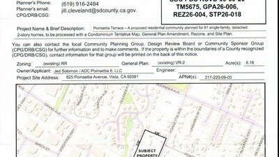

FORMAL OBJECTION AND OPPOSITION TO REZONING - Poinsettia Terrace (825 Poinsettia Avenue)
The Issue
September 20, 2026
County of San Diego
Department of Planning & Development Services (PDS)
Attention: Jill Cleveland, Project Planner
5510 Overland Ave, Suite 110
San Diego, CA 92123
Email: jill.cleveland@sdcounty.ca.gov
RE: FORMAL OBJECTION AND OPPOSITION
Record ID: TM5675, GPA26-006, REZ26-004, STP26-018
Project Name: Poinsettia Terrace (825 Poinsettia Avenue, Vista, CA 92081 /
APN: 217-220-09-00)
Dear Ms. Cleveland and Members of the Planning & Development Services Department,
We are writing as a nearby property owners/residents to express our strong opposition to the requested General Plan Amendment, Rezone, Condominium Tentative Map, and Site Plan for the proposed Poinsettia Terrace development located at 825 Poinsettia Avenue (Record ID: TM5675, GPA26-006, REZ26-004, STP26-018).
The application to build 61 detached homes on 6.16 acres represents an intense over-densification that is incompatible with the surrounding neighborhood. Increasing the density beyond the current Rural Residential (RR) zoning and VR-2 General Plan designations would negatively impact our immediate neighborhood and surrounding community. We respectfully request that the County deny the General Plan Amendment and Rezone based on the following formal grounds:
1. Incompatible Density and Community Character
The proposed density of nearly 10 homes per acre is completely incompatible with the existing Rural Residential (RR) neighborhood character, VR-2 General Plan designations, and surrounding low-density single-family lots. This extreme increase in intensity is drastically inconsistent with low-density residential standards maintained across the region:
- San Diego County: The site's current VR-2 General Plan designation strictly caps density at 2 units per gross acre. Jumping to nearly 10 units per acre undermines the County's semi-rural land-use framework.
- City of Vista: In the surrounding City of Vista jurisdiction, low-density single-family residential zones (such as E-1 and R-1-B) cap density at 1 to 4.3 units per acre to protect established neighborhood character.
- City of San Marcos: Neighboring jurisdictions like the City of San Marcos similarly restrict single-family residential zones (R-1) to low densities (typically 2 to 6 units per acre).
Approving nearly 10 units per acre on this 6.16-acre lot destroys the established semi-rural buffer and creates an arbitrary high-density island ("spot zoning") that conflicts with County, Vista, and regional planning norms.
2. Inconsistency with General Plan Policies
San Diego County General Plan Policy LU-1.3 requires new developments to maintain physical, visual, and spatial compatibility with existing surrounding parcels. Jump-scaling from a low-density Rural Residential footprint to a tightly packed 61-unit subdivision violates this fundamental planning policy and sets a harmful precedent for speculative upzoning in North County.
3. Traffic Hazards, Active Transportation Findings, and School Zone Safety
Poinsettia Avenue and Oleander Avenue already experience significant traffic congestion, and adding high-density residential traffic will create severe safety and ingress/egress hazards. Adding an estimated 500–600 daily vehicle trips onto Poinsettia Avenue and Oleander Avenue creates severe traffic queuing, blind-corner hazards, and sight-distance issues on narrow local roads. This traffic burden directly contradicts safety findings established by regional planners:
- Active Transportation Plan Findings: In 2022, the County of San Diego and the City of San Marcos updated their Active Transportation Plan in direct collaboration with the San Marcos Unified School District for areas surrounding Joli Ann Leichtag Elementary School located at 653 Poinsettia Ave, Vista, CA 92081. Through walk audits, classroom surveys, and extensive feedback from students, parents, teachers, and community members, planners formally evaluated local traffic safety and school zones.
- Downhill Gradient & Primary Crosswalk Hazard: That study concluded that adding a stoplight at the congested intersection would pose a significant liability and safety hazard. Because the main school entrance, which also serves directly as the school's primary student pedestrian crosswalk, enters at a direct downhill slope and cannot be reconfigured, a green light signal would allow vehicles traveling downhill to enter the school grounds and crosswalk at full speed without coming to a full stop, placing students and pedestrians at extreme risk.
- Compound Risk: Forcing an influx of over 100 resident vehicles into an already delicate traffic framework—where standard traffic control mitigations (like stoplights) create severe physical hazards and legal liabilities that cannot be engineered away—is unacceptable and dangerous.
4. Inadequate Infrastructure and Public Service Capacity
The existing water mains, sewer lines, and stormwater infrastructure in this area were designed to support low-density Rural Residential development. Increasing site density by this magnitude threatens to overtax local utility lines and stormwater drainage systems, significantly increasing off-site runoff risks onto neighboring lots. Additionally, no evidence has been provided that local schools and public services can absorb the sudden influx of families.
5. Severe Neighborhood and Privacy Impacts
Replacing low-density open land with 61 tightly packed, two-story structures creates significant visual massing and directly invades the privacy of neighboring single-story homes. The continuous operational noise from 61 exterior HVAC units, nighttime light trespass, and street-parking overflow will permanently degrade the quiet residential quality of our neighborhood.
6. Requirement for a Full Environmental Impact Report (EIR) Pursuant to CEQA Appendix G
Under the California Environmental Quality Act (CEQA), a Lead Agency must order a full Environmental Impact Report (EIR) whenever substantial evidence supports a "fair argument" that a project may produce significant direct, indirect, or cumulative environmental effects (14 CCR § 15064). Given the scale of the requested General Plan Amendment and Rezone on this 6.16-acre site, a Mitigated Negative Declaration (MND) is legally deficient. The EIR must comprehensively analyze the following CEQA Appendix G issue areas:
- Aesthetics: The massive jump in density alters the visual character of the semi-rural corridor. Furthermore, the EIR must analyze the potential buildout capacity assuming every single-family unit is entitled to an Accessory Dwelling Unit (ADU) and Junior ADU under state law, which would effectively double or triple site density, building massing, and structural heights.
- Air Quality: Increased traffic congestion and idling vehicles will elevate local pollutant concentrations. The EIR must analyze whether project emissions align with current regional transportation models and local air quality attainment plans.
- Biological Resources: A full biological survey must be mandated to evaluate nesting bird populations and raptor foraging habitats protected under the Migratory Bird Treaty Act and California Fish and Game Code prior to any site disturbance.
- Cultural Resources: The site must be evaluated against the County General Plan for potential historical significance, requiring formal historical and archaeological literature reviews and field surveys.
- Energy: The EIR must analyze the project’s total energy demand during both construction and operation, detailing how the 61 units will achieve energy self-sufficiency, offset grid demand, and incorporate renewable energy infrastructure.
- Geology and Soils: The County General Plan must be consulted to identify potential fault traces, seismic hazards, expansive soils, and slope instability on-site, requiring a full geotechnical evaluation and site-grading impact analysis.
- Greenhouse Gas (GHG) Emissions: The cumulative greenhouse gas emissions generated by project construction, equipment operation, and long-term mobile sources must be quantitatively modeled in conjunction with other nearby past, present, and reasonably foreseeable future developments.
- Hazards and Hazardous Materials:
- On-Site Agricultural Residuals: Given the historic/existing nursery operations on the parcel, a comprehensive Phase I and Phase II Environmental Site Assessment—including soil testing for residual pesticides, herbicides, and heavy metals—must be conducted.
- Underground Tanks & EnviroMapper: An evaluation of historical underground fuel storage tanks (USTs) via state databases (EnviroMapper / GeoTracker) is required.
- Wildfire Hazard: The EIR must evaluate whether the parcel falls within a Very High Fire Hazard Severity Zone per the County General Plan and evaluate emergency egress capacity.
- Roadway Hazards: The severe traffic liabilities identified at the downhill school entrance crosswalk must be analyzed as a significant design hazard.
- Hydrology and Water Quality: Replacing open land with extensive impervious surfaces increases runoff volume. The EIR must demonstrate how all stormwater will be retained and treated on-site in strict compliance with Regional Water Quality Control Board NPDES and Water Quality Management Plan (WQMP) regulations.
Land Use and Planning:
- Spot Zoning & Policy Conflict: The proposed density constitutes improper spot zoning. The developer's proposal to establish a custom Specific Plan to supersede the County General Plan is unacceptable; the EIR must include a rigorous General Plan Consistency Analysis evaluating whether overriding local goals sets a harmful regional precedent.
- Pedestrian Hostility: The analysis must evaluate the site's poor pedestrian connectivity, lack of sidewalks along rural corridors, and architectural incompatibility with surrounding single-family lots.
Noise: The EIR must include a formal acoustic study to evaluate heavy equipment construction noise, structural vibration, rock blasting/grading, and long-term operational noise (such as 61+ exterior HVAC units running along property lines).
Transportation (Vehicle Miles Traveled - VMT): Although CEQA no longer evaluates vehicular delay as an environmental impact, the EIR must conduct a detailed Vehicle Miles Traveled (VMT) analysis in strict conformance with SANDAG’s Regional Transportation Plan and state VMT reduction mandates.
Tribal Cultural Resources: As the region is the ancestral homeland of indigenous Native American tribes, the County must conduct a Native American Heritage Commission (NAHC) Sacred Lands File search and initiate formal SB 18 / AB 52 tribal consultations.
Utilities and Service Systems: The EIR must evaluate whether local water purveyors, sewer districts, and waste management services have adequate unallocated capacity to absorb a 61-unit subdivision without requiring secondary environmental impacts from utility extensions or upgrades.
The County needs to carefully consider what benefits, if any, the public receives from this application. The proposal lacks any meaningful public offerings to warrant overriding our existing General Plan protections.
Formal Request for Written Notice (Gov. Code § 65092 / § 65096)
Pursuant to California Government Code Sections 65092 and 65096, as well as CEQA guidelines, we hereby formally request written notice of any and all public hearings, staff reports, public comment periods, CEQA determinations (including EIR/ND filings), and official actions related to this project and its associated entitlements.
Respectfully Submitted,

262
The Issue
September 20, 2026
County of San Diego
Department of Planning & Development Services (PDS)
Attention: Jill Cleveland, Project Planner
5510 Overland Ave, Suite 110
San Diego, CA 92123
Email: jill.cleveland@sdcounty.ca.gov
RE: FORMAL OBJECTION AND OPPOSITION
Record ID: TM5675, GPA26-006, REZ26-004, STP26-018
Project Name: Poinsettia Terrace (825 Poinsettia Avenue, Vista, CA 92081 /
APN: 217-220-09-00)
Dear Ms. Cleveland and Members of the Planning & Development Services Department,
We are writing as a nearby property owners/residents to express our strong opposition to the requested General Plan Amendment, Rezone, Condominium Tentative Map, and Site Plan for the proposed Poinsettia Terrace development located at 825 Poinsettia Avenue (Record ID: TM5675, GPA26-006, REZ26-004, STP26-018).
The application to build 61 detached homes on 6.16 acres represents an intense over-densification that is incompatible with the surrounding neighborhood. Increasing the density beyond the current Rural Residential (RR) zoning and VR-2 General Plan designations would negatively impact our immediate neighborhood and surrounding community. We respectfully request that the County deny the General Plan Amendment and Rezone based on the following formal grounds:
1. Incompatible Density and Community Character
The proposed density of nearly 10 homes per acre is completely incompatible with the existing Rural Residential (RR) neighborhood character, VR-2 General Plan designations, and surrounding low-density single-family lots. This extreme increase in intensity is drastically inconsistent with low-density residential standards maintained across the region:
- San Diego County: The site's current VR-2 General Plan designation strictly caps density at 2 units per gross acre. Jumping to nearly 10 units per acre undermines the County's semi-rural land-use framework.
- City of Vista: In the surrounding City of Vista jurisdiction, low-density single-family residential zones (such as E-1 and R-1-B) cap density at 1 to 4.3 units per acre to protect established neighborhood character.
- City of San Marcos: Neighboring jurisdictions like the City of San Marcos similarly restrict single-family residential zones (R-1) to low densities (typically 2 to 6 units per acre).
Approving nearly 10 units per acre on this 6.16-acre lot destroys the established semi-rural buffer and creates an arbitrary high-density island ("spot zoning") that conflicts with County, Vista, and regional planning norms.
2. Inconsistency with General Plan Policies
San Diego County General Plan Policy LU-1.3 requires new developments to maintain physical, visual, and spatial compatibility with existing surrounding parcels. Jump-scaling from a low-density Rural Residential footprint to a tightly packed 61-unit subdivision violates this fundamental planning policy and sets a harmful precedent for speculative upzoning in North County.
3. Traffic Hazards, Active Transportation Findings, and School Zone Safety
Poinsettia Avenue and Oleander Avenue already experience significant traffic congestion, and adding high-density residential traffic will create severe safety and ingress/egress hazards. Adding an estimated 500–600 daily vehicle trips onto Poinsettia Avenue and Oleander Avenue creates severe traffic queuing, blind-corner hazards, and sight-distance issues on narrow local roads. This traffic burden directly contradicts safety findings established by regional planners:
- Active Transportation Plan Findings: In 2022, the County of San Diego and the City of San Marcos updated their Active Transportation Plan in direct collaboration with the San Marcos Unified School District for areas surrounding Joli Ann Leichtag Elementary School located at 653 Poinsettia Ave, Vista, CA 92081. Through walk audits, classroom surveys, and extensive feedback from students, parents, teachers, and community members, planners formally evaluated local traffic safety and school zones.
- Downhill Gradient & Primary Crosswalk Hazard: That study concluded that adding a stoplight at the congested intersection would pose a significant liability and safety hazard. Because the main school entrance, which also serves directly as the school's primary student pedestrian crosswalk, enters at a direct downhill slope and cannot be reconfigured, a green light signal would allow vehicles traveling downhill to enter the school grounds and crosswalk at full speed without coming to a full stop, placing students and pedestrians at extreme risk.
- Compound Risk: Forcing an influx of over 100 resident vehicles into an already delicate traffic framework—where standard traffic control mitigations (like stoplights) create severe physical hazards and legal liabilities that cannot be engineered away—is unacceptable and dangerous.
4. Inadequate Infrastructure and Public Service Capacity
The existing water mains, sewer lines, and stormwater infrastructure in this area were designed to support low-density Rural Residential development. Increasing site density by this magnitude threatens to overtax local utility lines and stormwater drainage systems, significantly increasing off-site runoff risks onto neighboring lots. Additionally, no evidence has been provided that local schools and public services can absorb the sudden influx of families.
5. Severe Neighborhood and Privacy Impacts
Replacing low-density open land with 61 tightly packed, two-story structures creates significant visual massing and directly invades the privacy of neighboring single-story homes. The continuous operational noise from 61 exterior HVAC units, nighttime light trespass, and street-parking overflow will permanently degrade the quiet residential quality of our neighborhood.
6. Requirement for a Full Environmental Impact Report (EIR) Pursuant to CEQA Appendix G
Under the California Environmental Quality Act (CEQA), a Lead Agency must order a full Environmental Impact Report (EIR) whenever substantial evidence supports a "fair argument" that a project may produce significant direct, indirect, or cumulative environmental effects (14 CCR § 15064). Given the scale of the requested General Plan Amendment and Rezone on this 6.16-acre site, a Mitigated Negative Declaration (MND) is legally deficient. The EIR must comprehensively analyze the following CEQA Appendix G issue areas:
- Aesthetics: The massive jump in density alters the visual character of the semi-rural corridor. Furthermore, the EIR must analyze the potential buildout capacity assuming every single-family unit is entitled to an Accessory Dwelling Unit (ADU) and Junior ADU under state law, which would effectively double or triple site density, building massing, and structural heights.
- Air Quality: Increased traffic congestion and idling vehicles will elevate local pollutant concentrations. The EIR must analyze whether project emissions align with current regional transportation models and local air quality attainment plans.
- Biological Resources: A full biological survey must be mandated to evaluate nesting bird populations and raptor foraging habitats protected under the Migratory Bird Treaty Act and California Fish and Game Code prior to any site disturbance.
- Cultural Resources: The site must be evaluated against the County General Plan for potential historical significance, requiring formal historical and archaeological literature reviews and field surveys.
- Energy: The EIR must analyze the project’s total energy demand during both construction and operation, detailing how the 61 units will achieve energy self-sufficiency, offset grid demand, and incorporate renewable energy infrastructure.
- Geology and Soils: The County General Plan must be consulted to identify potential fault traces, seismic hazards, expansive soils, and slope instability on-site, requiring a full geotechnical evaluation and site-grading impact analysis.
- Greenhouse Gas (GHG) Emissions: The cumulative greenhouse gas emissions generated by project construction, equipment operation, and long-term mobile sources must be quantitatively modeled in conjunction with other nearby past, present, and reasonably foreseeable future developments.
- Hazards and Hazardous Materials:
- On-Site Agricultural Residuals: Given the historic/existing nursery operations on the parcel, a comprehensive Phase I and Phase II Environmental Site Assessment—including soil testing for residual pesticides, herbicides, and heavy metals—must be conducted.
- Underground Tanks & EnviroMapper: An evaluation of historical underground fuel storage tanks (USTs) via state databases (EnviroMapper / GeoTracker) is required.
- Wildfire Hazard: The EIR must evaluate whether the parcel falls within a Very High Fire Hazard Severity Zone per the County General Plan and evaluate emergency egress capacity.
- Roadway Hazards: The severe traffic liabilities identified at the downhill school entrance crosswalk must be analyzed as a significant design hazard.
- Hydrology and Water Quality: Replacing open land with extensive impervious surfaces increases runoff volume. The EIR must demonstrate how all stormwater will be retained and treated on-site in strict compliance with Regional Water Quality Control Board NPDES and Water Quality Management Plan (WQMP) regulations.
Land Use and Planning:
- Spot Zoning & Policy Conflict: The proposed density constitutes improper spot zoning. The developer's proposal to establish a custom Specific Plan to supersede the County General Plan is unacceptable; the EIR must include a rigorous General Plan Consistency Analysis evaluating whether overriding local goals sets a harmful regional precedent.
- Pedestrian Hostility: The analysis must evaluate the site's poor pedestrian connectivity, lack of sidewalks along rural corridors, and architectural incompatibility with surrounding single-family lots.
Noise: The EIR must include a formal acoustic study to evaluate heavy equipment construction noise, structural vibration, rock blasting/grading, and long-term operational noise (such as 61+ exterior HVAC units running along property lines).
Transportation (Vehicle Miles Traveled - VMT): Although CEQA no longer evaluates vehicular delay as an environmental impact, the EIR must conduct a detailed Vehicle Miles Traveled (VMT) analysis in strict conformance with SANDAG’s Regional Transportation Plan and state VMT reduction mandates.
Tribal Cultural Resources: As the region is the ancestral homeland of indigenous Native American tribes, the County must conduct a Native American Heritage Commission (NAHC) Sacred Lands File search and initiate formal SB 18 / AB 52 tribal consultations.
Utilities and Service Systems: The EIR must evaluate whether local water purveyors, sewer districts, and waste management services have adequate unallocated capacity to absorb a 61-unit subdivision without requiring secondary environmental impacts from utility extensions or upgrades.
The County needs to carefully consider what benefits, if any, the public receives from this application. The proposal lacks any meaningful public offerings to warrant overriding our existing General Plan protections.
Formal Request for Written Notice (Gov. Code § 65092 / § 65096)
Pursuant to California Government Code Sections 65092 and 65096, as well as CEQA guidelines, we hereby formally request written notice of any and all public hearings, staff reports, public comment periods, CEQA determinations (including EIR/ND filings), and official actions related to this project and its associated entitlements.
Respectfully Submitted,
The Decision Makers


Supporter Voices
Petition Updates
Share this petition
Petition created on September 21, 2026