
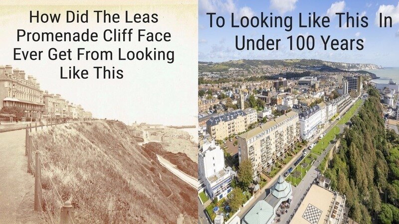
How Did The Leas Promenade Cliff Face Ever Get From Looking Like A Grassy Rolling Slope To Looking Like A Steep Forest Ravine In Under 100 Years?
Well, if you look at the earlier photo, you can see there is no lampposts along the Leas. These were installed sometime between the late 19th and early 20th centuries. They were initially gas lamps and were converted to electric ones by 1928. So I'm guessing that this first photo was taken at the turn of the century, about 1900.
So, how has the whole of the Leas top and lower Leas changed so dramatically in less than 100 years to the point where we only know the cliff face/hillside topography by looking at earlier photos and paintings?
Initial land acquisition
In 1697, Jacob de Bouverie (a predecessor to the Earls of Radnor) bought the "Honour and Lordship of Folkestone and Terlingham" from Sir Basil Dixwell. The estate, which was part of the original
Manor of Folkestone
, covered over 4,500 acres and included:
• Several farms
• A significant amount of woodland
• The area known as The Warren�
• The beach down to the low-water mark
• The site of the current harbour
• Stone quarries
So the Leas as we know it now was formed back in 1784 when a massive landslide occurred stretching over a mile from the Harbour to Sandate. This created a new strip of land between the front of the new cliff face and the beach, measuring maybe 30 meters wide.
The land was owned by the Earl of Radnor, who seized on the opportunity in 1828 to open up a toll-paying road connecting Sandgate with the harbour. He built a toll house which charged horse-drawn vehicles to make the easier route between both ends of the Leas without having to climb up Sandgate Road. Paths were put in from the upper to lower Leas; one such was called the Cow Path, which enabled farmers to bring their cattle down to the lower Leas to graze on the pasture land.
Before that In 1804, the Earl of Radnor petitioned Parliament for the construction of a stone harbour in Folkestone. The acceptance and completion of this project in 1810 significantly boosted the town's trade and commerce, making the Earl an influential figure in the town's development.
In 1913, the area then known as Leas Cliff was leased by the Radnor Estate to the local corporation, to be used mainly for a park, but the estate still kept the tolls from the toll road. In the park, tea rooms, shelters, and woodland walks were provided among the newly planted in the 1880s of Holm Oaks and Pine trees so that people could “take the air”.
The planting was intended to provide a picturesque and formal landscape for promenading, a contrast to the wilder, grassy slopes that existed before.
This historic planting was followed by other trees, including self-seeded sycamores, which have contributed to the current coastal woodland environment.
The choice of pine trees and holm oaks was also practical, as they were selected for their ability to withstand the specific coastal environment, which includes salty air and dry conditions.
Estate-driven development: The trees were planted by the Radnor Estate, which owned the land and leased it to the local corporation in 1913 for park use.
Victorian purpose: The planting was part of a broader Victorian effort to create scenic woodland walks where people could "take the air". This provided a pleasant recreational area for visitors and residents.
Part of a larger plan: The pines were planted alongside holm oaks and other plants chosen for their ability to thrive in dry conditions and salty air.
Current-day concerns: While historically significant, some of the pine trees are now a topic of discussion due to their potential impact on the hillside's stability.
Holm oaks are not indigenous to the UK and were introduced from the Mediterranean in the 16th century. They are considered fast-growing in sunny locations, can tolerate salt-spray and shade, and are sometimes classified as an invasive species in the UK due to their ability to spread and thrive. As a tree, they can reach 20-25 meters (65-82 feet) in height. In some parts of the UK, they are considered a non-native invasive species because of their ability to spread easily and produce large quantities of seeds that germinate readily. Unlike native oaks, it is an evergreen tree, which provides year-round colour and screening.
Now here's the threat: holm oak wood is dense, slow-burning, and excellent for firewood and charcoal, while its evergreen leaves are highly flammable. This flammability, combined with the dense, smoldering properties of the wood, makes it a significant fire hazard in its native Mediterranean climate. We only need a really hot, dry summer and a discarded cigarette butt, and we have a recipe for disaster. As we have said before, trees growing on cliff tops and hillsides where the topsoil might be just a few meters deep, sitting on what we have in Folkestone a mixture of sand, sandstone, and clay that the roots do not penetrate below the soil depth, as there are no nutrients for them. So the roots tend to grow up and down and across the slopes, making them not very deep-rooted. As we have seen, growing in these conditions with each rainfall washing the soil off the roots that the roots eventually become exposed and as as happened on the Road of Remembrance, with large amounts of continuous rainfall and blown about in every strong wind and gust, where the force of the wind retonates through these sail like branches down the tree trunk rocking and destablising the roots until they simply slid down the hill bolt upright rootball and all.
FHDC arboriculturalist never saw it coming so how can we have any faith in the council or their tree boffin if they failed us so miserably over this?
As for Sycamores, they are also non indigenous, a fast-growing invasive species, almost a weed. Left unchecked as they are along the Leas mid-slopes and cliff top, like the Holm Oaks, they might well have looked like a prettier backdrop to the coastal park than tall grasses that once graced its banks, but to the cliff face/hillside, they have become a serious threat now to its stability and loss of sea views from the promenade.
Yes, the Scots Pines look magnificent, but in many places along the Leas, they have been allowed to grow far too tall and heavy, undermining the stability of the very top of the cliff and Zig Zag path as well as obliterating sea views. Remember, the Leas Promenade was created by the Victorians and Edwardians as a cliff-top coastal walk, taking in at the time unhampered views of the sea from east to west, a balcony overlooking the English Channel, and not as it is rapidly becoming, due to decades of neglect and continual growth, a walk in the woods.
Threats and dangers of Scots Pines
Destabilization of rock and soil: Scots pine roots can exploit and widen existing cracks in rock faces, potentially leading to rockfalls.
Uprooting during storms: Strong winds on exposed clifftops can uproot large Scots pines, which can pull out large sections of soil and rock. In one instance, a storm ripped over 20 Scots pines out of a hillside, drastically changing the landscape.
Invasive potential: As a pioneer species, Scots pines produce abundant seeds that can spread rapidly by wind. This can allow them to colonize and spread aggressively in new areas, outcompeting native coastal vegetation and dramatically changing the natural landscape.
Wildfire hazard: Like many conifers, pines are highly flammable due to their resinous wood and needles. A dense stand of pines on a cliff top increases the risk and intensity of wildfires.
So there we have it, how has our Leas cliff face/hillside has changed so rapidly over the course of a century is largely due to design when the coastal park was first laid out, and neglect on the part of councils over the past 40 years or more who have basically just let the trees run and spread like wildfire across the midslopes and the cliff top. Yet still, after all the landslides that have occurred, FHDC still ignores the threat and no doubt will continue to right up till they cease to exist as an authority sometime in 2028. If this lot won't do anything about the threat, then god help us, because when the much larger Unitary Authority comes into effect, they may well be even less likely to do anything more than what FHDC has done, which is to mop up after an event rather than take action to prevent it occurring.
Stephen West
-----------------------------------------------------------------------------------
Please keep on sharing our petition to your friends and family and our Facebook Group.