
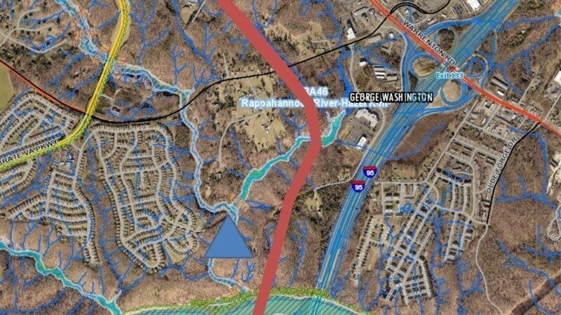
River Crossing Option A has a high Impact to the streams that lead to the Waterfall identified by the blue triangle. There will also be a high amount of traffic noise on the trail and the waterfall.
FAMPO is doing a River Crossing Location Survey. They ask for a location ranking.
Special interests are pushing for Option A.
My recommended rankings are B-2 followed by B-1, C, A and D last.
https://survey123.arcgis.com/.../25ed12ae0cc94b7bbb9543ea
Option B-2 is the best River Crossing Option for the following reasons:
1. Least direct impact to private property, only two landowners directly impacted (City of Fredericksburg and the Silver Company).
2. Least environmental impacts to Resource Protection Areas.
3. Shorter connection with the least clearing and Enviromental footprint.
4. Option B-2 has the highest traffic demand and timesaving factor of 55.3%, which cuts travel time in half to get thousands of cars off the road quicker cutting back on air pollution.
5. Both B Options cost millions less than Option A.
6. Option B has no impact on the Waterfall.
7. Option B is far enough from I-95 where the traffic noise will not impact the serenity on the bridge trail overlook. There would also be more scenic views without having to look at and hear I-95.
8. The long bridge span B-2 has a much smaller footprint and has much less Enviromental damage to the RPA than the many culverts and Stream disturbances of option A.
9. Option B-2 is about 1/8 of a mile shorter than option B-1.
The projected traffic counts for 2050 are 40,000 trips per day.
A 1/8-mile reduction of 40,000 trips is a reduction in miles driven of 5,000 miles per day, which will significantly reduce air pollution.
10. A longer bridge will allow the runoff to be controlled for greater distances to be channeled to more environmentally friendly locations for containment and treatment before it reaches the river.
11. Option B maximizes the use of over $100 M in existing infrastructure and will have better traffic flow than the other options. The many connections to Route 17 and the Celebrate Virginia transportation grid will diffuse traffic congestion.
12. Option B-2 will improve Fire and Rescue Response and Transport times in some areas of Stafford, especially in the Del Webb Senior Community.
The study shows driving from the Del Webb Senior Community to Mary Washington Hospital currently takes 30 minutes, but with option B-2 it would take 10.2 minutes to transport to Mary Washington Hospital. That's a reduction of about 20 minutes of transport time. Reducing 20 minutes off the time our ambulances are out of service. Putting our ambulances back in service 20 minutes quicker can't be overstated.
It will take 10 years until the bridge is built. The seniors will be older and might want to live 20 minutes closer to the hospital. I'm sure family members will appreciate saving an extra 20 minutes each way to the hospital. Stafford has a high transient rate of about 11% to 14%. In 10 years, most will not be here.
13. Establishing a Regional Park will mitigate the impacts to the conservation easements, providing more recreational opportunities, protecting open space and showcasing dozens of historic sites.
14. The river crossing at option A would put the parking too close to the waterfall. I believe the parking should be over a mile away, so that people will not bring as much trash. Having the parking too close would trash the area around the waterfall. The runoff from option A construction will silt up the waterfall.
Read more here on my Facebook Page and feel free to friend or follow me
(2) Joe Brito - Please help choose the location of the River Crossing... | Facebook
Thanks for reading and taking the survey,
Joe Brito