Adopt South-Up Maps in Schools and Media: Decolonize Global Geography
Adopt South-Up Maps in Schools and Media: Decolonize Global Geography
The Issue
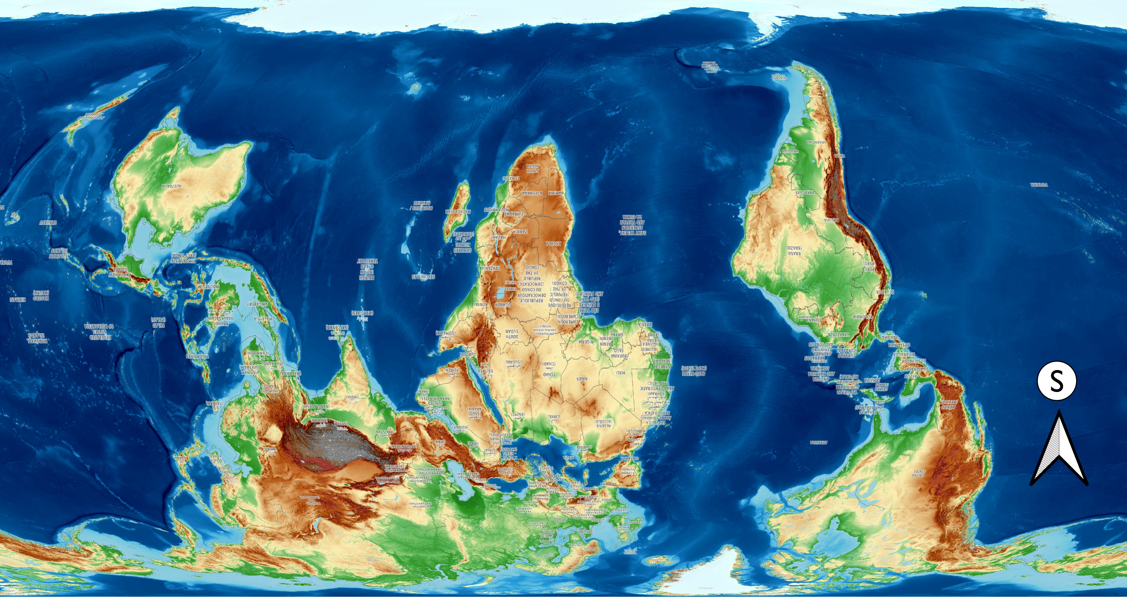
We are calling on educational authorities, publishers, and international organizations to formally integrate and normalize South-up world maps in school curricula, textbooks, and public media. For centuries, North-up maps have subtly reinforced a spatial bias that positions the Global North as "above" and Africa as "below." It is time to flip the perspective—literally and symbolically.
Re-Orienting the Globe: The Case for South-Up Cartography and Decolonizing Spatial Psychology
Abstract
For centuries, standard cartography has placed the Northern Hemisphere at the top of world maps. While often dismissed as an arbitrary convention, this orientation carries profound psychological, cultural, and political consequences. In cognitive linguistics, "up" is subconsciously paired with power, superiority, and progress, whereas "down" signifies subordination, passivity, and inferiority.
By deconstructing the myth that North is "up," analysing topographical realities, examining cultural tropes (such as Toto’s popular reference to "down in Africa"), and drawing on historical precedents like Al-Idrisi’s medieval maps, this paper argues that adopting South-up cartography is a vital step toward decolonizing global spatial perception and elevating the collective self-worth of the African continent and the Global South.
1. Dismantling the Myth: North Is Not "Up"
In fundamental physics and astronomy, space has no intrinsic "up" or "down." Planet Earth is a sphere suspended in space, orbiting the sun along an ecliptic plane. Directional vectors such as North, South, East, and West are spatial coordinates—not indicators of altitude or cosmic priority.
The placement of North at the top of modern maps is an artifact of European maritime history. During the Age of Exploration, European cartographers (most notably Gerardus Mercator in 1569) designed maps primarily for nautical navigation using magnetic compasses aligned with the North Star (Polaris). Over time, what began as a functional tool for navigation was codified into a normative global standard, conflating North with "up."
2. The Physical Reality: Elevation, Topography, and High Ground
If "up" were to represent actual physical elevation relative to sea level, conventional maps would be geographically inverted:
- Africa’s High Plateau: Africa is dominated by massive elevated tablelands and plateaus. Middle, Eastern, and Southern Africa boast an average elevation of 1,000 to 2,000 meters above sea level. Regions such as the Ethiopian Highlands ("the Roof of Africa"), the East African Plateau, and the South African Highveld sit significantly higher than most continental landmasses.
- Northern Lowlands: In contrast, vast regions of Northern Europe and Eurasia consist of low-lying plains. Countries like the Netherlands, Northern Germany, Poland, and vast swathes of Western Russia sit near or even below sea level.
- Physically and topographically, Africa holds the literal "high ground" of the planet compared to the lowlands of Western Europe. Orienting South as "up" reflects topographical elevation far more accurately than North-up projections.
3. Psychological Impact: Spatial Metaphors and Cultural Conditioning
Cognitive psychologists George Lakoff and Mark Johnson demonstrated in Metaphors We Live By that human thought is deeply structured by spatial metaphors:
- UP = Good, High Status, Power, Dominance, Endowed (full of natural resources), Growth ("moving up," "top tier," "upper class").
- DOWN = Bad, Low Status, Subordination, Decline ("feeling down," "bottom of the pile," "underdeveloped").
When children globally grow up looking at maps where Europe and North America sit comfortably at the top while Africa is continuously positioned at the bottom, an implicit cognitive bias takes root. Africa is spatialized as "below," "under," and "down."
The Cultural Trope of "Down in Africa"
This cognitive bias permeates pop culture and global discourse. A prime example is the iconic line from Toto’s 1982 hit song Africa:
"I bless the rains down in Africa..."
While written without explicit malice, the casual reference to Africa as "down" reflects a ubiquitous geopolitical language: people speak of going "down to Africa" or referring to the Global South as an "under-region." This language reinforces a subconscious worldview where Africa is perpetually beneath the Global North.
4. Historical Precedents: Al-Idrisi and Pre-Colonial Mapping
South-up mapping is neither a novel gimmick nor an artificial modern creation. In medieval cartography, map orientations varied widely based on cultural priorities:
- Christian Medieval Europe: Often placed East at the top ("orienting" the map toward Jerusalem and the Garden of Eden).
- Islamic Golden Age: Geographers frequently placed South at the top.
The most famous example is the Tabula Rogeriana drawn in 1154 CE by Moroccan-born Arab geographer Muhammad al-Idrisi for King Roger II of Sicily. Al-Idrisi placed South at the top of his world map, centering Africa and the Arabian Peninsula prominently across the upper expanse of the known world.
5. Conclusion: Re-Orienting Maps as an Act of Liberation
Decolonization requires dismantling not only physical borders and economic dependency, but also the mental models that shape human perception. Adopting South-up maps in educational curricula, media, and public institutions disrupts centuries of Eurocentric spatial hierarchy.
When African children see their continent standing proudly at the top of the globe—vast, elevated, and central—it directly challenges internalized narratives of inferiority. Changing our maps changes our mental models, reminding the world that direction is relative, but dignity is absolute.

21
The Issue
We are calling on educational authorities, publishers, and international organizations to formally integrate and normalize South-up world maps in school curricula, textbooks, and public media. For centuries, North-up maps have subtly reinforced a spatial bias that positions the Global North as "above" and Africa as "below." It is time to flip the perspective—literally and symbolically.
Re-Orienting the Globe: The Case for South-Up Cartography and Decolonizing Spatial Psychology
Abstract
For centuries, standard cartography has placed the Northern Hemisphere at the top of world maps. While often dismissed as an arbitrary convention, this orientation carries profound psychological, cultural, and political consequences. In cognitive linguistics, "up" is subconsciously paired with power, superiority, and progress, whereas "down" signifies subordination, passivity, and inferiority.
By deconstructing the myth that North is "up," analysing topographical realities, examining cultural tropes (such as Toto’s popular reference to "down in Africa"), and drawing on historical precedents like Al-Idrisi’s medieval maps, this paper argues that adopting South-up cartography is a vital step toward decolonizing global spatial perception and elevating the collective self-worth of the African continent and the Global South.
1. Dismantling the Myth: North Is Not "Up"
In fundamental physics and astronomy, space has no intrinsic "up" or "down." Planet Earth is a sphere suspended in space, orbiting the sun along an ecliptic plane. Directional vectors such as North, South, East, and West are spatial coordinates—not indicators of altitude or cosmic priority.
The placement of North at the top of modern maps is an artifact of European maritime history. During the Age of Exploration, European cartographers (most notably Gerardus Mercator in 1569) designed maps primarily for nautical navigation using magnetic compasses aligned with the North Star (Polaris). Over time, what began as a functional tool for navigation was codified into a normative global standard, conflating North with "up."
2. The Physical Reality: Elevation, Topography, and High Ground
If "up" were to represent actual physical elevation relative to sea level, conventional maps would be geographically inverted:
- Africa’s High Plateau: Africa is dominated by massive elevated tablelands and plateaus. Middle, Eastern, and Southern Africa boast an average elevation of 1,000 to 2,000 meters above sea level. Regions such as the Ethiopian Highlands ("the Roof of Africa"), the East African Plateau, and the South African Highveld sit significantly higher than most continental landmasses.
- Northern Lowlands: In contrast, vast regions of Northern Europe and Eurasia consist of low-lying plains. Countries like the Netherlands, Northern Germany, Poland, and vast swathes of Western Russia sit near or even below sea level.
- Physically and topographically, Africa holds the literal "high ground" of the planet compared to the lowlands of Western Europe. Orienting South as "up" reflects topographical elevation far more accurately than North-up projections.
3. Psychological Impact: Spatial Metaphors and Cultural Conditioning
Cognitive psychologists George Lakoff and Mark Johnson demonstrated in Metaphors We Live By that human thought is deeply structured by spatial metaphors:
- UP = Good, High Status, Power, Dominance, Endowed (full of natural resources), Growth ("moving up," "top tier," "upper class").
- DOWN = Bad, Low Status, Subordination, Decline ("feeling down," "bottom of the pile," "underdeveloped").
When children globally grow up looking at maps where Europe and North America sit comfortably at the top while Africa is continuously positioned at the bottom, an implicit cognitive bias takes root. Africa is spatialized as "below," "under," and "down."
The Cultural Trope of "Down in Africa"
This cognitive bias permeates pop culture and global discourse. A prime example is the iconic line from Toto’s 1982 hit song Africa:
"I bless the rains down in Africa..."
While written without explicit malice, the casual reference to Africa as "down" reflects a ubiquitous geopolitical language: people speak of going "down to Africa" or referring to the Global South as an "under-region." This language reinforces a subconscious worldview where Africa is perpetually beneath the Global North.
4. Historical Precedents: Al-Idrisi and Pre-Colonial Mapping
South-up mapping is neither a novel gimmick nor an artificial modern creation. In medieval cartography, map orientations varied widely based on cultural priorities:
- Christian Medieval Europe: Often placed East at the top ("orienting" the map toward Jerusalem and the Garden of Eden).
- Islamic Golden Age: Geographers frequently placed South at the top.
The most famous example is the Tabula Rogeriana drawn in 1154 CE by Moroccan-born Arab geographer Muhammad al-Idrisi for King Roger II of Sicily. Al-Idrisi placed South at the top of his world map, centering Africa and the Arabian Peninsula prominently across the upper expanse of the known world.
5. Conclusion: Re-Orienting Maps as an Act of Liberation
Decolonization requires dismantling not only physical borders and economic dependency, but also the mental models that shape human perception. Adopting South-up maps in educational curricula, media, and public institutions disrupts centuries of Eurocentric spatial hierarchy.
When African children see their continent standing proudly at the top of the globe—vast, elevated, and central—it directly challenges internalized narratives of inferiority. Changing our maps changes our mental models, reminding the world that direction is relative, but dignity is absolute.
Petition Updates
Share this petition
Petition created on 5 September 2026